Rosà elevation
Rosà (Veneto, Provincia di Vicenza), Italy elevation is 76 meters and Rosà elevation in feet is 249 ft above sea level [src 1]. Rosà is a seat of a third-order administrative division (feature code) with elevation that is 246 meters (807 ft) smaller than average city elevation in Italy.
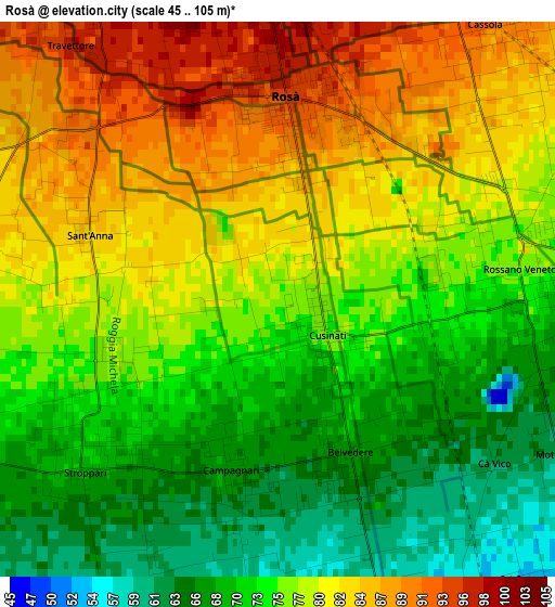
Below is the Elevation map of Rosà, which displays elevation range with different colors. Scale of the first map is from 45 to 105 m (148 to 344 ft) with average elevation of 76.4 meters (=251 ft) [note 1]
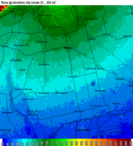
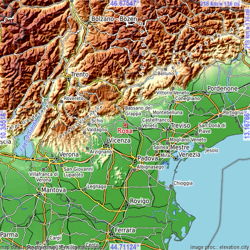
These maps also provides idea of topography and contour of this city, they are displayed at different zoom levels. More info about maps, scale and edge coordinates you can find below images.
| \ | Map #1 | Map #2 | Topo.Map |
| Scale [m] | 45..105 m | 33..252 m | × |
| Scale [ft] | 148..344 ft | 108..827 ft | × |
| Average | 76.4 m = 251 ft | 73.7 m = 242 ft | × |
| Width | 6.82 km = 4.2 mi | 13.65 km = 8.5 mi | 218.4 km = 135.7 mi |
| Height | 6.83 km = 4.2 mi | 13.65 km = 8.5 mi | 218.4 km = 135.7 mi |
| ↑Max Latitude | 45.732663° | 45.763328° | 46.67547° |
| Latitude at center | 45.70198° | 45.70198° | 45.70198° |
| ↓Min Latitude | 45.671281° | 45.640564° | 44.71124° |
| ← Min Longitude | 11.717465° | 11.673519° | 10.35516° |
| Longitude center | 11.76141° | 11.76141° | 11.76141° |
| →Max Longitude | 11.805355° | 11.849301° | 13.16766° |
Nearby cities:
Cities around Rosà sort by population:
• Bassano del Grappa elevation 112 m
7.7 km,  339°
339°
• Cittadella 47 m
6.6 km,  164°
164°
• San Zeno-San Giuseppe 117 m
6.1 km,  0°
0°
• Rossano Veneto 74 m
3.3 km,  87°
87°
• Belvedere 69 m
1.6 km,  148°
148°
• Galliera Veneta 53 m
6.1 km,  129°
129°
• Fontaniva 43 m
7.5 km,  184°
184°
• Nove 81 m
6.8 km,  288°
288°
• Tezze 72 m
4.4 km,  252°
252°
• Cassola 91 m
4.6 km,  39°
39°
• Cartigliano 86 m
5.3 km,  283°
283°
• Casoni 100 m
7.4 km,  30°
30°
Multilingual:
 En español:
Rosà elevación 76 m.
 En France:
Rosà élévation 76 m.


Sources and notes:
- [note 1] Map square and city borders are not equal. Map elevation data is calculated only from area inside that square.
- [src 1] Elevation data from geonames database provided with same terms of usage.
- [src 2] The elevation map of Rosà is generated using elevation data from NASA's 3 arcsec (90m) resolution SRTM data.
- [src 3] Base (background) map © OpenStreetMap contributors tiles are generated by Geofabrik and OpenTopoMap.
Copyright & License:
This Rosà Elevation Map is licensed under CC BY-SA. You may reuse any part from this page, if you give a proper credit by linking to this URL:
 More info on terms of use page.