Cartigliano elevation
Cartigliano (Veneto, Provincia di Vicenza), Italy elevation is 86 meters and Cartigliano elevation in feet is 282 ft above sea level [src 1]. Cartigliano is a seat of a third-order administrative division (feature code) with elevation that is 236 meters (774 ft) smaller than average city elevation in Italy.
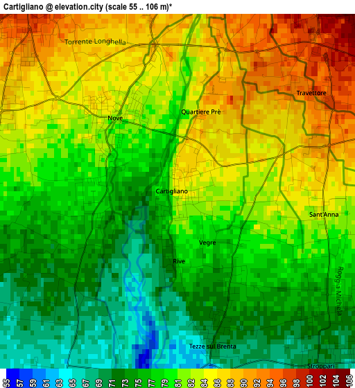
Below is the Elevation map of Cartigliano, which displays elevation range with different colors. Scale of the first map is from 55 to 106 m (180 to 348 ft) with average elevation of 80.1 meters (=263 ft) [note 1]
These maps also provides idea of topography and contour of this city, they are displayed at different zoom levels. More info about maps, scale and edge coordinates you can find below images.
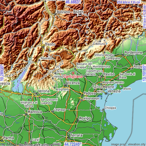
| \ | Map #1 | Topo.Map |
| Scale [m] | 55..106 m | × |
| Scale [ft] | 180..348 ft | × |
| Average | 80.1 m = 263 ft | × |
| Width | 6.82 km = 4.2 mi | 218.4 km = 135.7 mi |
| Height | 6.82 km = 4.2 mi | 218.3 km = 135.6 mi |
| ↑Max Latitude | 45.743677° | 46.6863° |
| Latitude at center | 45.713° | 45.713° |
| ↓Min Latitude | 45.682307° | 44.72245° |
| ← Min Longitude | 11.651655° | 10.28935° |
| Longitude center | 11.6956° | 11.6956° |
| →Max Longitude | 11.739545° | 13.10185° |
Nearby cities:
Cities around Cartigliano sort by population:
• Bassano del Grappa elevation 112 m
6.4 km,  22°
22°
• Rosà 76 m
5.3 km,  103°
103°
• San Zeno-San Giuseppe 117 m
7.1 km,  46°
46°
• Marostica 100 m
4.4 km,  324°
324°
• Belvedere 69 m
6.4 km,  113°
113°
• Nove 81 m
1.6 km,  305°
305°
• Tezze 72 m
2.7 km,  161°
161°
• Mason Vicentino 105 m
6.9 km,  275°
275°
• Pozzoleone 52 m
7.3 km,  195°
195°
• Schiavon 71 m
4.3 km,  244°
244°
• Mure 116 m
7 km,  289°
289°
• Pianezze 162 m
6.2 km,  300°
300°
Multilingual:
 En español:
Cartigliano elevación 86 m.
 En France:
Cartigliano élévation 86 m.
 Auf Deutsch:
Cartigliano höhe über dem Meeresspiegel ist 86 m.

Sources and notes:
- [note 1] Map square and city borders are not equal. Map elevation data is calculated only from area inside that square.
- [src 1] Elevation data from geonames database provided with same terms of usage.
- [src 2] The elevation map of Cartigliano is generated using elevation data from NASA's 3 arcsec (90m) resolution SRTM data.
- [src 3] Base (background) map © OpenStreetMap contributors tiles are generated by Geofabrik and OpenTopoMap.
Copyright & License:
This Cartigliano Elevation Map is licensed under CC BY-SA. You may reuse any part from this page, if you give a proper credit by linking to this URL:
 More info on terms of use page.