Sirmione elevation
Sirmione (Lombardy, Provincia di Brescia), Italy elevation is 91 meters and Sirmione elevation in feet is 299 ft above sea level [src 1]. Sirmione is a seat of a third-order administrative division (feature code) with elevation that is 231 meters (758 ft) smaller than average city elevation in Italy.
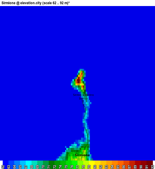
Below is the Elevation map of Sirmione, which displays elevation range with different colors. Scale of the first map is from 62 to 92 m (203 to 302 ft) with average elevation of 62.4 meters (=205 ft) [note 1]
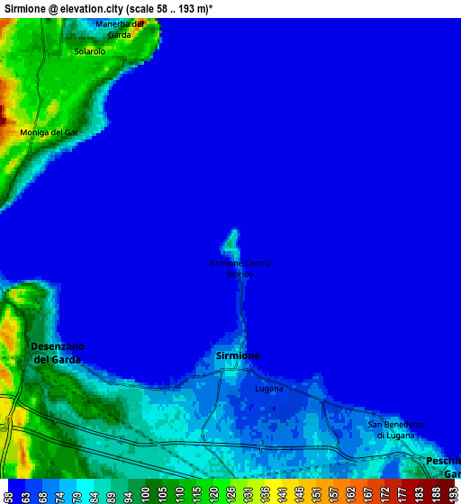
These maps also provides idea of topography and contour of this city, they are displayed at different zoom levels. More info about maps, scale and edge coordinates you can find below images.
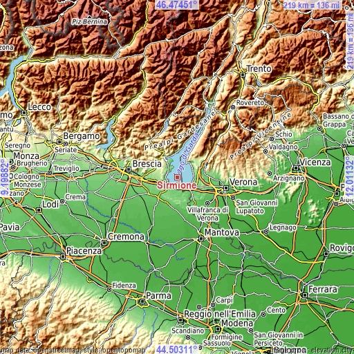
| \ | Map #1 | Map #2 | Topo.Map |
| Scale [m] | 62..92 m | 58..193 m | × |
| Scale [ft] | 203..302 ft | 190..633 ft | × |
| Average | 62.4 m = 205 ft | 72.5 m = 238 ft | × |
| Width | 6.85 km = 4.3 mi | 13.7 km = 8.5 mi | 219.2 km = 136.2 mi |
| Height | 6.85 km = 4.3 mi | 13.7 km = 8.5 mi | 219.2 km = 136.2 mi |
| ↑Max Latitude | 45.528235° | 45.559012° | 46.47451° |
| Latitude at center | 45.49744° | 45.49744° | 45.49744° |
| ↓Min Latitude | 45.466628° | 45.4358° | 44.50311° |
| ← Min Longitude | 10.561125° | 10.517179° | 9.19882° |
| Longitude center | 10.60507° | 10.60507° | 10.60507° |
| →Max Longitude | 10.649015° | 10.692961° | 12.01132° |
Nearby cities:
Cities around Sirmione sort by population:
• Desenzano del Garda elevation 88 m
6.1 km,  241°
241°
• Peschiera del Garda 82 m
9.1 km,  135°
135°
• Padenghe sul Garda 74 m
6.8 km,  279°
279°
• Manerba del Garda 135 m
7.1 km,  324°
324°
• Solarolo 115 m
7.1 km,  326°
326°
• San Felice del Benaco 98 m
10.3 km,  337°
337°
• Lazise 86 m
10.5 km,  85°
85°
• Moniga del Garda 118 m
6.2 km,  301°
301°
• San Martino della Battaglia 83 m
6.6 km,  183°
183°
• Soiano 197 m
8 km, 295°
• Raffa 137 m
10 km, 324°
• Polpenazze del Garda 210 m
9.8 km,  307°
307°
Multilingual:
 En español:
Sirmione elevación 91 m.
 En France:
Sirmione élévation 91 m.


Sources and notes:
- [note 1] Map square and city borders are not equal. Map elevation data is calculated only from area inside that square.
- [src 1] Elevation data from geonames database provided with same terms of usage.
- [src 2] The elevation map of Sirmione is generated using elevation data from NASA's 3 arcsec (90m) resolution SRTM data.
- [src 3] Base (background) map © OpenStreetMap contributors tiles are generated by Geofabrik and OpenTopoMap.
Copyright & License:
This Sirmione Elevation Map is licensed under CC BY-SA. You may reuse any part from this page, if you give a proper credit by linking to this URL:
 More info on terms of use page.