Padenghe sul Garda elevation
Padenghe sul Garda (Lombardy, Provincia di Brescia), Italy elevation is 74 meters and Padenghe sul Garda elevation in feet is 243 ft above sea level [src 1]. Padenghe sul Garda is a seat of a third-order administrative division (feature code) with elevation that is 248 meters (814 ft) smaller than average city elevation in Italy.
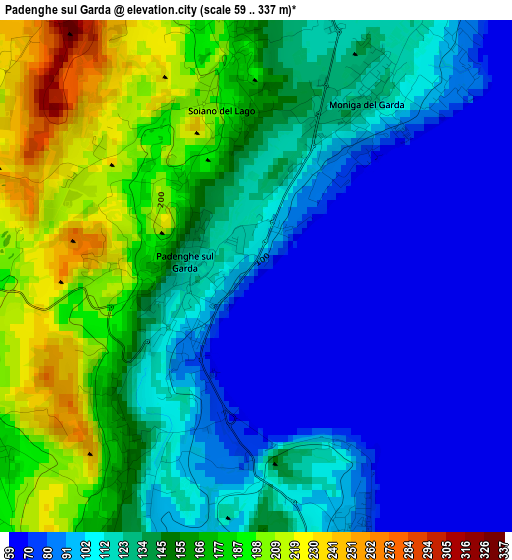
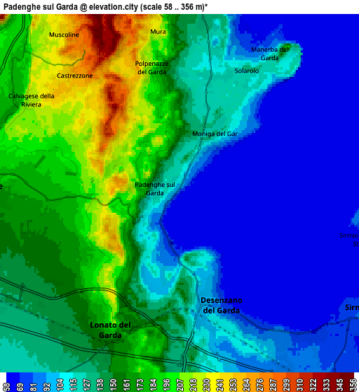
Below is the Elevation map of Padenghe sul Garda, which displays elevation range with different colors. Scale of the first map is from 59 to 337 m (194 to 1106 ft) with average elevation of 131.4 meters (=431 ft) [note 1]
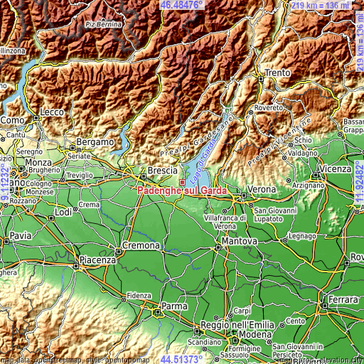
These maps also provides idea of topography and contour of this city, they are displayed at different zoom levels. More info about maps, scale and edge coordinates you can find below images.
| \ | Map #1 | Map #2 | Topo.Map |
| Scale [m] | 59..337 m | 58..356 m | × |
| Scale [ft] | 194..1106 ft | 190..1168 ft | × |
| Average | 131.4 m = 431 ft | 134 m = 440 ft | × |
| Width | 6.85 km = 4.3 mi | 13.7 km = 8.5 mi | 219.2 km = 136.2 mi |
| Height | 6.85 km = 4.3 mi | 13.7 km = 8.5 mi | 219.1 km = 136.1 mi |
| ↑Max Latitude | 45.538659° | 45.569431° | 46.48476° |
| Latitude at center | 45.50787° | 45.50787° | 45.50787° |
| ↓Min Latitude | 45.477064° | 45.446242° | 44.51373° |
| ← Min Longitude | 10.474625° | 10.430679° | 9.11232° |
| Longitude center | 10.51857° | 10.51857° | 10.51857° |
| →Max Longitude | 10.562515° | 10.606461° | 11.92482° |
Nearby cities:
Cities around Padenghe sul Garda sort by population:
• Desenzano del Garda elevation 88 m
4.3 km,  161°
161°
• Lonato 161 m
6.1 km,  211°
211°
• Sirmione 91 m
6.8 km,  99°
99°
• Manerba del Garda 135 m
5.4 km,  29°
29°
• Solarolo 115 m
5.5 km, 30°
• Puegnago sul Garda 217 m
6.6 km,  354°
354°
• Moniga del Garda 118 m
2.5 km, 34°
• Soiano 197 m
2.3 km, 348°
• Polpenazze del Garda 210 m
4.9 km, 347°
• Castello 229 m
6.9 km, 353°
• Carzago Riviera 203 m
4.9 km,  292°
292°
• Calvagese della Riviera 221 m
6.6 km,  301°
301°
Multilingual:
 En español:
Padenghe sul Garda elevación 74 m.
 En France:
Padenghe sul Garda élévation 74 m.
 Auf Deutsch:
Padenghe sul Garda höhe über dem Meeresspiegel ist 74 m.

Sources and notes:
- [note 1] Map square and city borders are not equal. Map elevation data is calculated only from area inside that square.
- [src 1] Elevation data from geonames database provided with same terms of usage.
- [src 2] The elevation map of Padenghe sul Garda is generated using elevation data from NASA's 3 arcsec (90m) resolution SRTM data.
- [src 3] Base (background) map © OpenStreetMap contributors tiles are generated by Geofabrik and OpenTopoMap.
Copyright & License:
This Padenghe sul Garda Elevation Map is licensed under CC BY-SA. You may reuse any part from this page, if you give a proper credit by linking to this URL:
 More info on terms of use page.