Soiano elevation
Soiano (Lombardy, Provincia di Brescia), Italy elevation is 197 meters and Soiano elevation in feet is 646 ft above sea level [src 1]. Soiano is a seat of a third-order administrative division (feature code) with elevation that is 125 meters (410 ft) smaller than average city elevation in Italy.
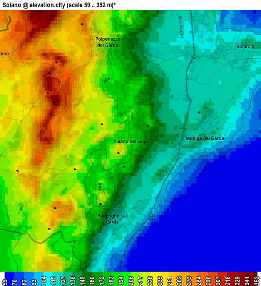
Below is the Elevation map of Soiano, which displays elevation range with different colors. Scale of the first map is from 59 to 352 m (194 to 1155 ft) with average elevation of 163.3 meters (=536 ft) [note 1]
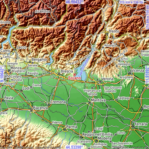
These maps also provides idea of topography and contour of this city, they are displayed at different zoom levels. More info about maps, scale and edge coordinates you can find below images.
| \ | Map #1 | Topo.Map |
| Scale [m] | 59..352 m | × |
| Scale [ft] | 194..1155 ft | × |
| Average | 163.3 m = 536 ft | × |
| Width | 6.85 km = 4.3 mi | 219.1 km = 136.1 mi |
| Height | 6.85 km = 4.3 mi | 219.1 km = 136.1 mi |
| ↑Max Latitude | 45.558558° | 46.50432° |
| Latitude at center | 45.52778° | 45.52778° |
| ↓Min Latitude | 45.496985° | 44.53398° |
| ← Min Longitude | 10.468725° | 9.10642° |
| Longitude center | 10.51267° | 10.51267° |
| →Max Longitude | 10.556615° | 11.91892° |
Nearby cities:
Cities around Soiano sort by population:
• Padenghe sul Garda elevation 74 m
2.3 km,  168°
168°
• Manerba del Garda 135 m
3.9 km,  51°
51°
• Solarolo 115 m
4.1 km, 52°
• Puegnago sul Garda 217 m
4.3 km,  357°
357°
• Moniga del Garda 118 m
1.9 km,  93°
93°
• Muscoline 246 m
5.5 km,  314°
314°
• Raffa 137 m
4.9 km,  15°
15°
• Polpenazze del Garda 210 m
2.7 km,  346°
346°
• Castello 229 m
4.7 km, 356°
• Carzago Riviera 203 m
4.1 km,  264°
264°
• Chiesa 247 m
5.6 km,  315°
315°
• Calvagese della Riviera 221 m
5.3 km,  283°
283°
Multilingual:
 En español:
Soiano elevación 197 m.
 En France:
Soiano élévation 197 m.


Sources and notes:
- [note 1] Map square and city borders are not equal. Map elevation data is calculated only from area inside that square.
- [src 1] Elevation data from geonames database provided with same terms of usage.
- [src 2] The elevation map of Soiano is generated using elevation data from NASA's 3 arcsec (90m) resolution SRTM data.
- [src 3] Base (background) map © OpenStreetMap contributors tiles are generated by Geofabrik and OpenTopoMap.
Copyright & License:
This Soiano Elevation Map is licensed under CC BY-SA. You may reuse any part from this page, if you give a proper credit by linking to this URL:
 More info on terms of use page.