Raffa elevation
Raffa (Lombardy, Provincia di Brescia), Italy elevation is 137 meters and Raffa elevation in feet is 449 ft above sea level [src 1]. Raffa is a populated place (feature code) with elevation that is 185 meters (607 ft) smaller than average city elevation in Italy.
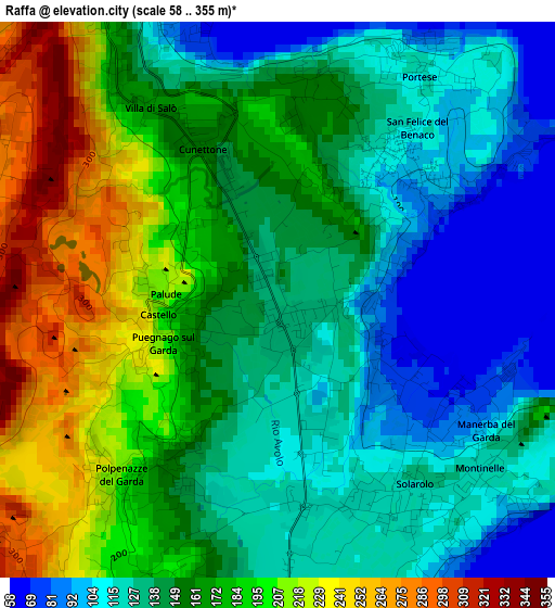
Below is the Elevation map of Raffa, which displays elevation range with different colors. Scale of the first map is from 58 to 355 m (190 to 1165 ft) with average elevation of 157.3 meters (=516 ft) [note 1]
These maps also provides idea of topography and contour of this city, they are displayed at different zoom levels. More info about maps, scale and edge coordinates you can find below images.
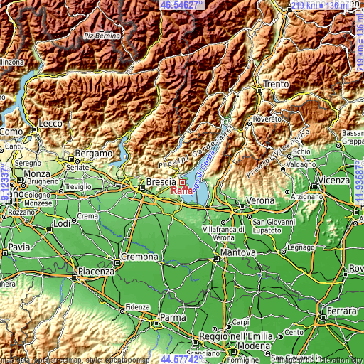
| \ | Map #1 | Topo.Map |
| Scale [m] | 58..355 m | × |
| Scale [ft] | 190..1165 ft | × |
| Average | 157.3 m = 516 ft | × |
| Width | 6.84 km = 4.3 mi | 218.9 km = 136 mi |
| Height | 6.84 km = 4.3 mi | 218.9 km = 136 mi |
| ↑Max Latitude | 45.601225° | 46.54627° |
| Latitude at center | 45.57047° | 45.57047° |
| ↓Min Latitude | 45.539698° | 44.57742° |
| ← Min Longitude | 10.485675° | 9.12337° |
| Longitude center | 10.52962° | 10.52962° |
| →Max Longitude | 10.573565° | 11.93587° |
Nearby cities:
Cities around Raffa sort by population:
• Salò elevation 79 m
4.1 km,  350°
350°
• Manerba del Garda 135 m
2.9 km,  142°
142°
• Solarolo 115 m
3 km, 138°
• San Felice del Benaco 98 m
2.3 km,  54°
54°
• Puegnago sul Garda 217 m
1.6 km,  255°
255°
• Moniga del Garda 118 m
4.9 km,  173°
173°
• Muscoline 246 m
5.3 km, 260°
• Soiano 197 m
4.9 km,  195°
195°
• Polpenazze del Garda 210 m
2.9 km,  221°
221°
• Cunettone-Villa 155 m
2.2 km,  334°
334°
• Castello 229 m
1.6 km,  266°
266°
• San Giacomo 339 m
4.9 km,  302°
302°
Multilingual:
 En español:
Raffa elevación 137 m.
 En France:
Raffa élévation 137 m.


Sources and notes:
- [note 1] Map square and city borders are not equal. Map elevation data is calculated only from area inside that square.
- [src 1] Elevation data from geonames database provided with same terms of usage.
- [src 2] The elevation map of Raffa is generated using elevation data from NASA's 3 arcsec (90m) resolution SRTM data.
- [src 3] Base (background) map © OpenStreetMap contributors tiles are generated by Geofabrik and OpenTopoMap.
Copyright & License:
This Raffa Elevation Map is licensed under CC BY-SA. You may reuse any part from this page, if you give a proper credit by linking to this URL:
 More info on terms of use page.