Abirāmam elevation
Abirāmam (Tamil Nadu, Rāmanāthapuram), India elevation is 45 meters and Abirāmam elevation in feet is 148 ft above sea level [src 1]. Abirāmam is a populated place (feature code) with elevation that is 248 meters (814 ft) smaller than average city elevation in India.
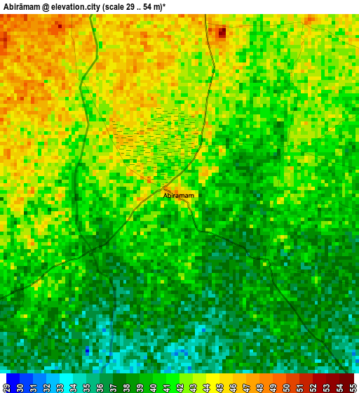
Below is the Elevation map of Abirāmam, which displays elevation range with different colors. Scale of the first map is from 29 to 54 m (95 to 177 ft) with average elevation of 40.6 meters (=133 ft) [note 1]
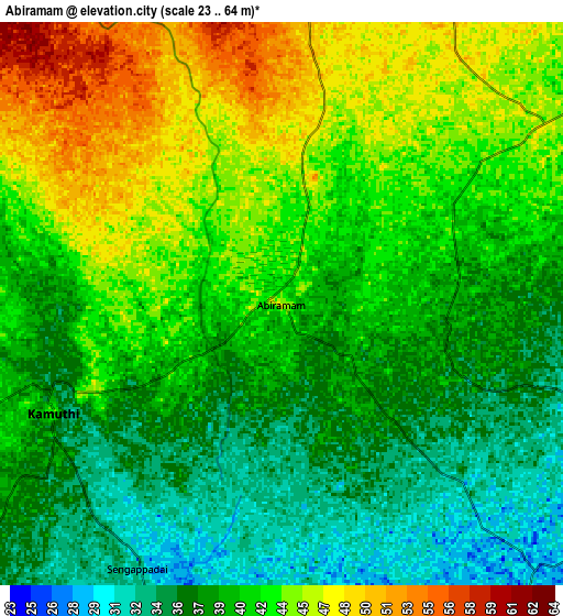
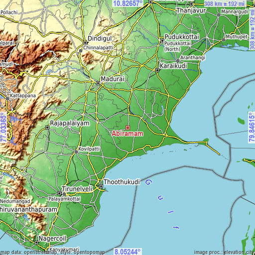
These maps also provides idea of topography and contour of this city, they are displayed at different zoom levels. More info about maps, scale and edge coordinates you can find below images.
| \ | Map #1 | Map #2 | Topo.Map |
| Scale [m] | 29..54 m | 23..64 m | × |
| Scale [ft] | 95..177 ft | 75..210 ft | × |
| Average | 40.6 m = 133 ft | 40.7 m = 134 ft | × |
| Width | 9.64 km = 6 mi | 19.28 km = 12 mi | 308.5 km = 191.7 mi |
| Height | 9.64 km = 6 mi | 19.28 km = 12 mi | 308.5 km = 191.7 mi |
| ↑Max Latitude | 9.485647° | 9.528989° | 10.82657° |
| Latitude at center | 9.4423° | 9.4423° | 9.4423° |
| ↓Min Latitude | 9.398947° | 9.355589° | 8.05244° |
| ← Min Longitude | 78.395955° | 78.352009° | 77.03365° |
| Longitude center | 78.4399° | 78.4399° | 78.4399° |
| →Max Longitude | 78.483845° | 78.527791° | 79.84615° |
Nearby cities:
Cities around Abirāmam sort by population:
• Paramagudi elevation 46 m
20.2 km,  55°
55°
• Aruppukkottai 100 m
38.5 km,  281°
281°
• Ramanathapuram 10 m
43.6 km,  100°
100°
• Sivaganga 103 m
45.3 km,  6°
6°
• Keelakarai 14 m
44.6 km,  121°
121°
• Manamadurai 72 m
25.9 km, 7°
• Kariapatti 91 m
45.4 km,  304°
304°
• Mudukulattūr 28 m
13.8 km,  144°
144°
• Kamuthi 33 m
8.3 km,  241°
241°
• Sāyalkudi 12 m
30.4 km,  178°
178°
• Mangalam 52 m
42.1 km,  31°
31°
• Pudūr 59 m
37.1 km, 243°
Multilingual:
 En español:
Abirāmam elevación 45 m.
 En France:
Abirāmam élévation 45 m.


Sources and notes:
- [note 1] Map square and city borders are not equal. Map elevation data is calculated only from area inside that square.
- [src 1] Elevation data from geonames database provided with same terms of usage.
- [src 2] The elevation map of Abirāmam is generated using elevation data from NASA's 3 arcsec (90m) resolution SRTM data.
- [src 3] Base (background) map © OpenStreetMap contributors tiles are generated by Geofabrik and OpenTopoMap.
Copyright & License:
This Abirāmam Elevation Map is licensed under CC BY-SA. You may reuse any part from this page, if you give a proper credit by linking to this URL:
 More info on terms of use page.