Pudūr elevation
Pudūr (Tamil Nadu, Thoothukkudi), India elevation is 59 meters and Pudūr elevation in feet is 194 ft above sea level [src 1]. Pudūr is a populated place (feature code) with elevation that is 234 meters (768 ft) smaller than average city elevation in India.
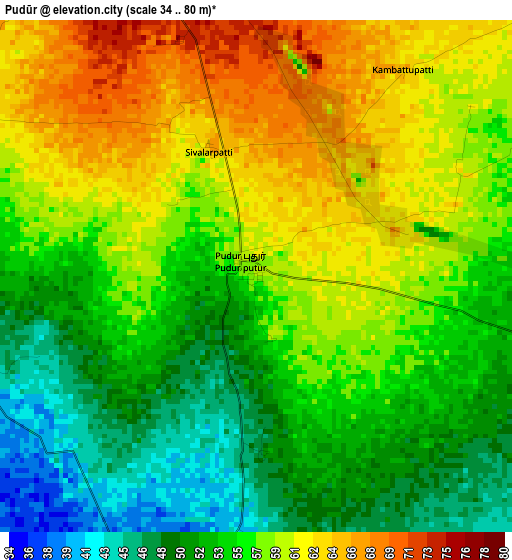
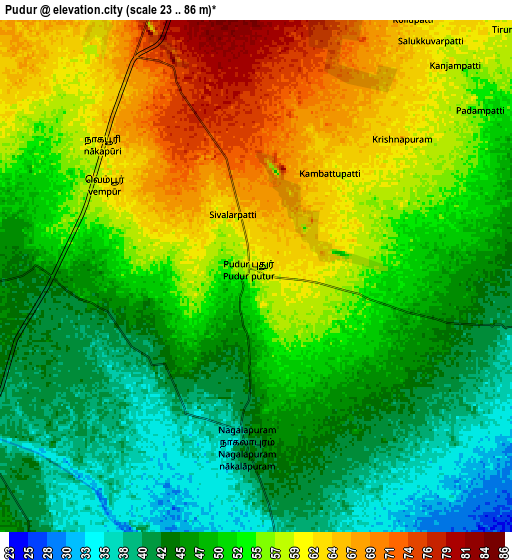
Below is the Elevation map of Pudūr, which displays elevation range with different colors. Scale of the first map is from 34 to 80 m (112 to 262 ft) with average elevation of 56.2 meters (=184 ft) [note 1]
These maps also provides idea of topography and contour of this city, they are displayed at different zoom levels. More info about maps, scale and edge coordinates you can find below images.
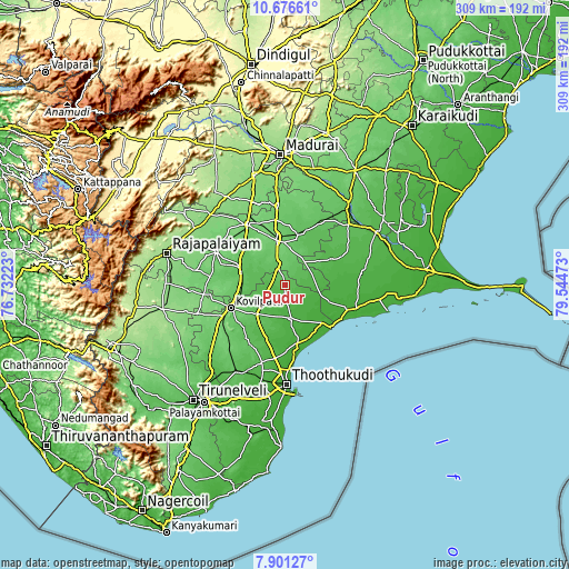
| \ | Map #1 | Map #2 | Topo.Map |
| Scale [m] | 34..80 m | 23..86 m | × |
| Scale [ft] | 112..262 ft | 75..282 ft | × |
| Average | 56.2 m = 184 ft | 52 m = 171 ft | × |
| Width | 9.64 km = 6 mi | 19.29 km = 12 mi | 308.6 km = 191.8 mi |
| Height | 9.64 km = 6 mi | 19.29 km = 12 mi | 308.6 km = 191.8 mi |
| ↑Max Latitude | 9.335056° | 9.378417° | 10.67661° |
| Latitude at center | 9.29169° | 9.29169° | 9.29169° |
| ↓Min Latitude | 9.248319° | 9.204942° | 7.90127° |
| ← Min Longitude | 78.094535° | 78.050589° | 76.73223° |
| Longitude center | 78.13848° | 78.13848° | 78.13848° |
| →Max Longitude | 78.182425° | 78.226371° | 79.54473° |
Nearby cities:
Cities around Pudūr sort by population:
• Kovilpatti elevation 106 m
32.4 km,  245°
245°
• Aruppukkottai 100 m
24.7 km,  349°
349°
• Virudunagar 105 m
38.2 km,  328°
328°
• Tiruttangal 88 m
39.7 km,  302°
302°
• Sattur 66 m
24.5 km,  286°
286°
• Vilattikulam 28 m
18 km,  170°
170°
• Kamuthi 33 m
28.8 km,  63°
63°
• Ettaiyapuram 63 m
23.1 km,  224°
224°
• Sāyalkudi 12 m
36.5 km,  111°
111°
• Kulattūr 17 m
32.6 km, 169°
• Abirāmam 45 m
37.1 km, 63°
• Elāyirampannai 103 m
34.5 km,  266°
266°
Multilingual:
 En español:
Pudūr elevación 59 m.
 En France:
Pudūr élévation 59 m.


Sources and notes:
- [note 1] Map square and city borders are not equal. Map elevation data is calculated only from area inside that square.
- [src 1] Elevation data from geonames database provided with same terms of usage.
- [src 2] The elevation map of Pudūr is generated using elevation data from NASA's 3 arcsec (90m) resolution SRTM data.
- [src 3] Base (background) map © OpenStreetMap contributors tiles are generated by Geofabrik and OpenTopoMap.
Copyright & License:
This Pudūr Elevation Map is licensed under CC BY-SA. You may reuse any part from this page, if you give a proper credit by linking to this URL:
 More info on terms of use page.