Manamadurai elevation
Manamadurai (Tamil Nadu, Sivaganga), India elevation is 72 meters and Manamadurai elevation in feet is 236 ft above sea level [src 1]. Manamadurai is a populated place (feature code) with elevation that is 221 meters (725 ft) smaller than average city elevation in India.
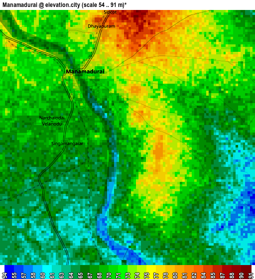
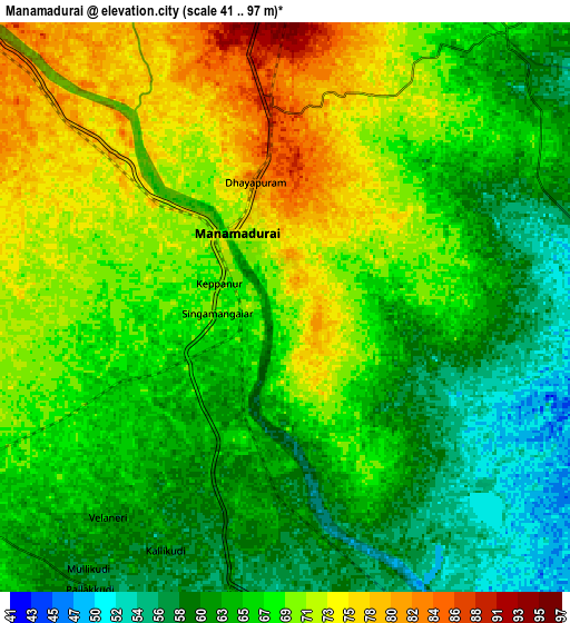
Below is the Elevation map of Manamadurai, which displays elevation range with different colors. Scale of the first map is from 54 to 91 m (177 to 299 ft) with average elevation of 69.2 meters (=227 ft) [note 1]
These maps also provides idea of topography and contour of this city, they are displayed at different zoom levels. More info about maps, scale and edge coordinates you can find below images.
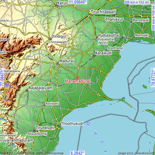
| \ | Map #1 | Map #2 | Topo.Map |
| Scale [m] | 54..91 m | 41..97 m | × |
| Scale [ft] | 177..299 ft | 135..318 ft | × |
| Average | 69.2 m = 227 ft | 66.6 m = 219 ft | × |
| Width | 9.63 km = 6 mi | 19.27 km = 12 mi | 308.2 km = 191.5 mi |
| Height | 9.63 km = 6 mi | 19.27 km = 12 mi | 308.3 km = 191.6 mi |
| ↑Max Latitude | 9.716498° | 9.75981° | 11.05645° |
| Latitude at center | 9.67318° | 9.67318° | 9.67318° |
| ↓Min Latitude | 9.629857° | 9.586528° | 8.2842° |
| ← Min Longitude | 78.427015° | 78.383069° | 77.06471° |
| Longitude center | 78.47096° | 78.47096° | 78.47096° |
| →Max Longitude | 78.514905° | 78.558851° | 79.87721° |
Nearby cities:
Cities around Manamadurai sort by population:
• Madurai elevation 138 m
47.2 km,  305°
305°
• Paramagudi 46 m
19.3 km,  137°
137°
• Aruppukkottai 100 m
45 km,  246°
246°
• Sivaganga 103 m
19.4 km,  4°
4°
• Melur 154 m
42.5 km,  340°
340°
• Tiruppuvanam 109 m
28.8 km, 305°
• Kariapatti 91 m
40.7 km,  270°
270°
• Mudukulattūr 28 m
37.2 km,  172°
172°
• Kamuthi 33 m
31.4 km,  199°
199°
• Mangalam 52 m
21.2 km,  61°
61°
• Abirāmam 45 m
25.9 km,  187°
187°
• Nāttarasankottai 88 m
23.6 km,  22°
22°
Multilingual:
 En español:
Manamadurai elevación 72 m.
 En France:
Manamadurai élévation 72 m.
 Auf Deutsch:
Manamadurai höhe über dem Meeresspiegel ist 72 m.

Sources and notes:
- [note 1] Map square and city borders are not equal. Map elevation data is calculated only from area inside that square.
- [src 1] Elevation data from geonames database provided with same terms of usage.
- [src 2] The elevation map of Manamadurai is generated using elevation data from NASA's 3 arcsec (90m) resolution SRTM data.
- [src 3] Base (background) map © OpenStreetMap contributors tiles are generated by Geofabrik and OpenTopoMap.
Copyright & License:
This Manamadurai Elevation Map is licensed under CC BY-SA. You may reuse any part from this page, if you give a proper credit by linking to this URL:
 More info on terms of use page.