Mangalam elevation
Mangalam (Tamil Nadu, Sivaganga), India elevation is 52 meters and Mangalam elevation in feet is 171 ft above sea level [src 1]. Mangalam is a populated place (feature code) with elevation that is 241 meters (791 ft) smaller than average city elevation in India.
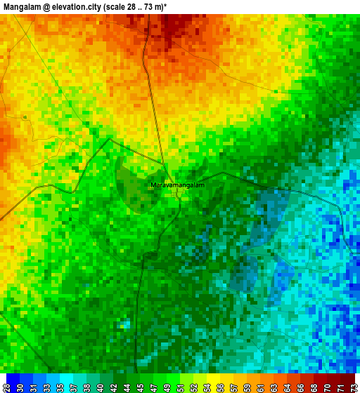
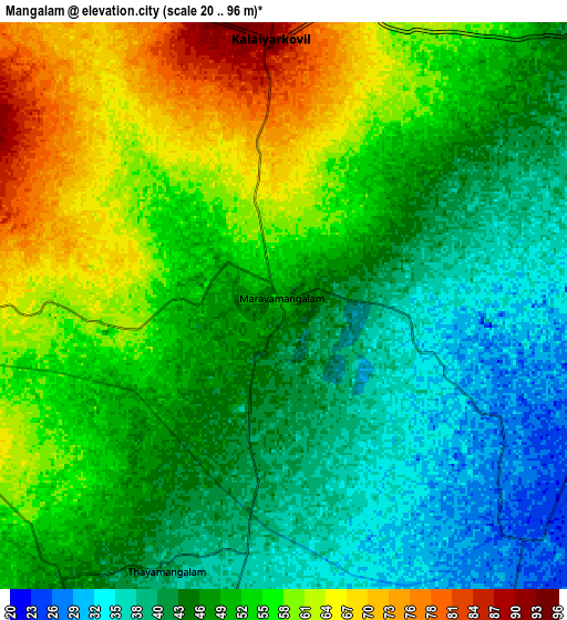
Below is the Elevation map of Mangalam, which displays elevation range with different colors. Scale of the first map is from 28 to 73 m (92 to 240 ft) with average elevation of 47.9 meters (=157 ft) [note 1]
These maps also provides idea of topography and contour of this city, they are displayed at different zoom levels. More info about maps, scale and edge coordinates you can find below images.
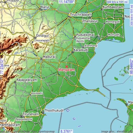
| \ | Map #1 | Map #2 | Topo.Map |
| Scale [m] | 28..73 m | 20..96 m | × |
| Scale [ft] | 92..240 ft | 66..315 ft | × |
| Average | 47.9 m = 157 ft | 50.3 m = 165 ft | × |
| Width | 9.63 km = 6 mi | 19.26 km = 12 mi | 308.2 km = 191.5 mi |
| Height | 9.63 km = 6 mi | 19.26 km = 12 mi | 308.2 km = 191.5 mi |
| ↑Max Latitude | 9.808036° | 9.851336° | 11.14759° |
| Latitude at center | 9.76473° | 9.76473° | 9.76473° |
| ↓Min Latitude | 9.721419° | 9.678101° | 8.3761° |
| ← Min Longitude | 78.596425° | 78.552479° | 77.23412° |
| Longitude center | 78.64037° | 78.64037° | 78.64037° |
| →Max Longitude | 78.684315° | 78.728261° | 80.04662° |
Nearby cities:
Cities around Mangalam sort by population:
• Kāraikkudi elevation 85 m
36.3 km,  22°
22°
• Paramagudi 46 m
24.9 km,  192°
192°
• Sivaganga 103 m
19.5 km,  298°
298°
• Devakottai 53 m
28.5 km,  44°
44°
• Manamadurai 72 m
21.2 km,  241°
241°
• Tiruppuvanam 109 m
42.4 km,  279°
279°
• Tondi 9 m
41.4 km,  93°
93°
• Kottaiyūr 103 m
41.9 km, 23°
• Tiruppālaikudi 9 m
38.9 km,  128°
128°
• Nambutalai 6 m
40.4 km,  95°
95°
• Abirāmam 45 m
42.1 km,  211°
211°
• Nāttarasankottai 88 m
15 km,  320°
320°
Multilingual:
 En español:
Mangalam elevación 52 m.
 En France:
Mangalam élévation 52 m.


Sources and notes:
- [note 1] Map square and city borders are not equal. Map elevation data is calculated only from area inside that square.
- [src 1] Elevation data from geonames database provided with same terms of usage.
- [src 2] The elevation map of Mangalam is generated using elevation data from NASA's 3 arcsec (90m) resolution SRTM data.
- [src 3] Base (background) map © OpenStreetMap contributors tiles are generated by Geofabrik and OpenTopoMap.
Copyright & License:
This Mangalam Elevation Map is licensed under CC BY-SA. You may reuse any part from this page, if you give a proper credit by linking to this URL:
 More info on terms of use page.