Aizawl elevation
Aizawl (Mizoram), India elevation is 1080 meters and Aizawl elevation in feet is 3543 ft above sea level [src 1]. Aizawl is a seat of a first-order administrative division (feature code) with elevation that is 787 meters (2582 ft) bigger than average city elevation in India.
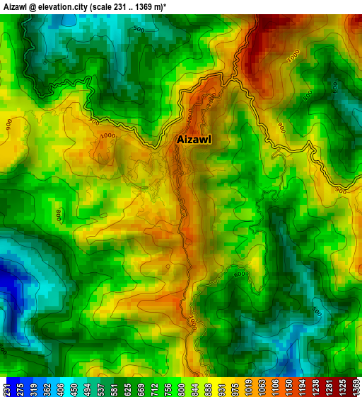
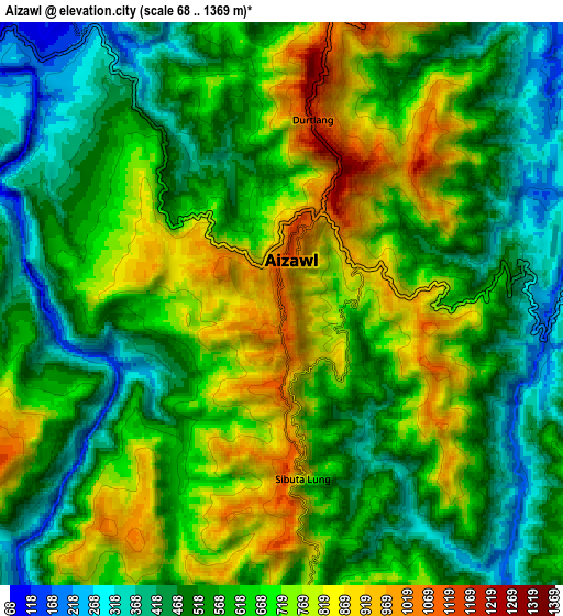
Below is the Elevation map of Aizawl, which displays elevation range with different colors. Scale of the first map is from 231 to 1369 m (758 to 4491 ft) with average elevation of 773.4 meters (=2537 ft) [note 1]
These maps also provides idea of topography and contour of this city, they are displayed at different zoom levels. More info about maps, scale and edge coordinates you can find below images.
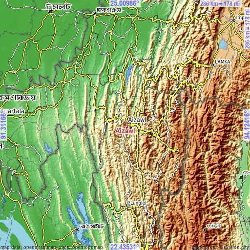
| \ | Map #1 | Map #2 | Topo.Map |
| Scale [m] | 231..1369 m | 68..1369 m | × |
| Scale [ft] | 758..4491 ft | 223..4491 ft | × |
| Average | 773.4 m = 2537 ft | 620.3 m = 2035 ft | × |
| Width | 8.95 km = 5.6 mi | 17.89 km = 11.1 mi | 286.3 km = 177.9 mi |
| Height | 8.95 km = 5.6 mi | 17.89 km = 11.1 mi | 286.3 km = 177.9 mi |
| ↑Max Latitude | 23.769164° | 23.809375° | 25.00986° |
| Latitude at center | 23.72894° | 23.72894° | 23.72894° |
| ↓Min Latitude | 23.688704° | 23.648455° | 22.43531° |
| ← Min Longitude | 92.673965° | 92.630019° | 91.31166° |
| Longitude center | 92.71791° | 92.71791° | 92.71791° |
| →Max Longitude | 92.761855° | 92.805801° | 94.12416° |
Nearby cities:
Cities around Aizawl sort by population:
• Dharmanagar elevation 32 m
90.3 km,  321°
321°
• Kolasib 661 m
55.2 km,  355°
355°
• Serchhīp 1231 m
50.2 km,  164°
164°
• Sāitlaw 799 m
30.7 km,  331°
331°
• Āmbāsa 81 m
90.8 km,  284°
284°
• Mamit 870 m
32 km,  313°
313°
• Thenzawl 831 m
46 km,  175°
175°
• Sairang 111 m
11.2 km, 323°
• Darlawn 1119 m
38 km,  33°
33°
• North Vanlaiphai 1385 m
75.2 km,  151°
151°
• Khawhai 1335 m
57.2 km,  133°
133°
• Pherzawl 1017 m
76.2 km,  38°
38°
Multilingual:
 En español:
Aizawl elevación 1080 m.
 En France:
Aizawl élévation 1080 m.


Sources and notes:
- [note 1] Map square and city borders are not equal. Map elevation data is calculated only from area inside that square.
- [src 1] Elevation data from geonames database provided with same terms of usage.
- [src 2] The elevation map of Aizawl is generated using elevation data from NASA's 3 arcsec (90m) resolution SRTM data.
- [src 3] Base (background) map © OpenStreetMap contributors tiles are generated by Geofabrik and OpenTopoMap.
Copyright & License:
This Aizawl Elevation Map is licensed under CC BY-SA. You may reuse any part from this page, if you give a proper credit by linking to this URL:
 More info on terms of use page.