Kolasib elevation
Kolasib (Mizoram, Kolasib district), India elevation is 661 meters and Kolasib elevation in feet is 2169 ft above sea level [src 1]. Kolasib is a populated place (feature code) with elevation that is 368 meters (1207 ft) bigger than average city elevation in India.
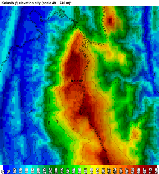
Below is the Elevation map of Kolasib, which displays elevation range with different colors. Scale of the first map is from 49 to 740 m (161 to 2428 ft) with average elevation of 291.3 meters (=956 ft) [note 1]
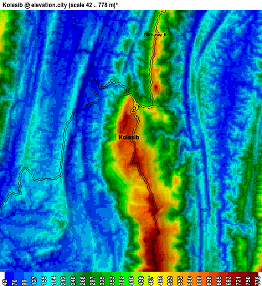
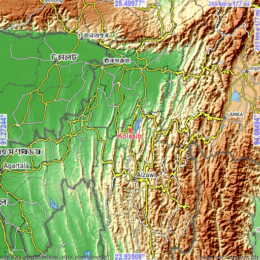
These maps also provides idea of topography and contour of this city, they are displayed at different zoom levels. More info about maps, scale and edge coordinates you can find below images.
| \ | Map #1 | Map #2 | Topo.Map |
| Scale [m] | 49..740 m | 42..778 m | × |
| Scale [ft] | 161..2428 ft | 138..2552 ft | × |
| Average | 291.3 m = 956 ft | 207.9 m = 682 ft | × |
| Width | 8.91 km = 5.5 mi | 17.82 km = 11.1 mi | 285.2 km = 177.2 mi |
| Height | 8.91 km = 5.5 mi | 17.82 km = 11.1 mi | 285.2 km = 177.2 mi |
| ↑Max Latitude | 24.26395° | 24.304007° | 25.49977° |
| Latitude at center | 24.22388° | 24.22388° | 24.22388° |
| ↓Min Latitude | 24.183798° | 24.143703° | 22.93508° |
| ← Min Longitude | 92.634745° | 92.590799° | 91.27244° |
| Longitude center | 92.67869° | 92.67869° | 92.67869° |
| →Max Longitude | 92.722635° | 92.766581° | 94.08494° |
Nearby cities:
Cities around Kolasib sort by population:
• Aizawl elevation 1080 m
55.2 km,  175°
175°
• Silchar 24 m
68.2 km,  10°
10°
• Dharmanagar 32 m
54.3 km,  287°
287°
• Hailākāndi 30 m
52.5 km,  346°
346°
• Kailāshahar 32 m
69.4 km,  279°
279°
• Lakhipur 35 m
71.5 km,  27°
27°
• Sāitlaw 799 m
29.9 km,  200°
200°
• Lāla 34 m
37.3 km, 350°
• Mamit 870 m
38.2 km,  210°
210°
• Sairang 111 m
46.1 km, 183°
• Darlawn 1119 m
34.2 km,  133°
133°
• Pherzawl 1017 m
51.9 km,  85°
85°
Multilingual:
 En español:
Kolasib elevación 661 m.
 En France:
Kolasib élévation 661 m.


Sources and notes:
- [note 1] Map square and city borders are not equal. Map elevation data is calculated only from area inside that square.
- [src 1] Elevation data from geonames database provided with same terms of usage.
- [src 2] The elevation map of Kolasib is generated using elevation data from NASA's 3 arcsec (90m) resolution SRTM data.
- [src 3] Base (background) map © OpenStreetMap contributors tiles are generated by Geofabrik and OpenTopoMap.
Copyright & License:
This Kolasib Elevation Map is licensed under CC BY-SA. You may reuse any part from this page, if you give a proper credit by linking to this URL:
 More info on terms of use page.