Pherzawl elevation
Pherzawl (Manipur), India elevation is 1017 meters and Pherzawl elevation in feet is 3337 ft above sea level [src 1]. Pherzawl is a seat of a second-order administrative division (feature code) with elevation that is 724 meters (2375 ft) bigger than average city elevation in India.
Below is the Elevation map of Pherzawl, which displays elevation range with different colors. Scale of the first map is from 271 to 1177 m (889 to 3862 ft) with average elevation of 658.8 meters (=2161 ft) [note 1]
These maps also provides idea of topography and contour of this city, they are displayed at different zoom levels. More info about maps, scale and edge coordinates you can find below images.
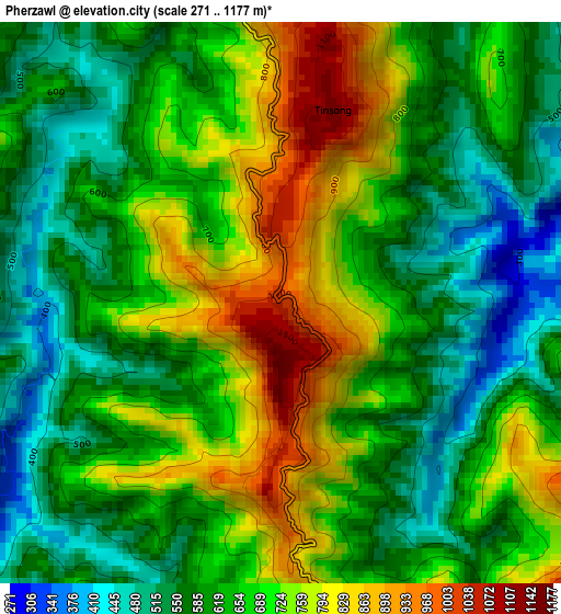
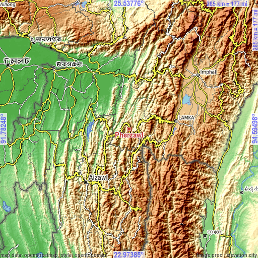
| \ | Map #1 | Topo.Map |
| Scale [m] | 271..1177 m | × |
| Scale [ft] | 889..3862 ft | × |
| Average | 658.8 m = 2161 ft | × |
| Width | 8.91 km = 5.5 mi | 285.1 km = 177.2 mi |
| Height | 8.91 km = 5.5 mi | 285.1 km = 177.2 mi |
| ↑Max Latitude | 24.302327° | 25.53776° |
| Latitude at center | 24.26227° | 24.26227° |
| ↓Min Latitude | 24.2222° | 22.97385° |
| ← Min Longitude | 93.144785° | 91.78248° |
| Longitude center | 93.18873° | 93.18873° |
| →Max Longitude | 93.232675° | 94.59498° |
Nearby cities:
Cities around Pherzawl sort by population:
• Aizawl elevation 1080 m
76.2 km,  218°
218°
• Silchar 24 m
74.2 km,  327°
327°
• Churāchāndpur 944 m
49.4 km,  80°
80°
• Kolasib 661 m
51.9 km,  265°
265°
• Moirāng 773 m
65.1 km,  66°
66°
• Lakhipur 35 m
61.7 km,  342°
342°
• Sāitlaw 799 m
70.2 km,  242°
242°
• Lāla 34 m
66.5 km,  299°
299°
• Sairang 111 m
74.1 km,  227°
227°
• Darlawn 1119 m
38.5 km, 224°
• Bishnupur 809 m
70.9 km,  54°
54°
• Jiribam 33 m
60.6 km,  353°
353°
Multilingual:
 En español:
Pherzawl elevación 1017 m.
 En France:
Pherzawl élévation 1017 m.
 Auf Deutsch:
Pherzawl höhe über dem Meeresspiegel ist 1017 m.

Sources and notes:
- [note 1] Map square and city borders are not equal. Map elevation data is calculated only from area inside that square.
- [src 1] Elevation data from geonames database provided with same terms of usage.
- [src 2] The elevation map of Pherzawl is generated using elevation data from NASA's 3 arcsec (90m) resolution SRTM data.
- [src 3] Base (background) map © OpenStreetMap contributors tiles are generated by Geofabrik and OpenTopoMap.
Copyright & License:
This Pherzawl Elevation Map is licensed under CC BY-SA. You may reuse any part from this page, if you give a proper credit by linking to this URL:
 More info on terms of use page.