Āmbāsa elevation
Āmbāsa (Tripura, Dhalai), India elevation is 81 meters and Āmbāsa elevation in feet is 266 ft above sea level [src 1]. Āmbāsa is a populated place (feature code) with elevation that is 212 meters (696 ft) smaller than average city elevation in India.
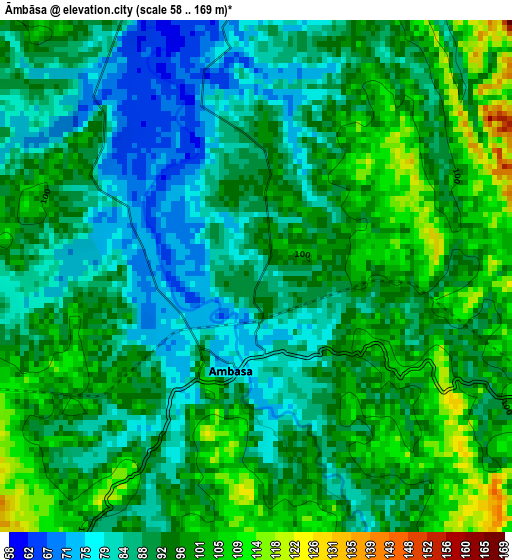
Below is the Elevation map of Āmbāsa, which displays elevation range with different colors. Scale of the first map is from 58 to 169 m (190 to 554 ft) with average elevation of 92.3 meters (=303 ft) [note 1]
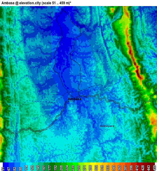
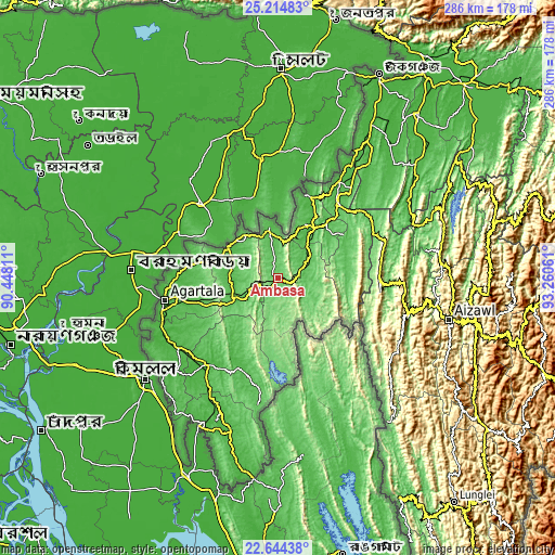
These maps also provides idea of topography and contour of this city, they are displayed at different zoom levels. More info about maps, scale and edge coordinates you can find below images.
| \ | Map #1 | Map #2 | Topo.Map |
| Scale [m] | 58..169 m | 51..459 m | × |
| Scale [ft] | 190..554 ft | 167..1506 ft | × |
| Average | 92.3 m = 303 ft | 123.8 m = 406 ft | × |
| Width | 8.93 km = 5.5 mi | 17.86 km = 11.1 mi | 285.8 km = 177.6 mi |
| Height | 8.93 km = 5.5 mi | 17.86 km = 11.1 mi | 285.8 km = 177.6 mi |
| ↑Max Latitude | 23.97616° | 24.016307° | 25.21483° |
| Latitude at center | 23.936° | 23.936° | 23.936° |
| ↓Min Latitude | 23.895828° | 23.855643° | 22.64438° |
| ← Min Longitude | 91.810415° | 91.766469° | 90.44811° |
| Longitude center | 91.85436° | 91.85436° | 91.85436° |
| →Max Longitude | 91.898305° | 91.942251° | 93.26061° |
Nearby cities:
Cities around Āmbāsa sort by population:
• Agartala elevation 15 m
59.5 km,  259°
259°
• Dharmanagar 32 m
57.4 km,  33°
33°
• Udaipur 28 m
58.6 km,  220°
220°
• Kailāshahar 32 m
46.6 km,  19°
19°
• Khowai 33 m
30.4 km,  301°
301°
• Barjala 43 m
61.8 km,  235°
235°
• Amarpur 42 m
49.8 km,  203°
203°
• Rānīr Bāzār 23 m
50.9 km, 257°
• Sāitlaw 799 m
73.3 km,  86°
86°
• Mamit 870 m
64.6 km, 90°
• Kamalpur 40 m
29 km,  355°
355°
• Bishramganj 39 m
63.6 km,  234°
234°
Multilingual:
 En español:
Āmbāsa elevación 81 m.
 En France:
Āmbāsa élévation 81 m.


Sources and notes:
- [note 1] Map square and city borders are not equal. Map elevation data is calculated only from area inside that square.
- [src 1] Elevation data from geonames database provided with same terms of usage.
- [src 2] The elevation map of Āmbāsa is generated using elevation data from NASA's 3 arcsec (90m) resolution SRTM data.
- [src 3] Base (background) map © OpenStreetMap contributors tiles are generated by Geofabrik and OpenTopoMap.
Copyright & License:
This Āmbāsa Elevation Map is licensed under CC BY-SA. You may reuse any part from this page, if you give a proper credit by linking to this URL:
 More info on terms of use page.