Anekal elevation
Anekal (Karnataka, Bangalore Urban), India elevation is 927 meters and Anekal elevation in feet is 3041 ft above sea level [src 1]. Anekal is a populated place (feature code) with elevation that is 634 meters (2080 ft) bigger than average city elevation in India.
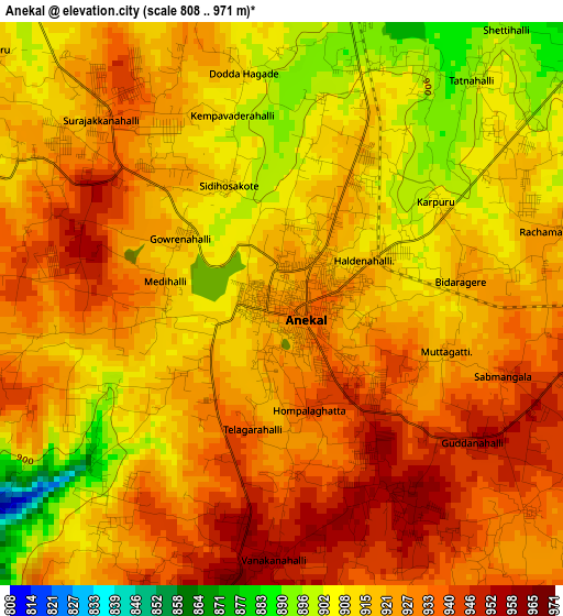
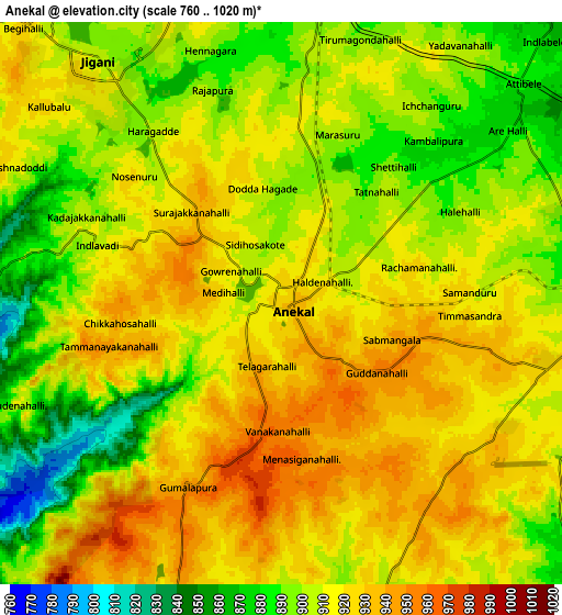
Below is the Elevation map of Anekal, which displays elevation range with different colors. Scale of the first map is from 808 to 971 m (2651 to 3186 ft) with average elevation of 921.1 meters (=3022 ft) [note 1]
These maps also provides idea of topography and contour of this city, they are displayed at different zoom levels. More info about maps, scale and edge coordinates you can find below images.
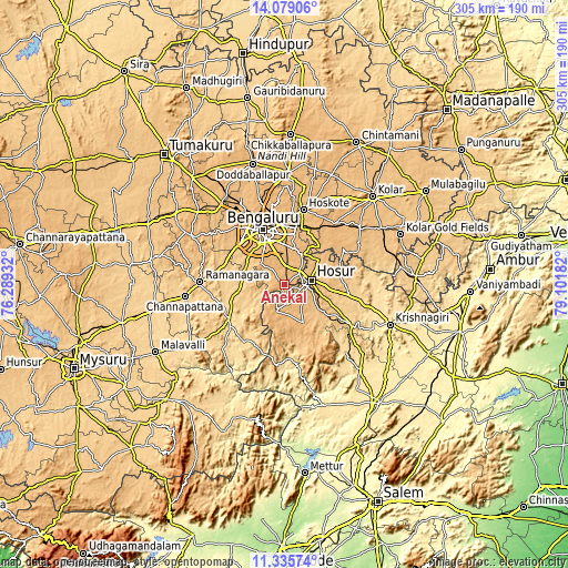
| \ | Map #1 | Map #2 | Topo.Map |
| Scale [m] | 808..971 m | 760..1020 m | × |
| Scale [ft] | 2651..3186 ft | 2493..3346 ft | × |
| Average | 921.1 m = 3022 ft | 909.9 m = 2985 ft | × |
| Width | 9.53 km = 5.9 mi | 19.07 km = 11.8 mi | 305 km = 189.5 mi |
| Height | 9.53 km = 5.9 mi | 19.07 km = 11.8 mi | 305.1 km = 189.6 mi |
| ↑Max Latitude | 12.753965° | 12.796822° | 14.07906° |
| Latitude at center | 12.7111° | 12.7111° | 12.7111° |
| ↓Min Latitude | 12.668228° | 12.625349° | 11.33574° |
| ← Min Longitude | 77.651625° | 77.607679° | 76.28932° |
| Longitude center | 77.69557° | 77.69557° | 77.69557° |
| →Max Longitude | 77.739515° | 77.783461° | 79.10182° |
Nearby cities:
Cities around Anekal sort by population:
• Bengaluru elevation 914 m
31 km,  339°
339°
• Yelahanka 903 m
44.6 km,  346°
346°
• Hosūr 871 m
15.1 km,  79°
79°
• Closepet 695 m
44.9 km,  271°
271°
• Channapatna 669 m
53.4 km,  262°
262°
• Kānkānhalli 639 m
35 km,  238°
238°
• Hoskote 884 m
41.5 km,  15°
15°
• Mālūr 914 m
41.8 km,  38°
38°
• Denkanikota 886 m
22.5 km,  153°
153°
• Kelamangalam 796 m
20.8 km,  125°
125°
• Mārāndahalli 585 m
49 km,  137°
137°
• Dasarahalli 877 m
45.6 km, 18°
Multilingual:
 En español:
Anekal elevación 927 m.
 En France:
Anekal élévation 927 m.


Sources and notes:
- [note 1] Map square and city borders are not equal. Map elevation data is calculated only from area inside that square.
- [src 1] Elevation data from geonames database provided with same terms of usage.
- [src 2] The elevation map of Anekal is generated using elevation data from NASA's 3 arcsec (90m) resolution SRTM data.
- [src 3] Base (background) map © OpenStreetMap contributors tiles are generated by Geofabrik and OpenTopoMap.
Copyright & License:
This Anekal Elevation Map is licensed under CC BY-SA. You may reuse any part from this page, if you give a proper credit by linking to this URL:
 More info on terms of use page.