Mālūr elevation
Mālūr (Karnataka, Kolar), India elevation is 914 meters and Mālūr elevation in feet is 2999 ft above sea level [src 1]. Mālūr is a populated place (feature code) with elevation that is 621 meters (2037 ft) bigger than average city elevation in India.
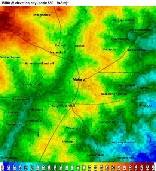
Below is the Elevation map of Mālūr, which displays elevation range with different colors. Scale of the first map is from 860 to 946 m (2822 to 3104 ft) with average elevation of 899.7 meters (=2952 ft) [note 1]
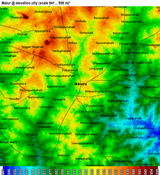
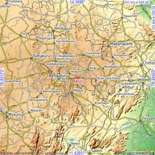
These maps also provides idea of topography and contour of this city, they are displayed at different zoom levels. More info about maps, scale and edge coordinates you can find below images.
| \ | Map #1 | Map #2 | Topo.Map |
| Scale [m] | 860..946 m | 841..958 m | × |
| Scale [ft] | 2822..3104 ft | 2759..3143 ft | × |
| Average | 899.7 m = 2952 ft | 897.1 m = 2943 ft | × |
| Width | 9.52 km = 5.9 mi | 19.04 km = 11.8 mi | 304.7 km = 189.3 mi |
| Height | 9.52 km = 5.9 mi | 19.04 km = 11.8 mi | 304.7 km = 189.3 mi |
| ↑Max Latitude | 13.046035° | 13.088842° | 14.3695° |
| Latitude at center | 13.00322° | 13.00322° | 13.00322° |
| ↓Min Latitude | 12.960398° | 12.917568° | 11.62937° |
| ← Min Longitude | 77.894035° | 77.850089° | 76.53173° |
| Longitude center | 77.93798° | 77.93798° | 77.93798° |
| →Max Longitude | 77.981925° | 78.025871° | 79.34423° |
Nearby cities:
Cities around Mālūr sort by population:
• Bengaluru elevation 914 m
37.5 km,  264°
264°
• Robertsonpet 851 m
36.9 km,  98°
98°
• Kolār 848 m
25.6 km,  54°
54°
• Yelahanka 903 m
38.6 km,  286°
286°
• Hosūr 871 m
31.8 km,  201°
201°
• Sidlaghatta 901 m
43.6 km,  349°
349°
• Bangarapet 826 m
26 km,  92°
92°
• Hoskote 884 m
16.9 km,  296°
296°
• Anekal 927 m
41.8 km,  218°
218°
• Vadigenhalli 886 m
35.9 km,  335°
335°
• Devanhalli 899 m
36.5 km,  317°
317°
• Dasarahalli 877 m
15.7 km,  312°
312°
Multilingual:
 En español:
Mālūr elevación 914 m.
 En France:
Mālūr élévation 914 m.


Sources and notes:
- [note 1] Map square and city borders are not equal. Map elevation data is calculated only from area inside that square.
- [src 1] Elevation data from geonames database provided with same terms of usage.
- [src 2] The elevation map of Mālūr is generated using elevation data from NASA's 3 arcsec (90m) resolution SRTM data.
- [src 3] Base (background) map © OpenStreetMap contributors tiles are generated by Geofabrik and OpenTopoMap.
Copyright & License:
This Mālūr Elevation Map is licensed under CC BY-SA. You may reuse any part from this page, if you give a proper credit by linking to this URL:
 More info on terms of use page.