Closepet elevation
Closepet (Karnataka, Ramanagara), India elevation is 695 meters and Closepet elevation in feet is 2280 ft above sea level [src 1]. Closepet is a populated place (feature code) with elevation that is 402 meters (1319 ft) bigger than average city elevation in India.
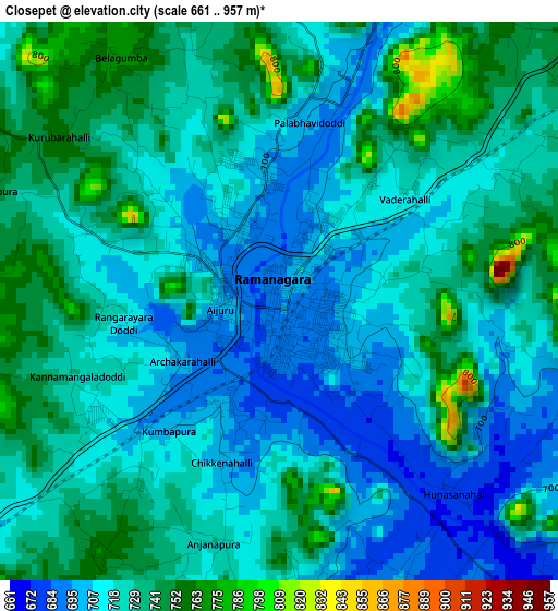
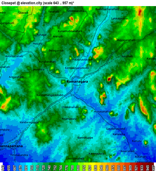
Below is the Elevation map of Closepet, which displays elevation range with different colors. Scale of the first map is from 661 to 957 m (2169 to 3140 ft) with average elevation of 722.6 meters (=2371 ft) [note 1]
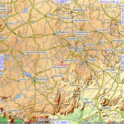
These maps also provides idea of topography and contour of this city, they are displayed at different zoom levels. More info about maps, scale and edge coordinates you can find below images.
| \ | Map #1 | Map #2 | Topo.Map |
| Scale [m] | 661..957 m | 643..957 m | × |
| Scale [ft] | 2169..3140 ft | 2110..3140 ft | × |
| Average | 722.6 m = 2371 ft | 730.3 m = 2396 ft | × |
| Width | 9.53 km = 5.9 mi | 19.07 km = 11.8 mi | 305 km = 189.5 mi |
| Height | 9.53 km = 5.9 mi | 19.07 km = 11.8 mi | 305 km = 189.5 mi |
| ↑Max Latitude | 12.764673° | 12.807528° | 14.08971° |
| Latitude at center | 12.72181° | 12.72181° | 12.72181° |
| ↓Min Latitude | 12.67894° | 12.636063° | 11.3465° |
| ← Min Longitude | 77.237545° | 77.193599° | 75.87524° |
| Longitude center | 77.28149° | 77.28149° | 77.28149° |
| →Max Longitude | 77.325435° | 77.369381° | 78.68774° |
Nearby cities:
Cities around Closepet sort by population:
• Bengaluru elevation 914 m
43.8 km,  50°
50°
• Mandya 681 m
47.2 km,  241°
241°
• Yelahanka 903 m
54.2 km,  39°
39°
• Channapatna 669 m
11.3 km,  226°
226°
• Kānkānhalli 639 m
24.6 km,  142°
142°
• Malavalli 621 m
44.4 km,  212°
212°
• Anekal 927 m
44.9 km,  91°
91°
• Kunigal 778 m
43.5 km,  320°
320°
• Nelamangala 898 m
43.7 km,  16°
16°
• Maddūr 643 m
30.1 km, 239°
• Māgadi 879 m
26.9 km,  346°
346°
• Nāgamangala 790 m
58.2 km,  280°
280°
Multilingual:
 En español:
Closepet elevación 695 m.
 En France:
Closepet élévation 695 m.
 Auf Deutsch:
Closepet höhe über dem Meeresspiegel ist 695 m.

Sources and notes:
- [note 1] Map square and city borders are not equal. Map elevation data is calculated only from area inside that square.
- [src 1] Elevation data from geonames database provided with same terms of usage.
- [src 2] The elevation map of Closepet is generated using elevation data from NASA's 3 arcsec (90m) resolution SRTM data.
- [src 3] Base (background) map © OpenStreetMap contributors tiles are generated by Geofabrik and OpenTopoMap.
Copyright & License:
This Closepet Elevation Map is licensed under CC BY-SA. You may reuse any part from this page, if you give a proper credit by linking to this URL:
 More info on terms of use page.