Ausa elevation
Ausa (Maharashtra, Latur), India elevation is 637 meters and Ausa elevation in feet is 2090 ft above sea level [src 1]. Ausa is a populated place (feature code) with elevation that is 344 meters (1129 ft) bigger than average city elevation in India.
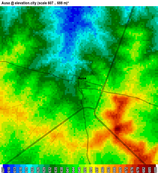
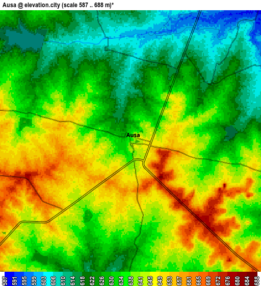
Below is the Elevation map of Ausa, which displays elevation range with different colors. Scale of the first map is from 607 to 688 m (1991 to 2257 ft) with average elevation of 642.2 meters (=2107 ft) [note 1]
These maps also provides idea of topography and contour of this city, they are displayed at different zoom levels. More info about maps, scale and edge coordinates you can find below images.
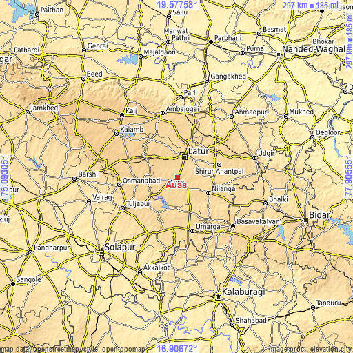
| \ | Map #1 | Map #2 | Topo.Map |
| Scale [m] | 607..688 m | 587..688 m | × |
| Scale [ft] | 1991..2257 ft | 1926..2257 ft | × |
| Average | 642.2 m = 2107 ft | 634.6 m = 2082 ft | × |
| Width | 9.28 km = 5.8 mi | 18.56 km = 11.5 mi | 297 km = 184.5 mi |
| Height | 9.28 km = 5.8 mi | 18.56 km = 11.5 mi | 297 km = 184.5 mi |
| ↑Max Latitude | 18.28901° | 18.330731° | 19.57758° |
| Latitude at center | 18.24728° | 18.24728° | 18.24728° |
| ↓Min Latitude | 18.20554° | 18.163789° | 16.90672° |
| ← Min Longitude | 76.455355° | 76.411409° | 75.09305° |
| Longitude center | 76.4993° | 76.4993° | 76.4993° |
| →Max Longitude | 76.543245° | 76.587191° | 77.90555° |
Nearby cities:
Cities around Ausa sort by population:
• Latur elevation 638 m
18.2 km,  23°
23°
• Udgīr 643 m
67.2 km,  76°
76°
• Parli Vaijnāth 463 m
67.2 km,  2°
2°
• Osmanabad 665 m
49.2 km,  261°
261°
• Ambājogāi 633 m
55.3 km,  347°
347°
• Basavakalyān 631 m
63.1 km,  131°
131°
• Ahmadpur 526 m
68.8 km,  42°
42°
• Tuljāpur 647 m
52.6 km,  239°
239°
• Nilanga 607 m
30.5 km,  118°
118°
• Umarga 580 m
47.3 km,  163°
163°
• Moram 586 m
51.1 km,  183°
183°
• Naldurg 568 m
53.1 km,  205°
205°
Multilingual:
 En español:
Ausa elevación 637 m.
 En France:
Ausa élévation 637 m.


Sources and notes:
- [note 1] Map square and city borders are not equal. Map elevation data is calculated only from area inside that square.
- [src 1] Elevation data from geonames database provided with same terms of usage.
- [src 2] The elevation map of Ausa is generated using elevation data from NASA's 3 arcsec (90m) resolution SRTM data.
- [src 3] Base (background) map © OpenStreetMap contributors tiles are generated by Geofabrik and OpenTopoMap.
Copyright & License:
This Ausa Elevation Map is licensed under CC BY-SA. You may reuse any part from this page, if you give a proper credit by linking to this URL:
 More info on terms of use page.