Naldurg elevation
Naldurg (Maharashtra, Osmanabad), India elevation is 568 meters and Naldurg elevation in feet is 1864 ft above sea level [src 1]. Naldurg is a populated place (feature code) with elevation that is 275 meters (902 ft) bigger than average city elevation in India.
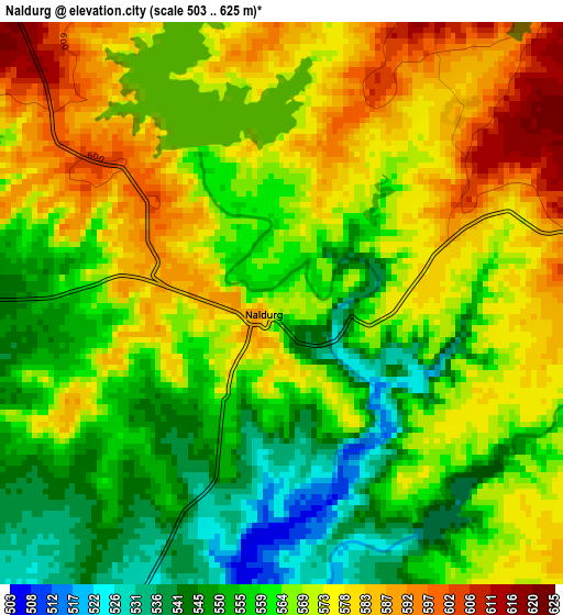
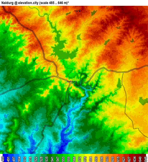
Below is the Elevation map of Naldurg, which displays elevation range with different colors. Scale of the first map is from 503 to 625 m (1650 to 2051 ft) with average elevation of 566.4 meters (=1858 ft) [note 1]
These maps also provides idea of topography and contour of this city, they are displayed at different zoom levels. More info about maps, scale and edge coordinates you can find below images.
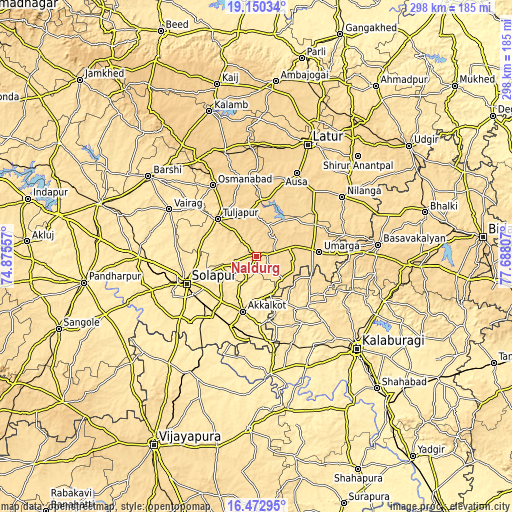
| \ | Map #1 | Map #2 | Topo.Map |
| Scale [m] | 503..625 m | 485..646 m | × |
| Scale [ft] | 1650..2051 ft | 1591..2119 ft | × |
| Average | 566.4 m = 1858 ft | 570 m = 1870 ft | × |
| Width | 9.3 km = 5.8 mi | 18.61 km = 11.6 mi | 297.7 km = 185 mi |
| Height | 9.3 km = 5.8 mi | 18.61 km = 11.6 mi | 297.7 km = 185 mi |
| ↑Max Latitude | 17.858503° | 17.900326° | 19.15034° |
| Latitude at center | 17.81667° | 17.81667° | 17.81667° |
| ↓Min Latitude | 17.774827° | 17.732975° | 16.47295° |
| ← Min Longitude | 76.237875° | 76.193929° | 74.87557° |
| Longitude center | 76.28182° | 76.28182° | 76.28182° |
| →Max Longitude | 76.325765° | 76.369711° | 77.68807° |
Nearby cities:
Cities around Naldurg sort by population:
• Solāpur elevation 473 m
42.5 km,  247°
247°
• Osmanabad 665 m
48 km,  327°
327°
• Akalkot 471 m
33.4 km,  193°
193°
• Aland 499 m
41.4 km,  132°
132°
• Tuljāpur 647 m
30.9 km,  313°
313°
• Nilanga 607 m
60 km,  56°
56°
• Ausa 637 m
53.1 km,  25°
25°
• Umarga 580 m
36.2 km,  86°
86°
• Moram 586 m
20.3 km,  99°
99°
• Dudhani 445 m
51.8 km,  169°
169°
• Kāti 515 m
44.6 km,  291°
291°
• Maindargi 449 m
40 km,  178°
178°
Multilingual:
 En español:
Naldurg elevación 568 m.
 En France:
Naldurg élévation 568 m.


Sources and notes:
- [note 1] Map square and city borders are not equal. Map elevation data is calculated only from area inside that square.
- [src 1] Elevation data from geonames database provided with same terms of usage.
- [src 2] The elevation map of Naldurg is generated using elevation data from NASA's 3 arcsec (90m) resolution SRTM data.
- [src 3] Base (background) map © OpenStreetMap contributors tiles are generated by Geofabrik and OpenTopoMap.
Copyright & License:
This Naldurg Elevation Map is licensed under CC BY-SA. You may reuse any part from this page, if you give a proper credit by linking to this URL:
 More info on terms of use page.