Badvel elevation
Badvel (Andhra Pradesh, Cuddapah), India elevation is 139 meters and Badvel elevation in feet is 456 ft above sea level [src 1]. Badvel is a populated place (feature code) with elevation that is 154 meters (505 ft) smaller than average city elevation in India.
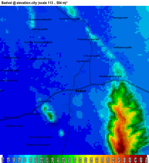
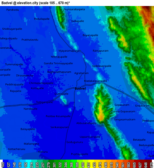
Below is the Elevation map of Badvel, which displays elevation range with different colors. Scale of the first map is from 113 to 504 m (371 to 1654 ft) with average elevation of 155.2 meters (=509 ft) [note 1]
These maps also provides idea of topography and contour of this city, they are displayed at different zoom levels. More info about maps, scale and edge coordinates you can find below images.
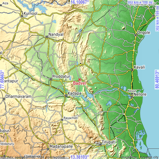
| \ | Map #1 | Map #2 | Topo.Map |
| Scale [m] | 113..504 m | 105..670 m | × |
| Scale [ft] | 371..1654 ft | 344..2198 ft | × |
| Average | 155.2 m = 509 ft | 173.3 m = 569 ft | × |
| Width | 9.45 km = 5.9 mi | 18.9 km = 11.7 mi | 302.4 km = 187.9 mi |
| Height | 9.45 km = 5.9 mi | 18.9 km = 11.7 mi | 302.4 km = 187.9 mi |
| ↑Max Latitude | 14.787594° | 14.83008° | 16.10067° |
| Latitude at center | 14.7451° | 14.7451° | 14.7451° |
| ↓Min Latitude | 14.702598° | 14.660087° | 13.38103° |
| ← Min Longitude | 79.018935° | 78.974989° | 77.65663° |
| Longitude center | 79.06288° | 79.06288° | 79.06288° |
| →Max Longitude | 79.106825° | 79.150771° | 80.46913° |
Nearby cities:
Cities around Badvel sort by population:
• Proddatūr elevation 160 m
55.4 km,  270°
270°
• Cuddapah 135 m
39.2 km,  221°
221°
• Rāyachoti 361 m
83.6 km,  203°
203°
• Chinnachowk 135 m
38.7 km, 219°
• Jammalamadugu 188 m
73.9 km,  278°
278°
• Rāzampeta 139 m
62 km,  170°
170°
• Giddalūr 265 m
71.5 km,  348°
348°
• Erraguntla 169 m
57.5 km,  258°
258°
• Kanigiri 113 m
87.6 km,  32°
32°
• Kāmalāpuram 141 m
45.4 km,  248°
248°
• Nāgireddipalli 150 m
53 km,  175°
175°
• Diguvametta 309 m
76.5 km,  340°
340°
Multilingual:
 En español:
Badvel elevación 139 m.
 En France:
Badvel élévation 139 m.


Sources and notes:
- [note 1] Map square and city borders are not equal. Map elevation data is calculated only from area inside that square.
- [src 1] Elevation data from geonames database provided with same terms of usage.
- [src 2] The elevation map of Badvel is generated using elevation data from NASA's 3 arcsec (90m) resolution SRTM data.
- [src 3] Base (background) map © OpenStreetMap contributors tiles are generated by Geofabrik and OpenTopoMap.
Copyright & License:
This Badvel Elevation Map is licensed under CC BY-SA. You may reuse any part from this page, if you give a proper credit by linking to this URL:
 More info on terms of use page.