Kanigiri elevation
Kanigiri (Andhra Pradesh, Prakasam), India elevation is 113 meters and Kanigiri elevation in feet is 371 ft above sea level [src 1]. Kanigiri is a populated place (feature code) with elevation that is 180 meters (591 ft) smaller than average city elevation in India.
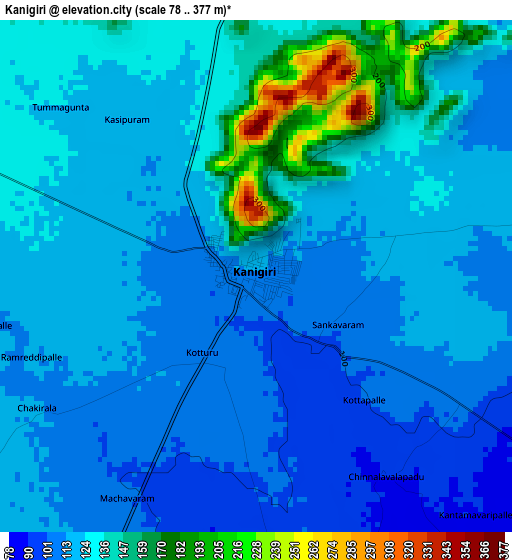
Below is the Elevation map of Kanigiri, which displays elevation range with different colors. Scale of the first map is from 78 to 377 m (256 to 1237 ft) with average elevation of 124 meters (=407 ft) [note 1]
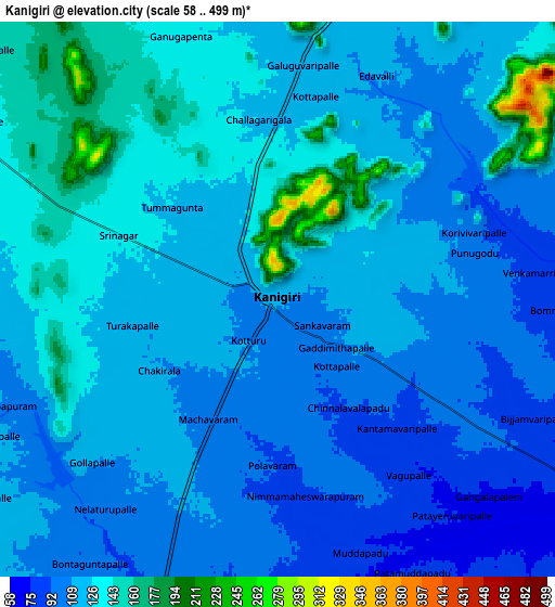
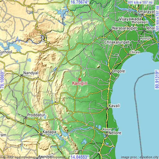
These maps also provides idea of topography and contour of this city, they are displayed at different zoom levels. More info about maps, scale and edge coordinates you can find below images.
| \ | Map #1 | Map #2 | Topo.Map |
| Scale [m] | 78..377 m | 58..499 m | × |
| Scale [ft] | 256..1237 ft | 190..1637 ft | × |
| Average | 124 m = 407 ft | 119.1 m = 391 ft | × |
| Width | 9.42 km = 5.9 mi | 18.84 km = 11.7 mi | 301.5 km = 187.3 mi |
| Height | 9.42 km = 5.9 mi | 18.84 km = 11.7 mi | 301.5 km = 187.3 mi |
| ↑Max Latitude | 15.447912° | 15.490265° | 16.75674° |
| Latitude at center | 15.40555° | 15.40555° | 15.40555° |
| ↓Min Latitude | 15.363179° | 15.3208° | 14.04553° |
| ← Min Longitude | 79.462995° | 79.419049° | 78.10069° |
| Longitude center | 79.50694° | 79.50694° | 79.50694° |
| →Max Longitude | 79.550885° | 79.594831° | 80.91319° |
Nearby cities:
Cities around Kanigiri sort by population:
• Ongole elevation 28 m
58.6 km,  79°
79°
• Kāvali 18 m
75.5 km,  136°
136°
• Mārkāpur 158 m
44.7 km,  325°
325°
• Vinukonda 96 m
76.2 km,  19°
19°
• Kandukūr 22 m
47.5 km,  116°
116°
• Darsi 111 m
44.5 km, 24°
• Chemmumiahpet 132 m
58.2 km,  340°
340°
• Addanki 41 m
67.3 km,  47°
47°
• Giddalūr 265 m
62.4 km,  266°
266°
• Cumbum 193 m
46.8 km,  294°
294°
• Singarāyakonda 17 m
59.2 km,  109°
109°
• Diguvametta 309 m
72.7 km, 269°
Multilingual:
 En español:
Kanigiri elevación 113 m.
 En France:
Kanigiri élévation 113 m.
 Auf Deutsch:
Kanigiri höhe über dem Meeresspiegel ist 113 m.

Sources and notes:
- [note 1] Map square and city borders are not equal. Map elevation data is calculated only from area inside that square.
- [src 1] Elevation data from geonames database provided with same terms of usage.
- [src 2] The elevation map of Kanigiri is generated using elevation data from NASA's 3 arcsec (90m) resolution SRTM data.
- [src 3] Base (background) map © OpenStreetMap contributors tiles are generated by Geofabrik and OpenTopoMap.
Copyright & License:
This Kanigiri Elevation Map is licensed under CC BY-SA. You may reuse any part from this page, if you give a proper credit by linking to this URL:
 More info on terms of use page.