Rāyachoti elevation
Rāyachoti (Andhra Pradesh, Cuddapah), India elevation is 361 meters and Rāyachoti elevation in feet is 1184 ft above sea level [src 1]. Rāyachoti is a populated place (feature code) with elevation that is 68 meters (223 ft) bigger than average city elevation in India.
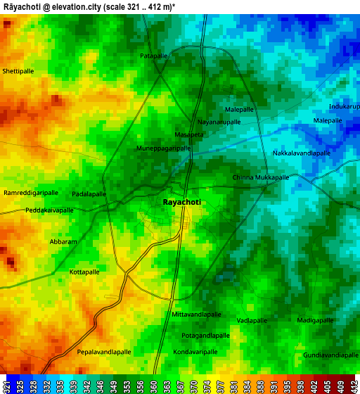
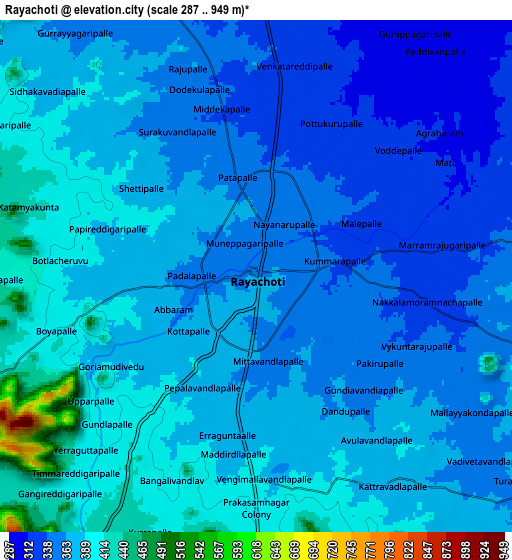
Below is the Elevation map of Rāyachoti, which displays elevation range with different colors. Scale of the first map is from 321 to 412 m (1053 to 1352 ft) with average elevation of 358.8 meters (=1177 ft) [note 1]
These maps also provides idea of topography and contour of this city, they are displayed at different zoom levels. More info about maps, scale and edge coordinates you can find below images.
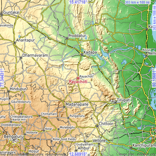
| \ | Map #1 | Map #2 | Topo.Map |
| Scale [m] | 321..412 m | 287..949 m | × |
| Scale [ft] | 1053..1352 ft | 942..3114 ft | × |
| Average | 358.8 m = 1177 ft | 371.1 m = 1218 ft | × |
| Width | 9.48 km = 5.9 mi | 18.96 km = 11.8 mi | 303.3 km = 188.5 mi |
| Height | 9.48 km = 5.9 mi | 18.96 km = 11.8 mi | 303.4 km = 188.5 mi |
| ↑Max Latitude | 14.099855° | 14.142473° | 15.41718° |
| Latitude at center | 14.05723° | 14.05723° | 14.05723° |
| ↓Min Latitude | 14.014597° | 13.971956° | 12.68915° |
| ← Min Longitude | 78.706615° | 78.662669° | 77.34431° |
| Longitude center | 78.75056° | 78.75056° | 78.75056° |
| →Max Longitude | 78.794505° | 78.838451° | 80.15681° |
Nearby cities:
Cities around Rāyachoti sort by population:
• Cuddapah elevation 135 m
47.7 km,  9°
9°
• Madanapalle 694 m
62.4 km,  205°
205°
• Kadiri 519 m
64 km,  275°
275°
• Chinnachowk 135 m
47.4 km, 11°
• Pulivendla 273 m
69.6 km,  305°
305°
• Rāzampeta 139 m
46.6 km,  70°
70°
• Erraguntla 169 m
68.5 km,  340°
340°
• Pākāla 367 m
78.2 km,  149°
149°
• Tirumala 858 m
76.9 km,  122°
122°
• Kāmalāpuram 141 m
60.8 km,  351°
351°
• Narasingāpuram 206 m
79 km,  129°
129°
• Nāgireddipalli 150 m
44.6 km,  57°
57°
Multilingual:
 En español:
Rāyachoti elevación 361 m.
 En France:
Rāyachoti élévation 361 m.
 Auf Deutsch:
Rāyachoti höhe über dem Meeresspiegel ist 361 m.

Sources and notes:
- [note 1] Map square and city borders are not equal. Map elevation data is calculated only from area inside that square.
- [src 1] Elevation data from geonames database provided with same terms of usage.
- [src 2] The elevation map of Rāyachoti is generated using elevation data from NASA's 3 arcsec (90m) resolution SRTM data.
- [src 3] Base (background) map © OpenStreetMap contributors tiles are generated by Geofabrik and OpenTopoMap.
Copyright & License:
This Rāyachoti Elevation Map is licensed under CC BY-SA. You may reuse any part from this page, if you give a proper credit by linking to this URL:
 More info on terms of use page.