Madanapalle elevation
Madanapalle (Andhra Pradesh, Chittoor), India elevation is 694 meters and Madanapalle elevation in feet is 2277 ft above sea level [src 1]. Madanapalle is a populated place (feature code) with elevation that is 401 meters (1316 ft) bigger than average city elevation in India.
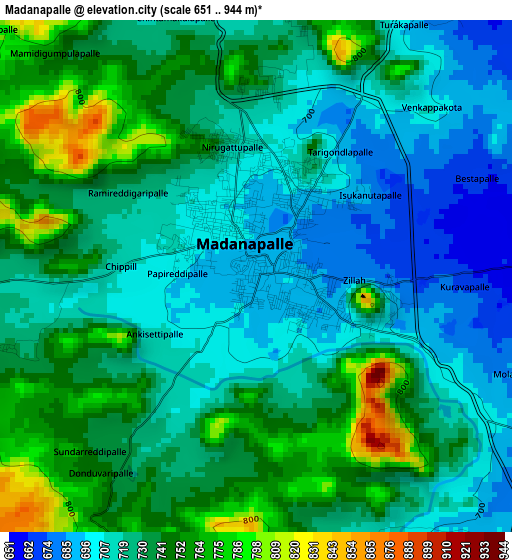
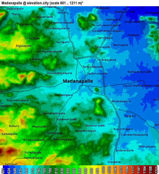
Below is the Elevation map of Madanapalle, which displays elevation range with different colors. Scale of the first map is from 651 to 944 m (2136 to 3097 ft) with average elevation of 728.5 meters (=2390 ft) [note 1]
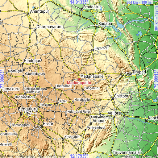
These maps also provides idea of topography and contour of this city, they are displayed at different zoom levels. More info about maps, scale and edge coordinates you can find below images.
| \ | Map #1 | Map #2 | Topo.Map |
| Scale [m] | 651..944 m | 601..1211 m | × |
| Scale [ft] | 2136..3097 ft | 1972..3973 ft | × |
| Average | 728.5 m = 2390 ft | 754.3 m = 2475 ft | × |
| Width | 9.5 km = 5.9 mi | 19 km = 11.8 mi | 304 km = 188.9 mi |
| Height | 9.5 km = 5.9 mi | 19 km = 11.8 mi | 304 km = 188.9 mi |
| ↑Max Latitude | 13.593018° | 13.635729° | 14.91335° |
| Latitude at center | 13.5503° | 13.5503° | 13.5503° |
| ↓Min Latitude | 13.507574° | 13.464841° | 12.17939° |
| ← Min Longitude | 78.458935° | 78.414989° | 77.09663° |
| Longitude center | 78.50288° | 78.50288° | 78.50288° |
| →Max Longitude | 78.546825° | 78.590771° | 79.90913° |
Nearby cities:
Cities around Madanapalle sort by population:
• Robertsonpet elevation 851 m
70.5 km,  200°
200°
• Kolār 848 m
61.1 km,  221°
221°
• Rāyachoti 361 m
62.4 km,  25°
25°
• Chintāmani 890 m
51.5 km,  251°
251°
• Sidlaghatta 901 m
71.3 km,  255°
255°
• Punganūru 730 m
21.7 km,  159°
159°
• Mulbāgal 849 m
44.6 km, 195°
• Peranāmpattu 369 m
72.4 km, 161°
• Bangarapet 826 m
71.4 km,  209°
209°
• Palmaner 675 m
47.1 km,  145°
145°
• Srīnivāspur 828 m
39.3 km,  233°
233°
• Pākāla 367 m
67.1 km,  99°
99°
Multilingual:
 En español:
Madanapalle elevación 694 m.
 En France:
Madanapalle élévation 694 m.
 Auf Deutsch:
Madanapalle höhe über dem Meeresspiegel ist 694 m.

Sources and notes:
- [note 1] Map square and city borders are not equal. Map elevation data is calculated only from area inside that square.
- [src 1] Elevation data from geonames database provided with same terms of usage.
- [src 2] The elevation map of Madanapalle is generated using elevation data from NASA's 3 arcsec (90m) resolution SRTM data.
- [src 3] Base (background) map © OpenStreetMap contributors tiles are generated by Geofabrik and OpenTopoMap.
Copyright & License:
This Madanapalle Elevation Map is licensed under CC BY-SA. You may reuse any part from this page, if you give a proper credit by linking to this URL:
 More info on terms of use page.