Bhadohi elevation
Bhadohi (Uttar Pradesh, Sant Ravi Das Nagar), India elevation is 94 meters and Bhadohi elevation in feet is 308 ft above sea level [src 1]. Bhadohi is a populated place (feature code) with elevation that is 199 meters (653 ft) smaller than average city elevation in India.
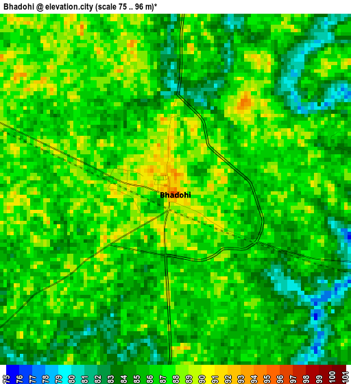
Below is the Elevation map of Bhadohi, which displays elevation range with different colors. Scale of the first map is from 75 to 96 m (246 to 315 ft) with average elevation of 85.9 meters (=282 ft) [note 1]
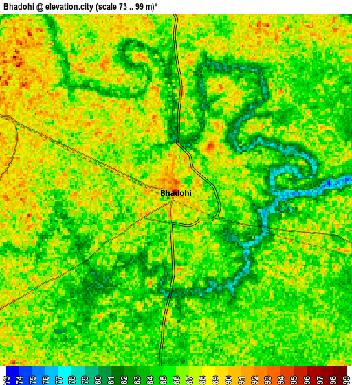
These maps also provides idea of topography and contour of this city, they are displayed at different zoom levels. More info about maps, scale and edge coordinates you can find below images.
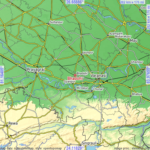
| \ | Map #1 | Map #2 | Topo.Map |
| Scale [m] | 75..96 m | 73..99 m | × |
| Scale [ft] | 246..315 ft | 240..325 ft | × |
| Average | 85.9 m = 282 ft | 85.9 m = 282 ft | × |
| Width | 8.83 km = 5.5 mi | 17.66 km = 11 mi | 282.5 km = 175.5 mi |
| Height | 8.83 km = 5.5 mi | 17.66 km = 11 mi | 282.5 km = 175.5 mi |
| ↑Max Latitude | 25.434952° | 25.474632° | 26.65886° |
| Latitude at center | 25.39526° | 25.39526° | 25.39526° |
| ↓Min Latitude | 25.355555° | 25.315836° | 24.11829° |
| ← Min Longitude | 82.526355° | 82.482409° | 81.16405° |
| Longitude center | 82.5703° | 82.5703° | 82.5703° |
| →Max Longitude | 82.614245° | 82.658191° | 83.97655° |
Nearby cities:
Cities around Bhadohi sort by population:
• Mirzāpur elevation 90 m
27.8 km,  181°
181°
• Jaunpur 85 m
41.5 km,  16°
16°
• Chunār 83 m
43.2 km,  133°
133°
• Machhlīshahr 98 m
36 km,  333°
333°
• Mariāhu 94 m
23.5 km,  8°
8°
• Suriānwān 91 m
17 km,  296°
296°
• Handiā 97 m
38.7 km,  264°
264°
• Kachhwa 82 m
25.5 km,  145°
145°
• Kirākat 87 m
43.9 km,  52°
52°
• Gyānpur 91 m
12.5 km,  236°
236°
• Barāgaon 89 m
25.1 km,  81°
81°
• Zafarābād 86 m
37.5 km,  25°
25°
Multilingual:
 En español:
Bhadohi elevación 94 m.
 En France:
Bhadohi élévation 94 m.


Sources and notes:
- [note 1] Map square and city borders are not equal. Map elevation data is calculated only from area inside that square.
- [src 1] Elevation data from geonames database provided with same terms of usage.
- [src 2] The elevation map of Bhadohi is generated using elevation data from NASA's 3 arcsec (90m) resolution SRTM data.
- [src 3] Base (background) map © OpenStreetMap contributors tiles are generated by Geofabrik and OpenTopoMap.
Copyright & License:
This Bhadohi Elevation Map is licensed under CC BY-SA. You may reuse any part from this page, if you give a proper credit by linking to this URL:
 More info on terms of use page.