Jaunpur elevation
Jaunpur (Uttar Pradesh), India elevation is 85 meters and Jaunpur elevation in feet is 279 ft above sea level [src 1]. Jaunpur is a populated place (feature code) with elevation that is 208 meters (682 ft) smaller than average city elevation in India.
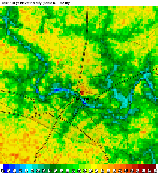
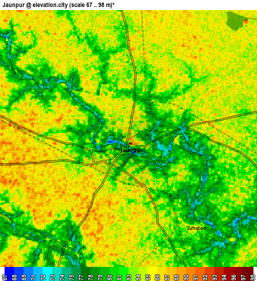
Below is the Elevation map of Jaunpur, which displays elevation range with different colors. Scale of the first map is from 67 to 98 m (220 to 322 ft) with average elevation of 82.1 meters (=269 ft) [note 1]
These maps also provides idea of topography and contour of this city, they are displayed at different zoom levels. More info about maps, scale and edge coordinates you can find below images.
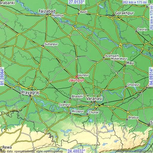
| \ | Map #1 | Map #2 | Topo.Map |
| Scale [m] | 67..98 m | 67..98 m | × |
| Scale [ft] | 220..322 ft | 220..322 ft | × |
| Average | 82.1 m = 269 ft | 83.2 m = 273 ft | × |
| Width | 8.8 km = 5.5 mi | 17.6 km = 10.9 mi | 281.6 km = 175 mi |
| Height | 8.8 km = 5.5 mi | 17.6 km = 10.9 mi | 281.7 km = 175 mi |
| ↑Max Latitude | 25.793134° | 25.832694° | 27.0133° |
| Latitude at center | 25.75356° | 25.75356° | 25.75356° |
| ↓Min Latitude | 25.713973° | 25.674373° | 24.48032° |
| ← Min Longitude | 82.642945° | 82.598999° | 81.28064° |
| Longitude center | 82.68689° | 82.68689° | 82.68689° |
| →Max Longitude | 82.730835° | 82.774781° | 84.09314° |
Nearby cities:
Cities around Jaunpur sort by population:
• Bhadohi elevation 94 m
41.5 km,  196°
196°
• Shāhganj 91 m
32.9 km,  359°
359°
• Machhlīshahr 98 m
28.6 km,  254°
254°
• Mariāhu 94 m
18.6 km,  206°
206°
• Suriānwān 91 m
41.9 km,  219°
219°
• Sarāi Mīr 90 m
38.2 km,  37°
37°
• Mehnagar 84 m
45.2 km,  72°
72°
• Kirākat 87 m
26.3 km,  119°
119°
• Nizāmābād 86 m
49.8 km,  48°
48°
• Barāgaon 89 m
38.3 km,  160°
160°
• Zafarābād 86 m
7.7 km,  142°
142°
• Phūlpur 89 m
40.7 km,  27°
27°
Multilingual:
 En español:
Jaunpur elevación 85 m.
 En France:
Jawnpur élévation 85 m.


Sources and notes:
- [note 1] Map square and city borders are not equal. Map elevation data is calculated only from area inside that square.
- [src 1] Elevation data from geonames database provided with same terms of usage.
- [src 2] The elevation map of Jaunpur is generated using elevation data from NASA's 3 arcsec (90m) resolution SRTM data.
- [src 3] Base (background) map © OpenStreetMap contributors tiles are generated by Geofabrik and OpenTopoMap.
Copyright & License:
This Jaunpur Elevation Map is licensed under CC BY-SA. You may reuse any part from this page, if you give a proper credit by linking to this URL:
 More info on terms of use page.