Bhānpura elevation
Bhānpura (Madhya Pradesh, Mandsaur), India elevation is 399 meters and Bhānpura elevation in feet is 1309 ft above sea level [src 1]. Bhānpura is a populated place (feature code) with elevation that is 106 meters (348 ft) bigger than average city elevation in India.
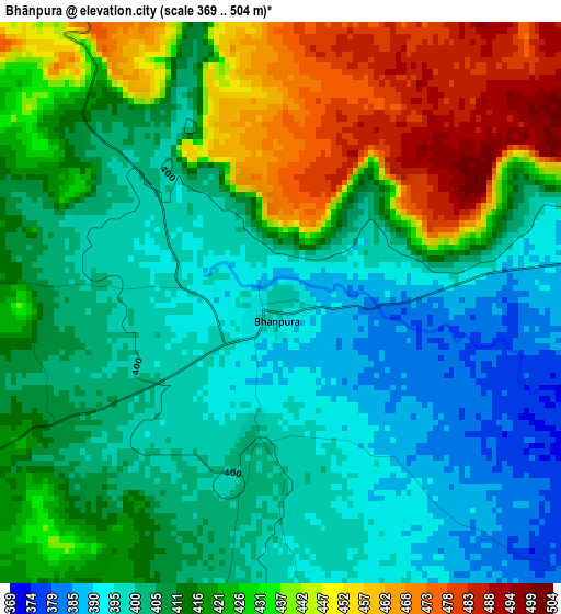
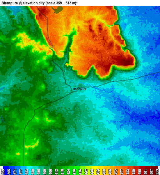
Below is the Elevation map of Bhānpura, which displays elevation range with different colors. Scale of the first map is from 369 to 504 m (1211 to 1654 ft) with average elevation of 416.7 meters (=1367 ft) [note 1]
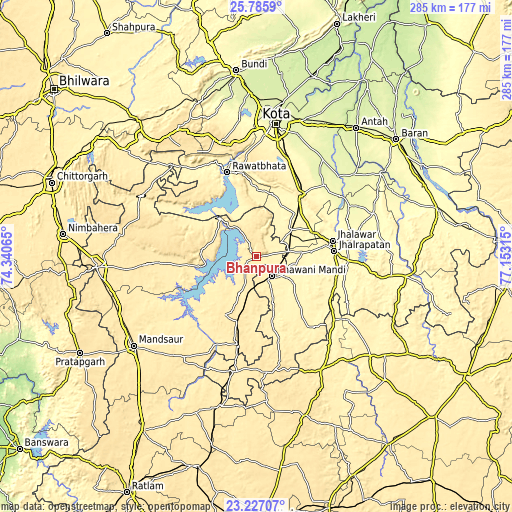
These maps also provides idea of topography and contour of this city, they are displayed at different zoom levels. More info about maps, scale and edge coordinates you can find below images.
| \ | Map #1 | Map #2 | Topo.Map |
| Scale [m] | 369..504 m | 359..513 m | × |
| Scale [ft] | 1211..1654 ft | 1178..1683 ft | × |
| Average | 416.7 m = 1367 ft | 412.3 m = 1353 ft | × |
| Width | 8.89 km = 5.5 mi | 17.78 km = 11 mi | 284.5 km = 176.8 mi |
| Height | 8.89 km = 5.5 mi | 17.78 km = 11 mi | 284.5 km = 176.8 mi |
| ↑Max Latitude | 24.552978° | 24.592943° | 25.7859° |
| Latitude at center | 24.513° | 24.513° | 24.513° |
| ↓Min Latitude | 24.473009° | 24.433006° | 23.22707° |
| ← Min Longitude | 75.702955° | 75.659009° | 74.34065° |
| Longitude center | 75.7469° | 75.7469° | 75.7469° |
| →Max Longitude | 75.790845° | 75.834791° | 77.15315° |
Nearby cities:
Cities around Bhānpura sort by population:
• Jhālāwār elevation 322 m
43.3 km,  77°
77°
• Bhawāniganj 381 m
14 km,  140°
140°
• Rāwatbhāta 367 m
48.9 km,  341°
341°
• Rāmganj Mandi 362 m
24.8 km,  53°
53°
• Jhālrapātan 318 m
43.2 km,  85°
85°
• Shāmgarh 469 m
37.7 km,  196°
196°
• Suket 329 m
33.3 km,  63°
63°
• Rāmpura 411 m
31.5 km,  260°
260°
• Sunel 357 m
26.5 km,  126°
126°
• Pirāwa 372 m
48.9 km, 144°
• Chechat 333 m
31.4 km,  26°
26°
• Udpura 338 m
33.7 km,  43°
43°
Multilingual:
 En español:
Bhānpura elevación 399 m.
 En France:
Bhānpura élévation 399 m.
 Auf Deutsch:
Bhānpura höhe über dem Meeresspiegel ist 399 m.

Sources and notes:
- [note 1] Map square and city borders are not equal. Map elevation data is calculated only from area inside that square.
- [src 1] Elevation data from geonames database provided with same terms of usage.
- [src 2] The elevation map of Bhānpura is generated using elevation data from NASA's 3 arcsec (90m) resolution SRTM data.
- [src 3] Base (background) map © OpenStreetMap contributors tiles are generated by Geofabrik and OpenTopoMap.
Copyright & License:
This Bhānpura Elevation Map is licensed under CC BY-SA. You may reuse any part from this page, if you give a proper credit by linking to this URL:
 More info on terms of use page.