Pirāwa elevation
Pirāwa (Rajasthan, Jhālāwār), India elevation is 372 meters and Pirāwa elevation in feet is 1220 ft above sea level [src 1]. Pirāwa is a populated place (feature code) with elevation that is 79 meters (259 ft) bigger than average city elevation in India.
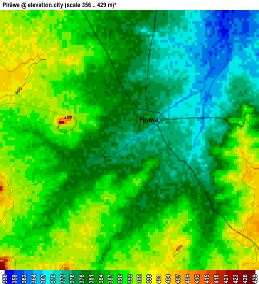
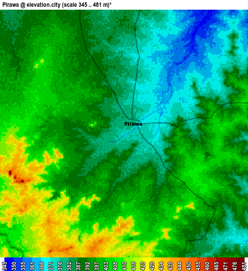
Below is the Elevation map of Pirāwa, which displays elevation range with different colors. Scale of the first map is from 356 to 429 m (1168 to 1407 ft) with average elevation of 385.1 meters (=1263 ft) [note 1]
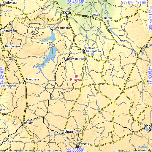
These maps also provides idea of topography and contour of this city, they are displayed at different zoom levels. More info about maps, scale and edge coordinates you can find below images.
| \ | Map #1 | Map #2 | Topo.Map |
| Scale [m] | 356..429 m | 345..481 m | × |
| Scale [ft] | 1168..1407 ft | 1132..1578 ft | × |
| Average | 385.1 m = 1263 ft | 393.6 m = 1291 ft | × |
| Width | 8.92 km = 5.5 mi | 17.83 km = 11.1 mi | 285.3 km = 177.3 mi |
| Height | 8.92 km = 5.5 mi | 17.83 km = 11.1 mi | 285.3 km = 177.3 mi |
| ↑Max Latitude | 24.195151° | 24.23523° | 25.43165° |
| Latitude at center | 24.15506° | 24.15506° | 24.15506° |
| ↓Min Latitude | 24.114956° | 24.07484° | 22.86558° |
| ← Min Longitude | 75.983335° | 75.939389° | 74.62103° |
| Longitude center | 76.02728° | 76.02728° | 76.02728° |
| →Max Longitude | 76.071225° | 76.115171° | 77.43353° |
Nearby cities:
Cities around Pirāwa sort by population:
• Jhālāwār elevation 322 m
51 km,  15°
15°
• Bhawāniganj 381 m
34.9 km,  326°
326°
• Rāmganj Mandi 362 m
55.3 km,  351°
351°
• Agar 519 m
49.3 km,  181°
181°
• Jhālrapātan 318 m
45.5 km, 18°
• Shāmgarh 469 m
39.6 km,  275°
275°
• Suket 329 m
54.6 km,  1°
1°
• Bhānpura 399 m
48.9 km,  324°
324°
• Sunel 357 m
25 km,  343°
343°
• Susner 417 m
24 km,  165°
165°
• Bakāni 350 m
25.8 km,  55°
55°
• Māchalpur 407 m
29.5 km,  95°
95°
Multilingual:
 En español:
Pirāwa elevación 372 m.
 En France:
Pirāwa élévation 372 m.


Sources and notes:
- [note 1] Map square and city borders are not equal. Map elevation data is calculated only from area inside that square.
- [src 1] Elevation data from geonames database provided with same terms of usage.
- [src 2] The elevation map of Pirāwa is generated using elevation data from NASA's 3 arcsec (90m) resolution SRTM data.
- [src 3] Base (background) map © OpenStreetMap contributors tiles are generated by Geofabrik and OpenTopoMap.
Copyright & License:
This Pirāwa Elevation Map is licensed under CC BY-SA. You may reuse any part from this page, if you give a proper credit by linking to this URL:
 More info on terms of use page.