Jhālrapātan elevation
Jhālrapātan (Rajasthan, Jhālāwār), India elevation is 318 meters and Jhālrapātan elevation in feet is 1043 ft above sea level [src 1]. Jhālrapātan is a populated place (feature code) with elevation that is 25 meters (82 ft) bigger than average city elevation in India.
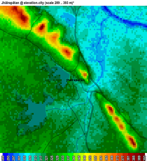
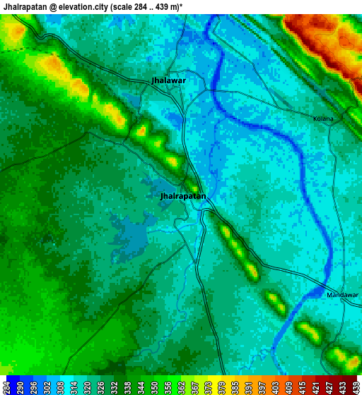
Below is the Elevation map of Jhālrapātan, which displays elevation range with different colors. Scale of the first map is from 289 to 393 m (948 to 1289 ft) with average elevation of 321.1 meters (=1053 ft) [note 1]
These maps also provides idea of topography and contour of this city, they are displayed at different zoom levels. More info about maps, scale and edge coordinates you can find below images.
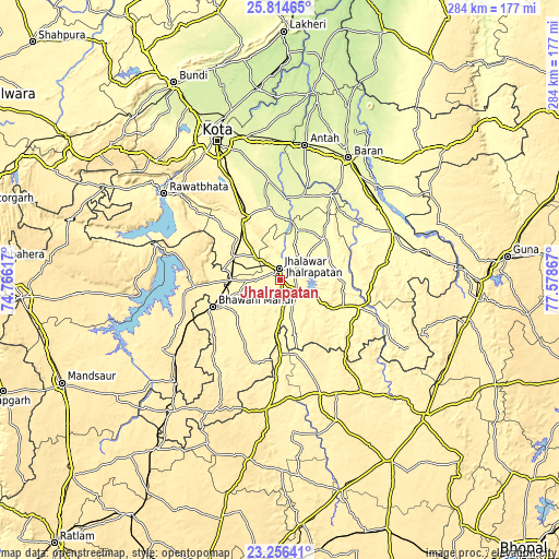
| \ | Map #1 | Map #2 | Topo.Map |
| Scale [m] | 289..393 m | 284..439 m | × |
| Scale [ft] | 948..1289 ft | 932..1440 ft | × |
| Average | 321.1 m = 1053 ft | 327.7 m = 1075 ft | × |
| Width | 8.89 km = 5.5 mi | 17.78 km = 11 mi | 284.4 km = 176.7 mi |
| Height | 8.89 km = 5.5 mi | 17.78 km = 11 mi | 284.5 km = 176.8 mi |
| ↑Max Latitude | 24.582019° | 24.621975° | 25.81465° |
| Latitude at center | 24.54205° | 24.54205° | 24.54205° |
| ↓Min Latitude | 24.502068° | 24.462074° | 23.25641° |
| ← Min Longitude | 76.128475° | 76.084529° | 74.76617° |
| Longitude center | 76.17242° | 76.17242° | 76.17242° |
| →Max Longitude | 76.216365° | 76.260311° | 77.57867° |
Nearby cities:
Cities around Jhālrapātan sort by population:
• Jhālāwār elevation 322 m
6.1 km,  352°
352°
• Bhawāniganj 381 m
36.9 km,  247°
247°
• Rāmganj Mandi 362 m
25.9 km,  296°
296°
• Suket 329 m
17.6 km,  311°
311°
• Sangod 266 m
44.3 km,  15°
15°
• Aklera 321 m
42.5 km,  109°
109°
• Bhānpura 399 m
43.2 km,  265°
265°
• Sunel 357 m
29 km,  228°
228°
• Khānpur 290 m
31 km,  46°
46°
• Chechat 333 m
38.4 km, 310°
• Udpura 338 m
29.2 km,  316°
316°
• Bakāni 350 m
29.2 km,  167°
167°
Multilingual:
 En español:
Jhālrapātan elevación 318 m.
 En France:
Jhālrapātan élévation 318 m.
 Auf Deutsch:
Jhālrapātan höhe über dem Meeresspiegel ist 318 m.

Sources and notes:
- [note 1] Map square and city borders are not equal. Map elevation data is calculated only from area inside that square.
- [src 1] Elevation data from geonames database provided with same terms of usage.
- [src 2] The elevation map of Jhālrapātan is generated using elevation data from NASA's 3 arcsec (90m) resolution SRTM data.
- [src 3] Base (background) map © OpenStreetMap contributors tiles are generated by Geofabrik and OpenTopoMap.
Copyright & License:
This Jhālrapātan Elevation Map is licensed under CC BY-SA. You may reuse any part from this page, if you give a proper credit by linking to this URL:
 More info on terms of use page.