Rāwatbhāta elevation
Rāwatbhāta (Rajasthan, Chittaurgarh), India elevation is 367 meters and Rāwatbhāta elevation in feet is 1204 ft above sea level [src 1]. Rāwatbhāta is a populated place (feature code) with elevation that is 74 meters (243 ft) bigger than average city elevation in India.
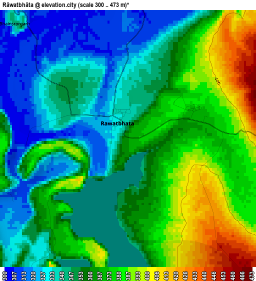
Below is the Elevation map of Rāwatbhāta, which displays elevation range with different colors. Scale of the first map is from 300 to 473 m (984 to 1552 ft) with average elevation of 358.4 meters (=1176 ft) [note 1]
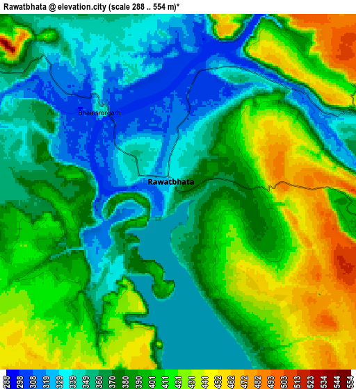
These maps also provides idea of topography and contour of this city, they are displayed at different zoom levels. More info about maps, scale and edge coordinates you can find below images.
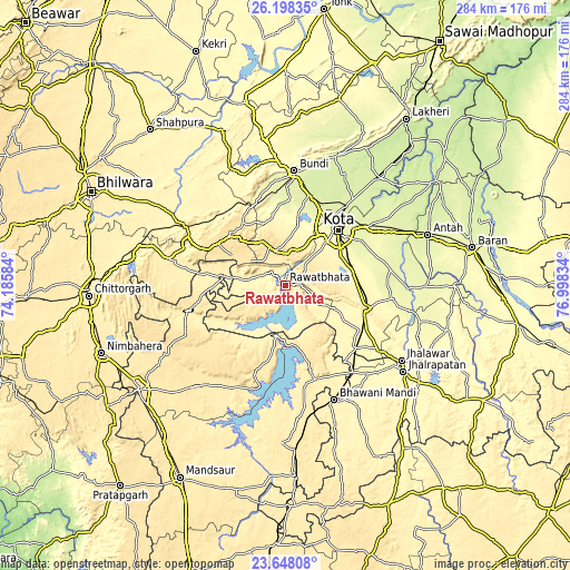
| \ | Map #1 | Map #2 | Topo.Map |
| Scale [m] | 300..473 m | 288..554 m | × |
| Scale [ft] | 984..1552 ft | 945..1818 ft | × |
| Average | 358.4 m = 1176 ft | 383.4 m = 1258 ft | × |
| Width | 8.86 km = 5.5 mi | 17.72 km = 11 mi | 283.6 km = 176.2 mi |
| Height | 8.86 km = 5.5 mi | 17.72 km = 11 mi | 283.6 km = 176.2 mi |
| ↑Max Latitude | 24.969654° | 25.009486° | 26.19835° |
| Latitude at center | 24.92981° | 24.92981° | 24.92981° |
| ↓Min Latitude | 24.889953° | 24.850083° | 23.64808° |
| ← Min Longitude | 75.548145° | 75.504199° | 74.18584° |
| Longitude center | 75.59209° | 75.59209° | 75.59209° |
| →Max Longitude | 75.636035° | 75.679981° | 76.99834° |
Nearby cities:
Cities around Rāwatbhāta sort by population:
• Kota elevation 267 m
37.5 km,  41°
41°
• Būndi 274 m
56.7 km,  4°
4°
• Rāmganj Mandi 362 m
47.4 km,  131°
131°
• Keshorai Pātan 254 m
53.4 km, 40°
• Begūn 420 m
60 km,  275°
275°
• Suket 329 m
55.3 km,  124°
124°
• Rāmpura 411 m
53.7 km,  196°
196°
• Bhānpura 399 m
48.9 km,  161°
161°
• Chechat 333 m
34.5 km, 121°
• Udpura 338 m
44.4 km, 119°
• Singoli 370 m
29.7 km, 277°
• Ratangarh 441 m
49.6 km,  255°
255°
Multilingual:
 En español:
Rāwatbhāta elevación 367 m.
 En France:
Rāwatbhāta élévation 367 m.
 Auf Deutsch:
Rāwatbhāta höhe über dem Meeresspiegel ist 367 m.

Sources and notes:
- [note 1] Map square and city borders are not equal. Map elevation data is calculated only from area inside that square.
- [src 1] Elevation data from geonames database provided with same terms of usage.
- [src 2] The elevation map of Rāwatbhāta is generated using elevation data from NASA's 3 arcsec (90m) resolution SRTM data.
- [src 3] Base (background) map © OpenStreetMap contributors tiles are generated by Geofabrik and OpenTopoMap.
Copyright & License:
This Rāwatbhāta Elevation Map is licensed under CC BY-SA. You may reuse any part from this page, if you give a proper credit by linking to this URL:
 More info on terms of use page.