Singoli elevation
Singoli (Madhya Pradesh, Neemuch), India elevation is 370 meters and Singoli elevation in feet is 1214 ft above sea level [src 1]. Singoli is a populated place (feature code) with elevation that is 77 meters (253 ft) bigger than average city elevation in India.
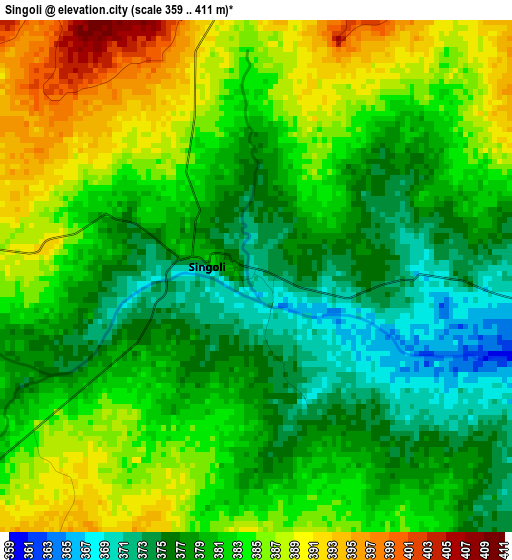
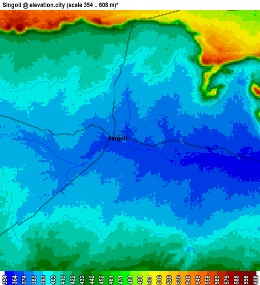
Below is the Elevation map of Singoli, which displays elevation range with different colors. Scale of the first map is from 359 to 411 m (1178 to 1348 ft) with average elevation of 381.2 meters (=1251 ft) [note 1]
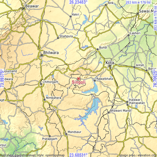
These maps also provides idea of topography and contour of this city, they are displayed at different zoom levels. More info about maps, scale and edge coordinates you can find below images.
| \ | Map #1 | Map #2 | Topo.Map |
| Scale [m] | 359..411 m | 354..608 m | × |
| Scale [ft] | 1178..1348 ft | 1161..1995 ft | × |
| Average | 381.2 m = 1251 ft | 407.4 m = 1337 ft | × |
| Width | 8.86 km = 5.5 mi | 17.72 km = 11 mi | 283.5 km = 176.2 mi |
| Height | 8.86 km = 5.5 mi | 17.72 km = 11 mi | 283.5 km = 176.2 mi |
| ↑Max Latitude | 25.006502° | 25.046322° | 26.23483° |
| Latitude at center | 24.96667° | 24.96667° | 24.96667° |
| ↓Min Latitude | 24.926825° | 24.886967° | 23.68531° |
| ← Min Longitude | 75.256055° | 75.212109° | 73.89375° |
| Longitude center | 75.3° | 75.3° | 75.3° |
| →Max Longitude | 75.343945° | 75.387891° | 76.70625° |
Nearby cities:
Cities around Singoli sort by population:
• Kota elevation 267 m
59.4 km,  66°
66°
• Chittaurgarh 405 m
68.7 km,  262°
262°
• Būndi 274 m
62.5 km,  32°
32°
• Rāwatbhāta 367 m
29.7 km,  97°
97°
• Manāsa 447 m
56.7 km,  196°
196°
• Māndalgarh 380 m
34.1 km,  317°
317°
• Begūn 420 m
30.3 km,  273°
273°
• Rāmpura 411 m
57.3 km,  165°
165°
• Bhānpura 399 m
67.7 km,  138°
138°
• Jāwad 467 m
60.2 km,  227°
227°
• Chechat 333 m
62.9 km,  110°
110°
• Ratangarh 441 m
24.9 km, 227°
Multilingual:
 En español:
Singoli elevación 370 m.
 En France:
Singoli élévation 370 m.


Sources and notes:
- [note 1] Map square and city borders are not equal. Map elevation data is calculated only from area inside that square.
- [src 1] Elevation data from geonames database provided with same terms of usage.
- [src 2] The elevation map of Singoli is generated using elevation data from NASA's 3 arcsec (90m) resolution SRTM data.
- [src 3] Base (background) map © OpenStreetMap contributors tiles are generated by Geofabrik and OpenTopoMap.
Copyright & License:
This Singoli Elevation Map is licensed under CC BY-SA. You may reuse any part from this page, if you give a proper credit by linking to this URL:
 More info on terms of use page.