Bissāu elevation
Bissāu (Rajasthan, Jhunjhunūn), India elevation is 299 meters and Bissāu elevation in feet is 981 ft above sea level [src 1]. Bissāu is a populated place (feature code) with elevation that is 6 meters (20 ft) bigger than average city elevation in India.
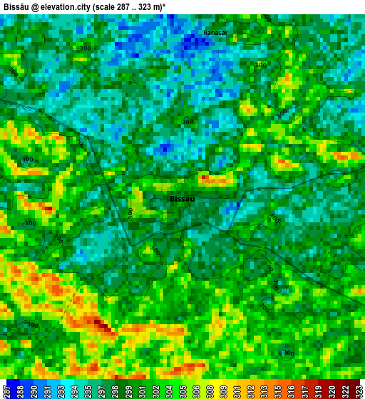
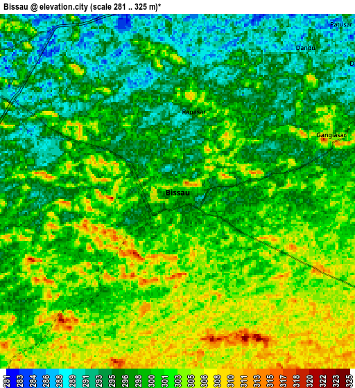
Below is the Elevation map of Bissāu, which displays elevation range with different colors. Scale of the first map is from 287 to 323 m (942 to 1060 ft) with average elevation of 299.9 meters (=984 ft) [note 1]
These maps also provides idea of topography and contour of this city, they are displayed at different zoom levels. More info about maps, scale and edge coordinates you can find below images.
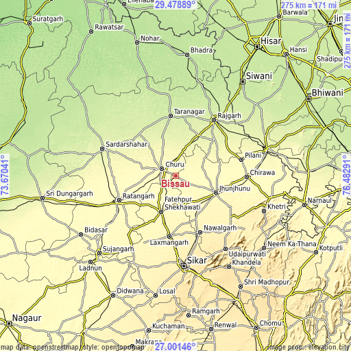
| \ | Map #1 | Map #2 | Topo.Map |
| Scale [m] | 287..323 m | 281..325 m | × |
| Scale [ft] | 942..1060 ft | 922..1066 ft | × |
| Average | 299.9 m = 984 ft | 299.3 m = 982 ft | × |
| Width | 8.61 km = 5.3 mi | 17.22 km = 10.7 mi | 275.5 km = 171.2 mi |
| Height | 8.61 km = 5.3 mi | 17.22 km = 10.7 mi | 275.5 km = 171.2 mi |
| ↑Max Latitude | 28.286075° | 28.324766° | 29.47889° |
| Latitude at center | 28.24737° | 28.24737° | 28.24737° |
| ↓Min Latitude | 28.208651° | 28.169918° | 27.00146° |
| ← Min Longitude | 75.032715° | 74.988769° | 73.67041° |
| Longitude center | 75.07666° | 75.07666° | 75.07666° |
| →Max Longitude | 75.120605° | 75.164551° | 76.48291° |
Nearby cities:
Cities around Bissāu sort by population:
• Jhunjhunūn elevation 343 m
34.3 km,  113°
113°
• Chūru 291 m
12.4 km,  300°
300°
• Fatehpur 329 m
30.5 km,  202°
202°
• Ratangarh 312 m
48.6 km,  247°
247°
• Nawalgarh 391 m
48.1 km,  156°
156°
• Rājgarh 240 m
53.3 km,  34°
34°
• Lachhmangarh Sīkar 365 m
47.4 km,  185°
185°
• Chidawa 316 m
55.2 km,  90°
90°
• Tārānagar 232 m
47 km,  354°
354°
• Pilāni 296 m
53.3 km,  75°
75°
• Bagar 328 m
42 km,  99°
99°
• Bhuma 354 m
53.5 km, 195°
Multilingual:
 En español:
Bissāu elevación 299 m.
 En France:
Bissāu élévation 299 m.


Sources and notes:
- [note 1] Map square and city borders are not equal. Map elevation data is calculated only from area inside that square.
- [src 1] Elevation data from geonames database provided with same terms of usage.
- [src 2] The elevation map of Bissāu is generated using elevation data from NASA's 3 arcsec (90m) resolution SRTM data.
- [src 3] Base (background) map © OpenStreetMap contributors tiles are generated by Geofabrik and OpenTopoMap.
Copyright & License:
This Bissāu Elevation Map is licensed under CC BY-SA. You may reuse any part from this page, if you give a proper credit by linking to this URL:
 More info on terms of use page.