Rājgarh elevation
Rājgarh (Rajasthan, Chūru), India elevation is 240 meters and Rājgarh elevation in feet is 787 ft above sea level [src 1]. Rājgarh is a populated place (feature code) with elevation that is 53 meters (174 ft) smaller than average city elevation in India.
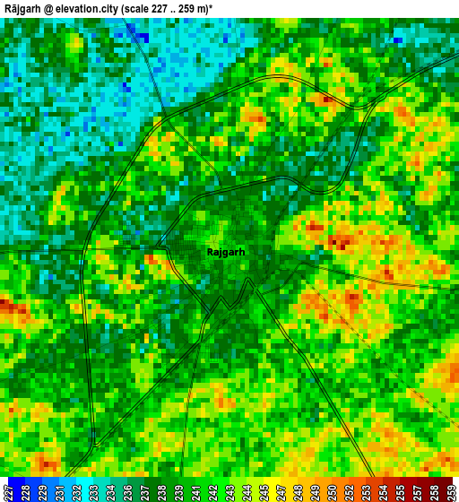
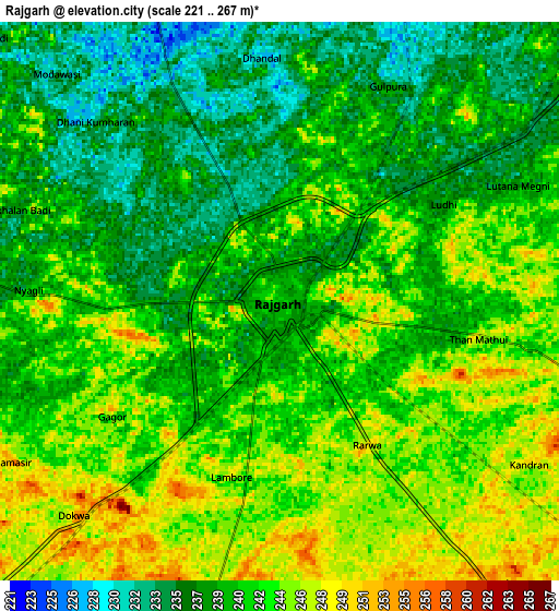
Below is the Elevation map of Rājgarh, which displays elevation range with different colors. Scale of the first map is from 227 to 259 m (745 to 850 ft) with average elevation of 240.2 meters (=788 ft) [note 1]
These maps also provides idea of topography and contour of this city, they are displayed at different zoom levels. More info about maps, scale and edge coordinates you can find below images.
| \ | Map #1 | Map #2 | Topo.Map |
| Scale [m] | 227..259 m | 221..267 m | × |
| Scale [ft] | 745..850 ft | 725..876 ft | × |
| Average | 240.2 m = 788 ft | 240.9 m = 790 ft | × |
| Width | 8.58 km = 5.3 mi | 17.15 km = 10.7 mi | 274.4 km = 170.5 mi |
| Height | 8.58 km = 5.3 mi | 17.15 km = 10.7 mi | 274.4 km = 170.5 mi |
| ↑Max Latitude | 28.680571° | 28.719117° | 29.86885° |
| Latitude at center | 28.64201° | 28.64201° | 28.64201° |
| ↓Min Latitude | 28.603435° | 28.564846° | 27.40065° |
| ← Min Longitude | 75.342175° | 75.298229° | 73.97987° |
| Longitude center | 75.38612° | 75.38612° | 75.38612° |
| →Max Longitude | 75.430065° | 75.474011° | 76.79237° |
Nearby cities:
Cities around Rājgarh sort by population:
• Jhunjhunūn elevation 343 m
57.4 km,  178°
178°
• Chūru 291 m
55.6 km,  227°
227°
• Chidawa 316 m
51.2 km,  150°
150°
• Bhādra 200 m
55.4 km,  337°
337°
• Tārānagar 232 m
34.7 km,  274°
274°
• Pilāni 296 m
37.2 km, 145°
• Bissāu 299 m
53.3 km,  214°
214°
• Sūrajgarh 298 m
50.1 km,  137°
137°
• Bagar 328 m
51.7 km,  167°
167°
• Toshām 213 m
57.6 km,  63°
63°
• Lohāru 275 m
47.5 km,  119°
119°
• Mandholi Kalān 234 m
29.9 km,  75°
75°
Multilingual:
 En español:
Rājgarh elevación 240 m.
 En France:
Rājgarh élévation 240 m.


Sources and notes:
- [note 1] Map square and city borders are not equal. Map elevation data is calculated only from area inside that square.
- [src 1] Elevation data from geonames database provided with same terms of usage.
- [src 2] The elevation map of Rājgarh is generated using elevation data from NASA's 3 arcsec (90m) resolution SRTM data.
- [src 3] Base (background) map © OpenStreetMap contributors tiles are generated by Geofabrik and OpenTopoMap.
Copyright & License:
This Rājgarh Elevation Map is licensed under CC BY-SA. You may reuse any part from this page, if you give a proper credit by linking to this URL:
 More info on terms of use page.