Toshām elevation
Toshām (Haryana, Bhiwani), India elevation is 213 meters and Toshām elevation in feet is 699 ft above sea level [src 1]. Toshām is a populated place (feature code) with elevation that is 80 meters (262 ft) smaller than average city elevation in India.
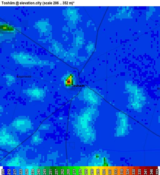
Below is the Elevation map of Toshām, which displays elevation range with different colors. Scale of the first map is from 206 to 352 m (676 to 1155 ft) with average elevation of 216.2 meters (=709 ft) [note 1]
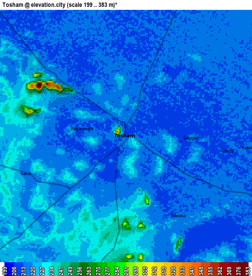
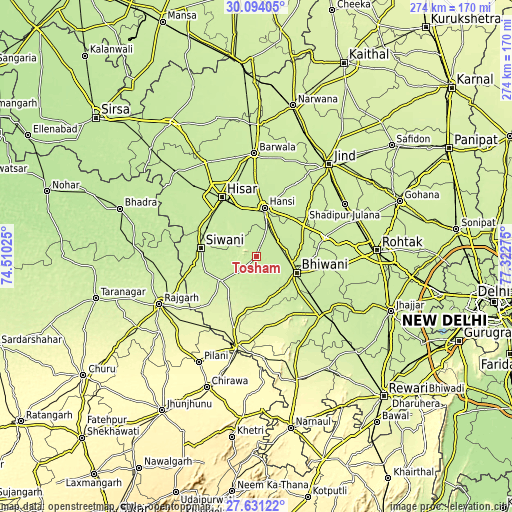
These maps also provides idea of topography and contour of this city, they are displayed at different zoom levels. More info about maps, scale and edge coordinates you can find below images.
| \ | Map #1 | Map #2 | Topo.Map |
| Scale [m] | 206..352 m | 199..383 m | × |
| Scale [ft] | 676..1155 ft | 653..1257 ft | × |
| Average | 216.2 m = 709 ft | 218.8 m = 718 ft | × |
| Width | 8.56 km = 5.3 mi | 17.12 km = 10.6 mi | 273.8 km = 170.1 mi |
| Height | 8.56 km = 5.3 mi | 17.12 km = 10.6 mi | 273.8 km = 170.1 mi |
| ↑Max Latitude | 28.908407° | 28.946869° | 30.09405° |
| Latitude at center | 28.86993° | 28.86993° | 28.86993° |
| ↓Min Latitude | 28.831439° | 28.792934° | 27.63122° |
| ← Min Longitude | 75.872555° | 75.828609° | 74.51025° |
| Longitude center | 75.9165° | 75.9165° | 75.9165° |
| →Max Longitude | 75.960445° | 76.004391° | 77.32275° |
Nearby cities:
Cities around Toshām sort by population:
• Hisar elevation 216 m
36.8 km,  329°
329°
• Bhiwāni 223 m
23.4 km,  111°
111°
• Hānsi 225 m
26.2 km,  9°
9°
• Charkhi Dādri 225 m
46.4 km,  131°
131°
• Rājgarh 240 m
57.6 km,  243°
243°
• Barwāla 226 m
55.3 km,  359°
359°
• Maham 226 m
38.4 km,  73°
73°
• Kalānaur 227 m
46.9 km,  95°
95°
• Nārnaund 230 m
44.8 km,  29°
29°
• Shādīpur Julāna 227 m
55.3 km,  59°
59°
• Lohāru 275 m
50.1 km,  192°
192°
• Mandholi Kalān 234 m
29 km,  231°
231°
Multilingual:
 En español:
Toshām elevación 213 m.
 En France:
Toshām élévation 213 m.


Sources and notes:
- [note 1] Map square and city borders are not equal. Map elevation data is calculated only from area inside that square.
- [src 1] Elevation data from geonames database provided with same terms of usage.
- [src 2] The elevation map of Toshām is generated using elevation data from NASA's 3 arcsec (90m) resolution SRTM data.
- [src 3] Base (background) map © OpenStreetMap contributors tiles are generated by Geofabrik and OpenTopoMap.
Copyright & License:
This Toshām Elevation Map is licensed under CC BY-SA. You may reuse any part from this page, if you give a proper credit by linking to this URL:
 More info on terms of use page.