Dhūlia elevation
Dhūlia (Maharashtra, Dhule), India elevation is 266 meters and Dhūlia elevation in feet is 873 ft above sea level [src 1]. Dhūlia is a seat of a second-order administrative division (feature code) with elevation that is 27 meters (89 ft) smaller than average city elevation in India.
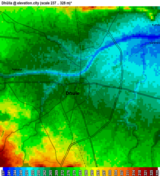
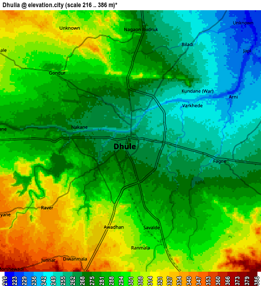
Below is the Elevation map of Dhūlia, which displays elevation range with different colors. Scale of the first map is from 237 to 328 m (778 to 1076 ft) with average elevation of 270.1 meters (=886 ft) [note 1]
These maps also provides idea of topography and contour of this city, they are displayed at different zoom levels. More info about maps, scale and edge coordinates you can find below images.
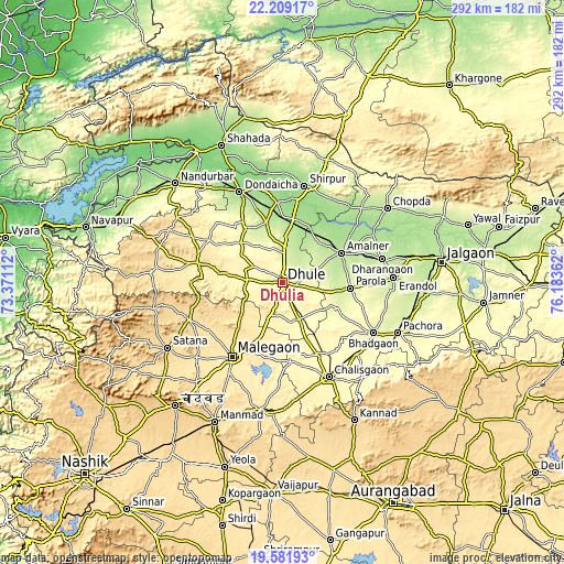
| \ | Map #1 | Map #2 | Topo.Map |
| Scale [m] | 237..328 m | 216..386 m | × |
| Scale [ft] | 778..1076 ft | 709..1266 ft | × |
| Average | 270.1 m = 886 ft | 285.6 m = 937 ft | × |
| Width | 9.13 km = 5.7 mi | 18.26 km = 11.3 mi | 292.1 km = 181.5 mi |
| Height | 9.13 km = 5.7 mi | 18.26 km = 11.3 mi | 292.1 km = 181.5 mi |
| ↑Max Latitude | 20.942348° | 20.983385° | 22.20917° |
| Latitude at center | 20.9013° | 20.9013° | 20.9013° |
| ↓Min Latitude | 20.860241° | 20.81917° | 19.58193° |
| ← Min Longitude | 74.733425° | 74.689479° | 73.37112° |
| Longitude center | 74.77737° | 74.77737° | 74.77737° |
| →Max Longitude | 74.821315° | 74.865261° | 76.18362° |
Nearby cities:
Cities around Dhūlia sort by population:
• Mālegaon elevation 432 m
46.5 km,  212°
212°
• Amalner 189 m
33 km,  62°
62°
• Chālisgaon 346 m
55.2 km,  153°
153°
• Shirpur 157 m
50.8 km,  12°
12°
• Chopda 195 m
66.3 km,  54°
54°
• Pāchora 262 m
65.3 km,  113°
113°
• Dondaicha 163 m
51.7 km,  335°
335°
• Parola 256 m
35.6 km,  93°
93°
• Satānā 557 m
68.8 km,  240°
240°
• Dharangaon 218 m
53 km,  76°
76°
• Erandol 226 m
57.1 km, 87°
• Nāndgaon 480 m
67.3 km,  190°
190°
Multilingual:
 En español:
Dhūlia elevación 266 m.
 En France:
Dhūlia élévation 266 m.


Sources and notes:
- [note 1] Map square and city borders are not equal. Map elevation data is calculated only from area inside that square.
- [src 1] Elevation data from geonames database provided with same terms of usage.
- [src 2] The elevation map of Dhūlia is generated using elevation data from NASA's 3 arcsec (90m) resolution SRTM data.
- [src 3] Base (background) map © OpenStreetMap contributors tiles are generated by Geofabrik and OpenTopoMap.
Copyright & License:
This Dhūlia Elevation Map is licensed under CC BY-SA. You may reuse any part from this page, if you give a proper credit by linking to this URL:
 More info on terms of use page.