Dondaicha elevation
Dondaicha (Maharashtra, Dhule), India elevation is 163 meters and Dondaicha elevation in feet is 535 ft above sea level [src 1]. Dondaicha is a populated place (feature code) with elevation that is 130 meters (427 ft) smaller than average city elevation in India.
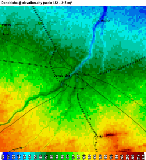
Below is the Elevation map of Dondaicha, which displays elevation range with different colors. Scale of the first map is from 132 to 215 m (433 to 705 ft) with average elevation of 166.3 meters (=546 ft) [note 1]
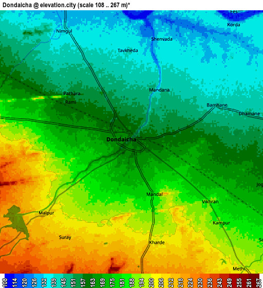
These maps also provides idea of topography and contour of this city, they are displayed at different zoom levels. More info about maps, scale and edge coordinates you can find below images.
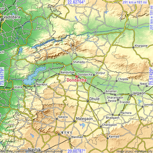
| \ | Map #1 | Map #2 | Topo.Map |
| Scale [m] | 132..215 m | 108..267 m | × |
| Scale [ft] | 433..705 ft | 354..876 ft | × |
| Average | 166.3 m = 546 ft | 171.1 m = 561 ft | × |
| Width | 9.1 km = 5.7 mi | 18.21 km = 11.3 mi | 291.3 km = 181 mi |
| Height | 9.1 km = 5.7 mi | 18.21 km = 11.3 mi | 291.3 km = 181 mi |
| ↑Max Latitude | 21.364531° | 21.405451° | 22.62764° |
| Latitude at center | 21.3236° | 21.3236° | 21.3236° |
| ↓Min Latitude | 21.282657° | 21.241703° | 20.00787° |
| ← Min Longitude | 74.524095° | 74.480149° | 73.16179° |
| Longitude center | 74.56804° | 74.56804° | 74.56804° |
| →Max Longitude | 74.611985° | 74.655931° | 75.97429° |
Nearby cities:
Cities around Dondaicha sort by population:
• Dhūlia elevation 266 m
51.7 km,  155°
155°
• Nandurbar 216 m
34.3 km,  278°
278°
• Amalner 189 m
59.9 km,  121°
121°
• Shirpur 157 m
32.5 km,  85°
85°
• Chopda 195 m
76.3 km,  96°
96°
• Shāhāda 140 m
26.6 km,  337°
337°
• Sendhwa 410 m
67.9 km,  53°
53°
• Parola 256 m
75.5 km,  130°
130°
• Dharangaon 218 m
81 km, 115°
• Taloda 126 m
45.3 km,  305°
305°
• Khetia 214 m
38.7 km,  2°
2°
• Pānsemāl 243 m
39.8 km,  19°
19°
Multilingual:
 En español:
Dondaicha elevación 163 m.
 En France:
Dondaicha élévation 163 m.
 Auf Deutsch:
Dondaicha höhe über dem Meeresspiegel ist 163 m.

Sources and notes:
- [note 1] Map square and city borders are not equal. Map elevation data is calculated only from area inside that square.
- [src 1] Elevation data from geonames database provided with same terms of usage.
- [src 2] The elevation map of Dondaicha is generated using elevation data from NASA's 3 arcsec (90m) resolution SRTM data.
- [src 3] Base (background) map © OpenStreetMap contributors tiles are generated by Geofabrik and OpenTopoMap.
Copyright & License:
This Dondaicha Elevation Map is licensed under CC BY-SA. You may reuse any part from this page, if you give a proper credit by linking to this URL:
 More info on terms of use page.