Pāchora elevation
Pāchora (Maharashtra, Jalgaon), India elevation is 262 meters and Pāchora elevation in feet is 860 ft above sea level [src 1]. Pāchora is a populated place (feature code) with elevation that is 31 meters (102 ft) smaller than average city elevation in India.
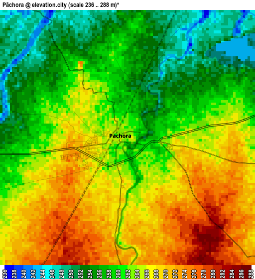
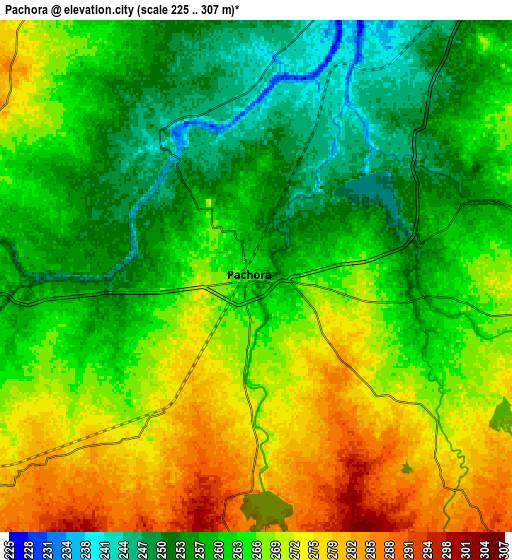
Below is the Elevation map of Pāchora, which displays elevation range with different colors. Scale of the first map is from 236 to 288 m (774 to 945 ft) with average elevation of 262.3 meters (=861 ft) [note 1]
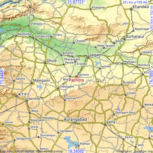
These maps also provides idea of topography and contour of this city, they are displayed at different zoom levels. More info about maps, scale and edge coordinates you can find below images.
| \ | Map #1 | Map #2 | Topo.Map |
| Scale [m] | 236..288 m | 225..307 m | × |
| Scale [ft] | 774..945 ft | 738..1007 ft | × |
| Average | 262.3 m = 861 ft | 264.3 m = 867 ft | × |
| Width | 9.14 km = 5.7 mi | 18.29 km = 11.4 mi | 292.6 km = 181.8 mi |
| Height | 9.14 km = 5.7 mi | 18.29 km = 11.4 mi | 292.6 km = 181.8 mi |
| ↑Max Latitude | 20.708382° | 20.749482° | 21.97723° |
| Latitude at center | 20.66727° | 20.66727° | 20.66727° |
| ↓Min Latitude | 20.626147° | 20.585013° | 19.34592° |
| ← Min Longitude | 75.309105° | 75.265159° | 73.9468° |
| Longitude center | 75.35305° | 75.35305° | 75.35305° |
| →Max Longitude | 75.396995° | 75.440941° | 76.7593° |
Nearby cities:
Cities around Pāchora sort by population:
• Jalgaon elevation 227 m
43.4 km,  30°
30°
• Dhūlia 266 m
65.3 km,  293°
293°
• Bhusāval 206 m
61.4 km,  47°
47°
• Amalner 189 m
51.5 km,  323°
323°
• Chālisgaon 346 m
42.1 km,  236°
236°
• Chopda 195 m
64.6 km,  355°
355°
• Sillod 616 m
51.1 km,  142°
142°
• Kannad 629 m
50.8 km,  206°
206°
• Parola 256 m
34 km,  314°
314°
• Dharangaon 218 m
39.2 km,  347°
347°
• Erandol 226 m
28.5 km, 354°
• Soygaon 377 m
28.6 km,  106°
106°
Multilingual:
 En español:
Pāchora elevación 262 m.
 En France:
Pāchora élévation 262 m.


Sources and notes:
- [note 1] Map square and city borders are not equal. Map elevation data is calculated only from area inside that square.
- [src 1] Elevation data from geonames database provided with same terms of usage.
- [src 2] The elevation map of Pāchora is generated using elevation data from NASA's 3 arcsec (90m) resolution SRTM data.
- [src 3] Base (background) map © OpenStreetMap contributors tiles are generated by Geofabrik and OpenTopoMap.
Copyright & License:
This Pāchora Elevation Map is licensed under CC BY-SA. You may reuse any part from this page, if you give a proper credit by linking to this URL:
 More info on terms of use page.