Isāgarh elevation
Isāgarh (Madhya Pradesh, Ashoknagar), India elevation is 491 meters and Isāgarh elevation in feet is 1611 ft above sea level [src 1]. Isāgarh is a populated place (feature code) with elevation that is 198 meters (650 ft) bigger than average city elevation in India.
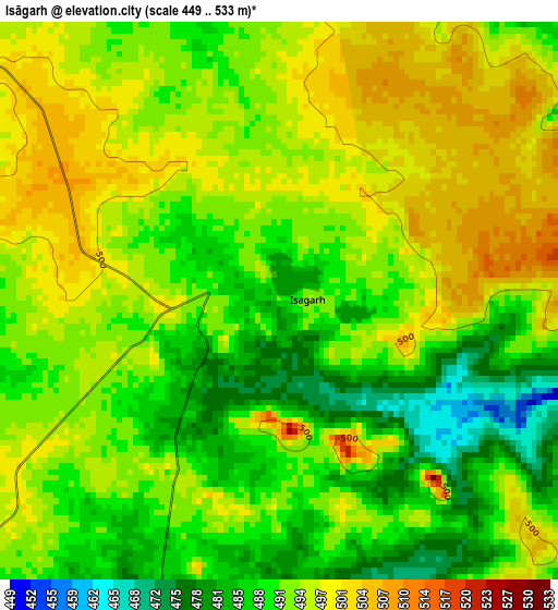
Below is the Elevation map of Isāgarh, which displays elevation range with different colors. Scale of the first map is from 449 to 533 m (1473 to 1749 ft) with average elevation of 492.6 meters (=1616 ft) [note 1]
These maps also provides idea of topography and contour of this city, they are displayed at different zoom levels. More info about maps, scale and edge coordinates you can find below images.
| \ | Map #1 | Map #2 | Topo.Map |
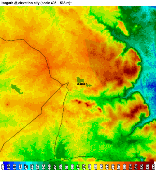
| Scale [m] | 449..533 m | 408..533 m | × |
| Scale [ft] | 1473..1749 ft | 1339..1749 ft | × |
| Average | 492.6 m = 1616 ft | 480.2 m = 1575 ft | × |
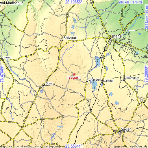
| Width | 8.87 km = 5.5 mi | 17.74 km = 11 mi | 283.8 km = 176.3 mi |
| Height | 8.87 km = 5.5 mi | 17.74 km = 11 mi | 283.8 km = 176.3 mi |
| ↑Max Latitude | 24.878934° | 24.918794° | 26.10856° |
| Latitude at center | 24.83906° | 24.83906° | 24.83906° |
| ↓Min Latitude | 24.799174° | 24.759274° | 23.55641° |
| ← Min Longitude | 77.838795° | 77.794849° | 76.47649° |
| Longitude center | 77.88274° | 77.88274° | 77.88274° |
| →Max Longitude | 77.926685° | 77.970631° | 79.28899° |
Nearby cities:
Cities around Isāgarh sort by population:
• Shivpuri elevation 463 m
68.7 km,  341°
341°
• Guna 474 m
61.5 km,  249°
249°
• Lalitpur 360 m
56.6 km,  107°
107°
• Ashoknagar 504 m
33 km,  207°
207°
• Chanderi 453 m
29.3 km,  118°
118°
• Bāmor Kalān 355 m
27.7 km,  77°
77°
• Mungaoli 410 m
52.5 km,  155°
155°
• Kolāras 454 m
50.3 km,  327°
327°
• Tālbahat 307 m
60.1 km,  67°
67°
• Badarwās 460 m
35.4 km,  295°
295°
• Pāli 393 m
66.3 km,  125°
125°
• Bijrauni 462 m
26.3 km,  293°
293°
Multilingual:
 En español:
Isāgarh elevación 491 m.
 En France:
Isāgarh élévation 491 m.


Sources and notes:
- [note 1] Map square and city borders are not equal. Map elevation data is calculated only from area inside that square.
- [src 1] Elevation data from geonames database provided with same terms of usage.
- [src 2] The elevation map of Isāgarh is generated using elevation data from NASA's 3 arcsec (90m) resolution SRTM data.
- [src 3] Base (background) map © OpenStreetMap contributors tiles are generated by Geofabrik and OpenTopoMap.
Copyright & License:
This Isāgarh Elevation Map is licensed under CC BY-SA. You may reuse any part from this page, if you give a proper credit by linking to this URL:
 More info on terms of use page.