Lalitpur elevation
Lalitpur (Uttar Pradesh), India elevation is 360 meters and Lalitpur elevation in feet is 1181 ft above sea level [src 1]. Lalitpur is a populated place (feature code) with elevation that is 67 meters (220 ft) bigger than average city elevation in India.
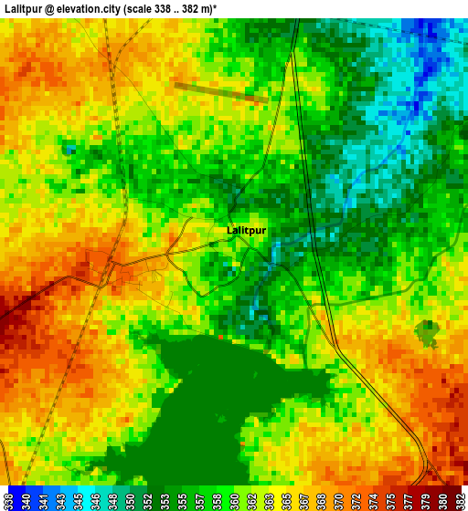
Below is the Elevation map of Lalitpur, which displays elevation range with different colors. Scale of the first map is from 338 to 382 m (1109 to 1253 ft) with average elevation of 360.8 meters (=1184 ft) [note 1]
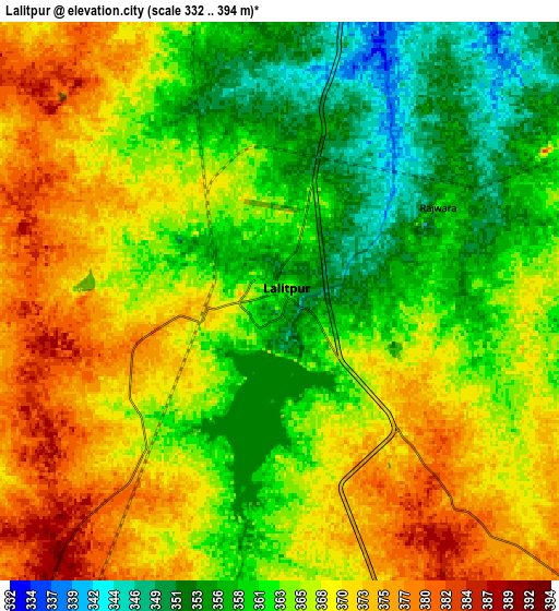
These maps also provides idea of topography and contour of this city, they are displayed at different zoom levels. More info about maps, scale and edge coordinates you can find below images.
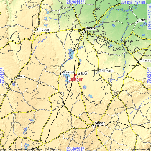
| \ | Map #1 | Map #2 | Topo.Map |
| Scale [m] | 338..382 m | 332..394 m | × |
| Scale [ft] | 1109..1253 ft | 1089..1293 ft | × |
| Average | 360.8 m = 1184 ft | 365.1 m = 1198 ft | × |
| Width | 8.88 km = 5.5 mi | 17.76 km = 11 mi | 284.1 km = 176.5 mi |
| Height | 8.88 km = 5.5 mi | 17.76 km = 11 mi | 284.1 km = 176.5 mi |
| ↑Max Latitude | 24.729991° | 24.7699° | 25.96113° |
| Latitude at center | 24.69007° | 24.69007° | 24.69007° |
| ↓Min Latitude | 24.650136° | 24.610189° | 23.40591° |
| ← Min Longitude | 78.375205° | 78.331259° | 77.0129° |
| Longitude center | 78.41915° | 78.41915° | 78.41915° |
| →Max Longitude | 78.463095° | 78.507041° | 79.8254° |
Nearby cities:
Cities around Lalitpur sort by population:
• Tīkamgarh elevation 360 m
42 km,  81°
81°
• Ashoknagar 504 m
70.7 km,  259°
259°
• Etāwa 414 m
60.4 km,  201°
201°
• Babīna 287 m
61.3 km,  4°
4°
• Chanderi 453 m
28.5 km,  275°
275°
• Bāmor Kalān 355 m
35.2 km,  309°
309°
• Mungaoli 410 m
45.3 km,  226°
226°
• Tālbahat 307 m
39.3 km, 2°
• Isāgarh 491 m
56.6 km,  287°
287°
• Pāli 393 m
22 km,  180°
180°
• Mahroni 374 m
33.3 km,  110°
110°
• Baldeogarh 341 m
65.9 km, 83°
Multilingual:
 En español:
Lalitpur elevación 360 m.
 En France:
Lalitpur élévation 360 m.
 Auf Deutsch:
Lalitpur höhe über dem Meeresspiegel ist 360 m.

Sources and notes:
- [note 1] Map square and city borders are not equal. Map elevation data is calculated only from area inside that square.
- [src 1] Elevation data from geonames database provided with same terms of usage.
- [src 2] The elevation map of Lalitpur is generated using elevation data from NASA's 3 arcsec (90m) resolution SRTM data.
- [src 3] Base (background) map © OpenStreetMap contributors tiles are generated by Geofabrik and OpenTopoMap.
Copyright & License:
This Lalitpur Elevation Map is licensed under CC BY-SA. You may reuse any part from this page, if you give a proper credit by linking to this URL:
 More info on terms of use page.