Tālbahat elevation
Tālbahat (Uttar Pradesh, Lalitpur), India elevation is 307 meters and Tālbahat elevation in feet is 1007 ft above sea level [src 1]. Tālbahat is a populated place (feature code) with elevation that is 14 meters (46 ft) bigger than average city elevation in India.
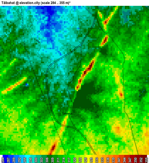
Below is the Elevation map of Tālbahat, which displays elevation range with different colors. Scale of the first map is from 284 to 355 m (932 to 1165 ft) with average elevation of 311.3 meters (=1021 ft) [note 1]
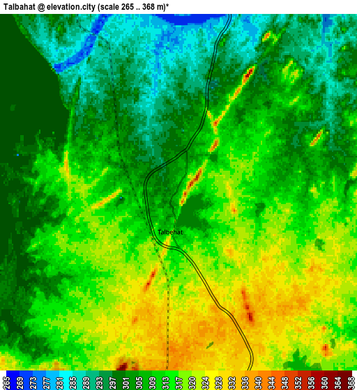
These maps also provides idea of topography and contour of this city, they are displayed at different zoom levels. More info about maps, scale and edge coordinates you can find below images.
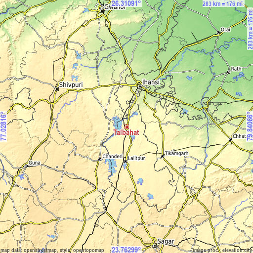
| \ | Map #1 | Map #2 | Topo.Map |
| Scale [m] | 284..355 m | 265..368 m | × |
| Scale [ft] | 932..1165 ft | 869..1207 ft | × |
| Average | 311.3 m = 1021 ft | 308.8 m = 1013 ft | × |
| Width | 8.85 km = 5.5 mi | 17.71 km = 11 mi | 283.3 km = 176 mi |
| Height | 8.85 km = 5.5 mi | 17.71 km = 11 mi | 283.3 km = 176 mi |
| ↑Max Latitude | 25.083377° | 25.123172° | 26.31091° |
| Latitude at center | 25.04357° | 25.04357° | 25.04357° |
| ↓Min Latitude | 25.00375° | 24.963916° | 23.76299° |
| ← Min Longitude | 78.390465° | 78.346519° | 77.02816° |
| Longitude center | 78.43441° | 78.43441° | 78.43441° |
| →Max Longitude | 78.478355° | 78.522301° | 79.84066° |
Nearby cities:
Cities around Tālbahat sort by population:
• Jhānsi elevation 248 m
48.4 km,  17°
17°
• Lalitpur 360 m
39.3 km,  182°
182°
• Tīkamgarh 360 m
52.1 km,  129°
129°
• Babīna 287 m
22.1 km,  9°
9°
• Chanderi 453 m
47.4 km,  219°
219°
• Bāmor Kalān 355 m
33.1 km,  239°
239°
• Karera 279 m
55 km,  326°
326°
• Khailār 271 m
34.5 km, 16°
• Isāgarh 491 m
60.1 km,  247°
247°
• Mahroni 374 m
58.8 km,  149°
149°
• Barāgaon 206 m
55.6 km,  30°
30°
• Orchha 218 m
40.1 km, 31°
Multilingual:
 En español:
Tālbahat elevación 307 m.
 En France:
Tālbahat élévation 307 m.
 Auf Deutsch:
Tālbahat höhe über dem Meeresspiegel ist 307 m.

Sources and notes:
- [note 1] Map square and city borders are not equal. Map elevation data is calculated only from area inside that square.
- [src 1] Elevation data from geonames database provided with same terms of usage.
- [src 2] The elevation map of Tālbahat is generated using elevation data from NASA's 3 arcsec (90m) resolution SRTM data.
- [src 3] Base (background) map © OpenStreetMap contributors tiles are generated by Geofabrik and OpenTopoMap.
Copyright & License:
This Tālbahat Elevation Map is licensed under CC BY-SA. You may reuse any part from this page, if you give a proper credit by linking to this URL:
 More info on terms of use page.