Khailār elevation
Khailār (Madhya Pradesh), India elevation is 271 meters and Khailār elevation in feet is 889 ft above sea level [src 1]. Khailār is a populated place (feature code) with elevation that is 22 meters (72 ft) smaller than average city elevation in India.
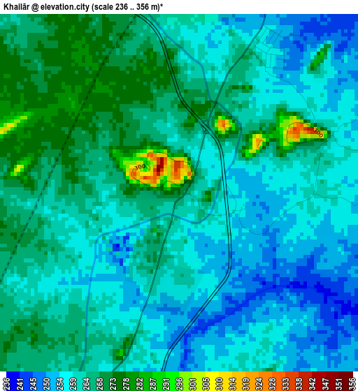
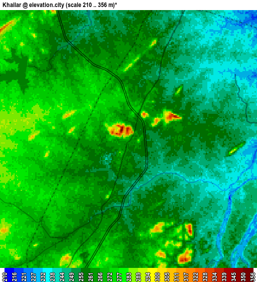
Below is the Elevation map of Khailār, which displays elevation range with different colors. Scale of the first map is from 236 to 356 m (774 to 1168 ft) with average elevation of 262.5 meters (=861 ft) [note 1]
These maps also provides idea of topography and contour of this city, they are displayed at different zoom levels. More info about maps, scale and edge coordinates you can find below images.
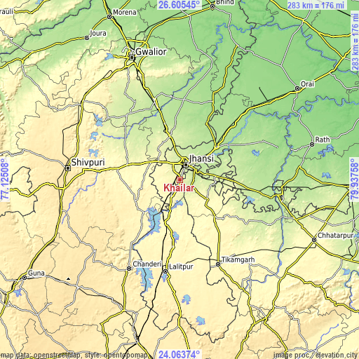
| \ | Map #1 | Map #2 | Topo.Map |
| Scale [m] | 236..356 m | 210..356 m | × |
| Scale [ft] | 774..1168 ft | 689..1168 ft | × |
| Average | 262.5 m = 861 ft | 260.3 m = 854 ft | × |
| Width | 8.83 km = 5.5 mi | 17.66 km = 11 mi | 282.6 km = 175.6 mi |
| Height | 8.83 km = 5.5 mi | 17.66 km = 11 mi | 282.6 km = 175.6 mi |
| ↑Max Latitude | 25.38098° | 25.420677° | 26.60545° |
| Latitude at center | 25.34127° | 25.34127° | 25.34127° |
| ↓Min Latitude | 25.301547° | 25.261811° | 24.06374° |
| ← Min Longitude | 78.487385° | 78.443439° | 77.12508° |
| Longitude center | 78.53133° | 78.53133° | 78.53133° |
| →Max Longitude | 78.575275° | 78.619221° | 79.93758° |
Nearby cities:
Cities around Khailār sort by population:
• Jhānsi elevation 248 m
14 km,  20°
20°
• Datia 247 m
37.6 km,  348°
348°
• Babīna 287 m
12.9 km,  208°
208°
• Karera 279 m
41.8 km,  288°
288°
• Bhānder 182 m
48.9 km,  26°
26°
• Rānīpur 222 m
54.3 km,  100°
100°
• Chirgaon 199 m
38.3 km,  47°
47°
• Tālbahat 307 m
34.5 km,  196°
196°
• Tori-Fatehpur 182 m
59.9 km,  77°
77°
• Barāgaon 206 m
23.5 km, 50°
• Orchha 218 m
11 km, 83°
• Pārīchha 207 m
29.5 km, 51°
Multilingual:
 En español:
Khailār elevación 271 m.
 En France:
Khailār élévation 271 m.


Sources and notes:
- [note 1] Map square and city borders are not equal. Map elevation data is calculated only from area inside that square.
- [src 1] Elevation data from geonames database provided with same terms of usage.
- [src 2] The elevation map of Khailār is generated using elevation data from NASA's 3 arcsec (90m) resolution SRTM data.
- [src 3] Base (background) map © OpenStreetMap contributors tiles are generated by Geofabrik and OpenTopoMap.
Copyright & License:
This Khailār Elevation Map is licensed under CC BY-SA. You may reuse any part from this page, if you give a proper credit by linking to this URL:
 More info on terms of use page.