Rānīpur elevation
Rānīpur (Uttar Pradesh, Jhānsi), India elevation is 222 meters and Rānīpur elevation in feet is 728 ft above sea level [src 1]. Rānīpur is a populated place (feature code) with elevation that is 71 meters (233 ft) smaller than average city elevation in India.
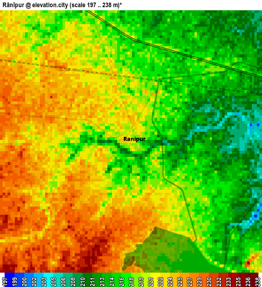
Below is the Elevation map of Rānīpur, which displays elevation range with different colors. Scale of the first map is from 197 to 238 m (646 to 781 ft) with average elevation of 219.6 meters (=720 ft) [note 1]
These maps also provides idea of topography and contour of this city, they are displayed at different zoom levels. More info about maps, scale and edge coordinates you can find below images.
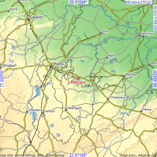
| \ | Map #1 | Map #2 | Topo.Map |
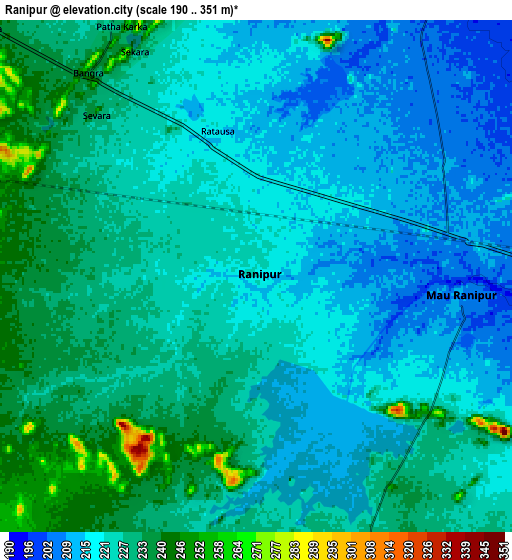
| Scale [m] | 197..238 m | 190..351 m | × |
| Scale [ft] | 646..781 ft | 623..1152 ft | × |
| Average | 219.6 m = 720 ft | 224 m = 735 ft | × |
| Width | 8.84 km = 5.5 mi | 17.68 km = 11 mi | 282.8 km = 175.7 mi |
| Height | 8.84 km = 5.5 mi | 17.68 km = 11 mi | 282.8 km = 175.7 mi |
| ↑Max Latitude | 25.29008° | 25.329807° | 26.51549° |
| Latitude at center | 25.25034° | 25.25034° | 25.25034° |
| ↓Min Latitude | 25.210587° | 25.170821° | 23.97188° |
| ← Min Longitude | 79.018095° | 78.974149° | 77.65579° |
| Longitude center | 79.06204° | 79.06204° | 79.06204° |
| →Max Longitude | 79.105985° | 79.149931° | 80.46829° |
Nearby cities:
Cities around Rānīpur sort by population:
• Jhānsi elevation 248 m
53.7 km,  295°
295°
• Gursarāi 183 m
42.4 km,  16°
16°
• Harpālpur 214 m
27.5 km,  81°
81°
• Jatāra 262 m
26.8 km,  182°
182°
• Palera 237 m
30.6 km,  146°
146°
• Chirgaon 199 m
43.6 km,  325°
325°
• Khargāpur 304 m
48.2 km,  170°
170°
• Tori-Fatehpur 182 m
23.4 km,  12°
12°
• Garautha 155 m
42.9 km,  33°
33°
• Barāgaon 206 m
43.2 km,  305°
305°
• Orchha 218 m
43.9 km,  284°
284°
• Pārīchha 207 m
41.8 km, 313°
Multilingual:
 En español:
Rānīpur elevación 222 m.
 En France:
Rānīpur élévation 222 m.


Sources and notes:
- [note 1] Map square and city borders are not equal. Map elevation data is calculated only from area inside that square.
- [src 1] Elevation data from geonames database provided with same terms of usage.
- [src 2] The elevation map of Rānīpur is generated using elevation data from NASA's 3 arcsec (90m) resolution SRTM data.
- [src 3] Base (background) map © OpenStreetMap contributors tiles are generated by Geofabrik and OpenTopoMap.
Copyright & License:
This Rānīpur Elevation Map is licensed under CC BY-SA. You may reuse any part from this page, if you give a proper credit by linking to this URL:
 More info on terms of use page.