Garautha elevation
Garautha (Uttar Pradesh, Jhānsi), India elevation is 155 meters and Garautha elevation in feet is 509 ft above sea level [src 1]. Garautha is a populated place (feature code) with elevation that is 138 meters (453 ft) smaller than average city elevation in India.
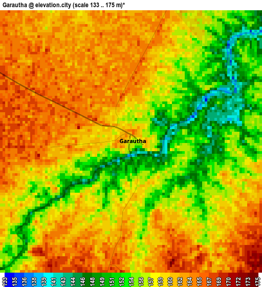
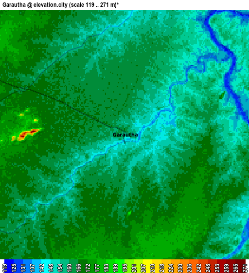
Below is the Elevation map of Garautha, which displays elevation range with different colors. Scale of the first map is from 133 to 175 m (436 to 574 ft) with average elevation of 158.6 meters (=520 ft) [note 1]
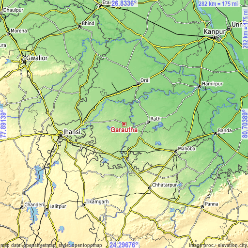
These maps also provides idea of topography and contour of this city, they are displayed at different zoom levels. More info about maps, scale and edge coordinates you can find below images.
| \ | Map #1 | Map #2 | Topo.Map |
| Scale [m] | 133..175 m | 119..271 m | × |
| Scale [ft] | 436..574 ft | 390..889 ft | × |
| Average | 158.6 m = 520 ft | 161.7 m = 531 ft | × |
| Width | 8.82 km = 5.5 mi | 17.63 km = 11 mi | 282.1 km = 175.3 mi |
| Height | 8.82 km = 5.5 mi | 17.63 km = 11 mi | 282.1 km = 175.3 mi |
| ↑Max Latitude | 25.611534° | 25.651155° | 26.8336° |
| Latitude at center | 25.5719° | 25.5719° | 25.5719° |
| ↓Min Latitude | 25.532253° | 25.492593° | 24.29676° |
| ← Min Longitude | 79.253695° | 79.209749° | 77.89139° |
| Longitude center | 79.29764° | 79.29764° | 79.29764° |
| →Max Longitude | 79.341585° | 79.385531° | 80.70389° |
Nearby cities:
Cities around Garautha sort by population:
• Rāth elevation 171 m
27.1 km,  84°
84°
• Gursarāi 183 m
12.8 km,  293°
293°
• Charkhāri 198 m
49 km,  112°
112°
• Kulpahār 198 m
44.3 km,  129°
129°
• Rānīpur 222 m
42.9 km,  213°
213°
• Harpālpur 214 m
31.8 km,  173°
173°
• Chirgaon 199 m
48.5 km,  270°
270°
• Moth 179 m
38.8 km,  296°
296°
• Tori-Fatehpur 182 m
22.5 km,  234°
234°
• Kotra 155 m
26.2 km,  2°
2°
• Sarīla 148 m
44.1 km,  59°
59°
• Gohānd 153 m
28.6 km, 60°
Multilingual:
 En español:
Garautha elevación 155 m.
 En France:
Garautha élévation 155 m.
 Auf Deutsch:
Garautha höhe über dem Meeresspiegel ist 155 m.

Sources and notes:
- [note 1] Map square and city borders are not equal. Map elevation data is calculated only from area inside that square.
- [src 1] Elevation data from geonames database provided with same terms of usage.
- [src 2] The elevation map of Garautha is generated using elevation data from NASA's 3 arcsec (90m) resolution SRTM data.
- [src 3] Base (background) map © OpenStreetMap contributors tiles are generated by Geofabrik and OpenTopoMap.
Copyright & License:
This Garautha Elevation Map is licensed under CC BY-SA. You may reuse any part from this page, if you give a proper credit by linking to this URL:
 More info on terms of use page.