Shivpuri elevation
Shivpuri (Madhya Pradesh, Shivpurī), India elevation is 463 meters and Shivpuri elevation in feet is 1519 ft above sea level [src 1]. Shivpuri is a populated place (feature code) with elevation that is 170 meters (558 ft) bigger than average city elevation in India.
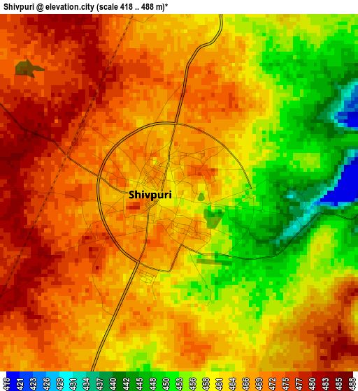
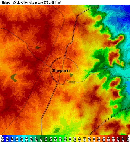
Below is the Elevation map of Shivpuri, which displays elevation range with different colors. Scale of the first map is from 418 to 488 m (1371 to 1601 ft) with average elevation of 464.6 meters (=1524 ft) [note 1]
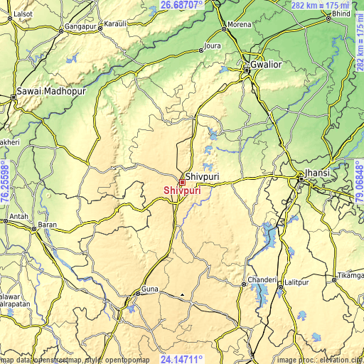
These maps also provides idea of topography and contour of this city, they are displayed at different zoom levels. More info about maps, scale and edge coordinates you can find below images.
| \ | Map #1 | Map #2 | Topo.Map |
| Scale [m] | 418..488 m | 376..491 m | × |
| Scale [ft] | 1371..1601 ft | 1234..1611 ft | × |
| Average | 464.6 m = 1524 ft | 456.2 m = 1497 ft | × |
| Width | 8.83 km = 5.5 mi | 17.65 km = 11 mi | 282.4 km = 175.5 mi |
| Height | 8.83 km = 5.5 mi | 17.65 km = 11 mi | 282.4 km = 175.5 mi |
| ↑Max Latitude | 25.463463° | 25.503133° | 26.68707° |
| Latitude at center | 25.42378° | 25.42378° | 25.42378° |
| ↓Min Latitude | 25.384084° | 25.344375° | 24.14711° |
| ← Min Longitude | 77.618285° | 77.574339° | 76.25598° |
| Longitude center | 77.66223° | 77.66223° | 77.66223° |
| →Max Longitude | 77.706175° | 77.750121° | 79.06848° |
Nearby cities:
Cities around Shivpuri sort by population:
• Datia elevation 247 m
84.6 km,  70°
70°
• Dabra 207 m
84.5 km,  52°
52°
• Babīna 287 m
83.8 km,  104°
104°
• Bāmor Kalān 355 m
76.8 km,  140°
140°
• Karera 279 m
47.7 km,  85°
85°
• Bhitarwār 238 m
60.8 km, 47°
• Kolāras 454 m
23.3 km,  192°
192°
• Narwar 286 m
35.1 km, 45°
• Khailār 271 m
87.8 km, 95°
• Badarwās 460 m
50.8 km, 191°
• Isāgarh 491 m
68.7 km,  161°
161°
• Bijrauni 462 m
54.6 km,  181°
181°
Multilingual:
 En español:
Shivpuri elevación 463 m.
 En France:
Shivpuri élévation 463 m.
 Auf Deutsch:
Shivpuri höhe über dem Meeresspiegel ist 463 m.

Sources and notes:
- [note 1] Map square and city borders are not equal. Map elevation data is calculated only from area inside that square.
- [src 1] Elevation data from geonames database provided with same terms of usage.
- [src 2] The elevation map of Shivpuri is generated using elevation data from NASA's 3 arcsec (90m) resolution SRTM data.
- [src 3] Base (background) map © OpenStreetMap contributors tiles are generated by Geofabrik and OpenTopoMap.
Copyright & License:
This Shivpuri Elevation Map is licensed under CC BY-SA. You may reuse any part from this page, if you give a proper credit by linking to this URL:
 More info on terms of use page.