Jaithāri elevation
Jaithāri (Madhya Pradesh, Raisen), India elevation is 394 meters and Jaithāri elevation in feet is 1293 ft above sea level [src 1]. Jaithāri is a populated place (feature code) with elevation that is 101 meters (331 ft) bigger than average city elevation in India.
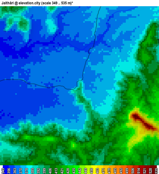
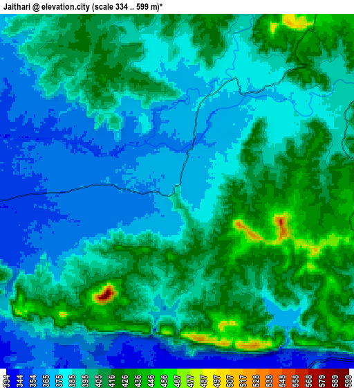
Below is the Elevation map of Jaithāri, which displays elevation range with different colors. Scale of the first map is from 349 to 535 m (1145 to 1755 ft) with average elevation of 386.2 meters (=1267 ft) [note 1]
These maps also provides idea of topography and contour of this city, they are displayed at different zoom levels. More info about maps, scale and edge coordinates you can find below images.
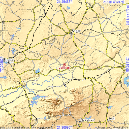
| \ | Map #1 | Map #2 | Topo.Map |
| Scale [m] | 349..535 m | 334..599 m | × |
| Scale [ft] | 1145..1755 ft | 1096..1965 ft | × |
| Average | 386.2 m = 1267 ft | 392.4 m = 1287 ft | × |
| Width | 8.98 km = 5.6 mi | 17.96 km = 11.2 mi | 287.4 km = 178.6 mi |
| Height | 8.98 km = 5.6 mi | 17.96 km = 11.2 mi | 287.4 km = 178.6 mi |
| ↑Max Latitude | 23.248943° | 23.289314° | 24.49467° |
| Latitude at center | 23.20856° | 23.20856° | 23.20856° |
| ↓Min Latitude | 23.168165° | 23.127757° | 21.90995° |
| ← Min Longitude | 78.570925° | 78.526979° | 77.20862° |
| Longitude center | 78.61487° | 78.61487° | 78.61487° |
| →Max Longitude | 78.658815° | 78.702761° | 80.02112° |
Nearby cities:
Cities around Jaithāri sort by population:
• Narsimhapur elevation 357 m
64.9 km,  116°
116°
• Gādarwāra 339 m
36.2 km,  151°
151°
• Begamganj 513 m
51.7 km,  327°
327°
• Kareli 365 m
56.3 km,  125°
125°
• Rehli 406 m
66 km,  43°
43°
• Rāhatgarh 474 m
68.4 km,  340°
340°
• Deori Khās 429 m
45.7 km,  63°
63°
• Sohāgpur 333 m
71 km,  217°
217°
• Udaipura 325 m
18.3 km, 215°
• Dhāna 519 m
65 km,  22°
22°
• Chichli 346 m
47 km, 152°
• Sultānpur 368 m
70 km,  263°
263°
Multilingual:
 En español:
Jaithāri elevación 394 m.
 En France:
Jaithāri élévation 394 m.
 Auf Deutsch:
Jaithāri höhe über dem Meeresspiegel ist 394 m.

Sources and notes:
- [note 1] Map square and city borders are not equal. Map elevation data is calculated only from area inside that square.
- [src 1] Elevation data from geonames database provided with same terms of usage.
- [src 2] The elevation map of Jaithāri is generated using elevation data from NASA's 3 arcsec (90m) resolution SRTM data.
- [src 3] Base (background) map © OpenStreetMap contributors tiles are generated by Geofabrik and OpenTopoMap.
Copyright & License:
This Jaithāri Elevation Map is licensed under CC BY-SA. You may reuse any part from this page, if you give a proper credit by linking to this URL:
 More info on terms of use page.