Sohāgpur elevation
Sohāgpur (Madhya Pradesh, Hoshangābād), India elevation is 333 meters and Sohāgpur elevation in feet is 1093 ft above sea level [src 1]. Sohāgpur is a populated place (feature code) with elevation that is 40 meters (131 ft) bigger than average city elevation in India.
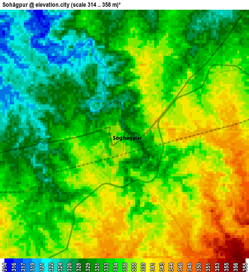
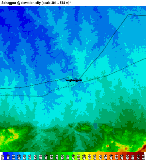
Below is the Elevation map of Sohāgpur, which displays elevation range with different colors. Scale of the first map is from 314 to 358 m (1030 to 1175 ft) with average elevation of 334 meters (=1096 ft) [note 1]
These maps also provides idea of topography and contour of this city, they are displayed at different zoom levels. More info about maps, scale and edge coordinates you can find below images.
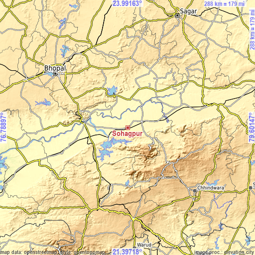
| \ | Map #1 | Map #2 | Topo.Map |
| Scale [m] | 314..358 m | 301..518 m | × |
| Scale [ft] | 1030..1175 ft | 988..1699 ft | × |
| Average | 334 m = 1096 ft | 340.7 m = 1118 ft | × |
| Width | 9.02 km = 5.6 mi | 18.03 km = 11.2 mi | 288.5 km = 179.3 mi |
| Height | 9.02 km = 5.6 mi | 18.03 km = 11.2 mi | 288.5 km = 179.3 mi |
| ↑Max Latitude | 22.741085° | 22.781608° | 23.99163° |
| Latitude at center | 22.70055° | 22.70055° | 22.70055° |
| ↓Min Latitude | 22.660003° | 22.619444° | 21.39718° |
| ← Min Longitude | 78.151275° | 78.107329° | 76.78897° |
| Longitude center | 78.19522° | 78.19522° | 78.19522° |
| →Max Longitude | 78.239165° | 78.283111° | 79.60147° |
Nearby cities:
Cities around Sohāgpur sort by population:
• Hoshangābād elevation 301 m
48.3 km,  276°
276°
• Itārsi 325 m
45.4 km,  257°
257°
• Gādarwāra 339 m
65.3 km,  67°
67°
• Jāmai 773 m
69.3 km,  143°
143°
• Bābai 322 m
26.7 km,  270°
270°
• Udaipura 325 m
52.7 km,  37°
37°
• Chichli 346 m
66.4 km,  77°
77°
• Sultānpur 368 m
55.5 km,  331°
331°
• Jaithāri 394 m
71 km, 37°
• Shāhpur 393 m
63.5 km,  207°
207°
• Panara 791 m
66.1 km,  146°
146°
• Pachmarhi 1061 m
35.6 km, 136°
Multilingual:
 En español:
Sohāgpur elevación 333 m.
 En France:
Sohāgpur élévation 333 m.
 Auf Deutsch:
Sohāgpur höhe über dem Meeresspiegel ist 333 m.

Sources and notes:
- [note 1] Map square and city borders are not equal. Map elevation data is calculated only from area inside that square.
- [src 1] Elevation data from geonames database provided with same terms of usage.
- [src 2] The elevation map of Sohāgpur is generated using elevation data from NASA's 3 arcsec (90m) resolution SRTM data.
- [src 3] Base (background) map © OpenStreetMap contributors tiles are generated by Geofabrik and OpenTopoMap.
Copyright & License:
This Sohāgpur Elevation Map is licensed under CC BY-SA. You may reuse any part from this page, if you give a proper credit by linking to this URL:
 More info on terms of use page.