Itārsi elevation
Itārsi (Madhya Pradesh, Hoshangābād), India elevation is 325 meters and Itārsi elevation in feet is 1066 ft above sea level [src 1]. Itārsi is a populated place (feature code) with elevation that is 32 meters (105 ft) bigger than average city elevation in India.
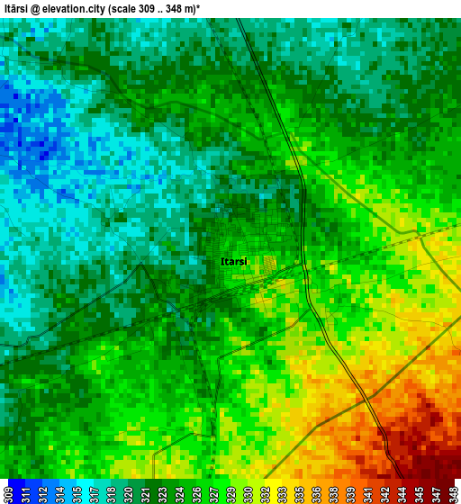
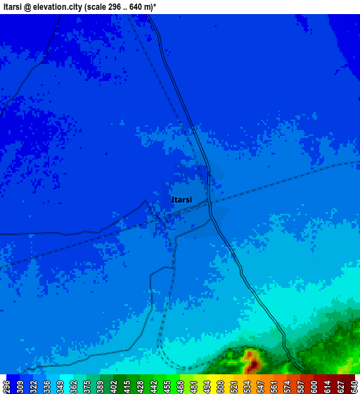
Below is the Elevation map of Itārsi, which displays elevation range with different colors. Scale of the first map is from 309 to 348 m (1014 to 1142 ft) with average elevation of 324.1 meters (=1063 ft) [note 1]
These maps also provides idea of topography and contour of this city, they are displayed at different zoom levels. More info about maps, scale and edge coordinates you can find below images.
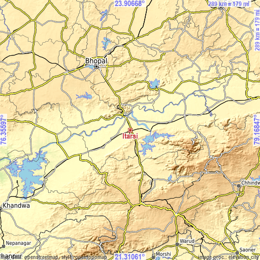
| \ | Map #1 | Map #2 | Topo.Map |
| Scale [m] | 309..348 m | 296..640 m | × |
| Scale [ft] | 1014..1142 ft | 971..2100 ft | × |
| Average | 324.1 m = 1063 ft | 329.1 m = 1080 ft | × |
| Width | 9.02 km = 5.6 mi | 18.04 km = 11.2 mi | 288.7 km = 179.4 mi |
| Height | 9.02 km = 5.6 mi | 18.04 km = 11.2 mi | 288.7 km = 179.4 mi |
| ↑Max Latitude | 22.65533° | 22.695879° | 23.90668° |
| Latitude at center | 22.61477° | 22.61477° | 22.61477° |
| ↓Min Latitude | 22.574198° | 22.533613° | 21.31061° |
| ← Min Longitude | 77.718275° | 77.674329° | 76.35597° |
| Longitude center | 77.76222° | 77.76222° | 77.76222° |
| →Max Longitude | 77.806165° | 77.850111° | 79.16847° |
Nearby cities:
Cities around Itārsi sort by population:
• Hoshangābād elevation 301 m
15.2 km,  346°
346°
• Harda Khās 294 m
74.8 km,  246°
246°
• Raisen 448 m
79.6 km,  1°
1°
• Mandideep 443 m
57 km,  335°
335°
• Seoni Mālwa 319 m
35.4 km,  238°
238°
• Sohāgpur 333 m
45.4 km,  77°
77°
• Nasrullāhganj 301 m
51 km,  278°
278°
• Bābai 322 m
20.2 km,  61°
61°
• Rehti 308 m
36.3 km,  292°
292°
• Sultānpur 368 m
60.8 km,  16°
16°
• Shāhpur 393 m
49 km,  162°
162°
• Pachmarhi 1061 m
70.8 km,  103°
103°
Multilingual:
 En español:
Itārsi elevación 325 m.
 En France:
Itārsi élévation 325 m.


Sources and notes:
- [note 1] Map square and city borders are not equal. Map elevation data is calculated only from area inside that square.
- [src 1] Elevation data from geonames database provided with same terms of usage.
- [src 2] The elevation map of Itārsi is generated using elevation data from NASA's 3 arcsec (90m) resolution SRTM data.
- [src 3] Base (background) map © OpenStreetMap contributors tiles are generated by Geofabrik and OpenTopoMap.
Copyright & License:
This Itārsi Elevation Map is licensed under CC BY-SA. You may reuse any part from this page, if you give a proper credit by linking to this URL:
 More info on terms of use page.