Panara elevation
Panara (Madhya Pradesh, Chhindwāra), India elevation is 791 meters and Panara elevation in feet is 2595 ft above sea level [src 1]. Panara is a populated place (feature code) with elevation that is 498 meters (1634 ft) bigger than average city elevation in India.
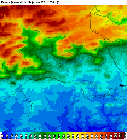
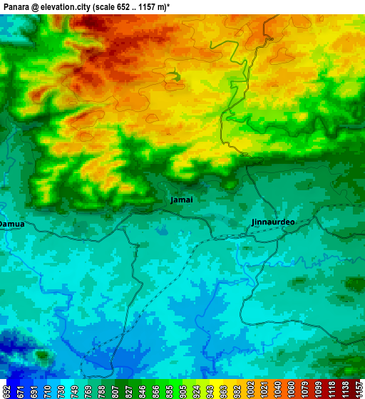
Below is the Elevation map of Panara, which displays elevation range with different colors. Scale of the first map is from 720 to 1032 m (2362 to 3386 ft) with average elevation of 834.8 meters (=2739 ft) [note 1]
These maps also provides idea of topography and contour of this city, they are displayed at different zoom levels. More info about maps, scale and edge coordinates you can find below images.
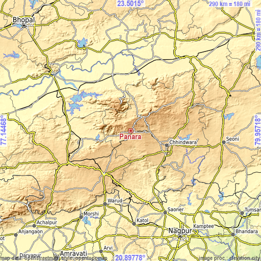
| \ | Map #1 | Map #2 | Topo.Map |
| Scale [m] | 720..1032 m | 652..1157 m | × |
| Scale [ft] | 2362..3386 ft | 2139..3796 ft | × |
| Average | 834.8 m = 2739 ft | 838.3 m = 2750 ft | × |
| Width | 9.05 km = 5.6 mi | 18.1 km = 11.2 mi | 289.5 km = 179.9 mi |
| Height | 9.05 km = 5.6 mi | 18.1 km = 11.2 mi | 289.5 km = 179.9 mi |
| ↑Max Latitude | 22.24636° | 22.287028° | 23.5015° |
| Latitude at center | 22.20568° | 22.20568° | 22.20568° |
| ↓Min Latitude | 22.164988° | 22.124284° | 20.89778° |
| ← Min Longitude | 78.506985° | 78.463039° | 77.14468° |
| Longitude center | 78.55093° | 78.55093° | 78.55093° |
| →Max Longitude | 78.594875° | 78.638821° | 79.95718° |
Nearby cities:
Cities around Panara sort by population:
• Chhindwāra elevation 688 m
43.3 km,  112°
112°
• Pāndhurnā 470 m
67.9 km,  182°
182°
• Parāsia 781 m
21.5 km,  94°
94°
• Amla 745 m
53.6 km,  234°
234°
• Sausar 360 m
66.2 km,  157°
157°
• Sohāgpur 333 m
66.1 km,  326°
326°
• Jāmai 773 m
4.3 km,  103°
103°
• Multai 758 m
56.7 km,  212°
212°
• Amarwāra 807 m
64.5 km,  80°
80°
• Mohgaon 371 m
65.8 km, 163°
• Shāhpur 393 m
66.3 km,  268°
268°
• Pachmarhi 1061 m
31.6 km,  337°
337°
Multilingual:
 En español:
Panara elevación 791 m.
 En France:
Panara élévation 791 m.


Sources and notes:
- [note 1] Map square and city borders are not equal. Map elevation data is calculated only from area inside that square.
- [src 1] Elevation data from geonames database provided with same terms of usage.
- [src 2] The elevation map of Panara is generated using elevation data from NASA's 3 arcsec (90m) resolution SRTM data.
- [src 3] Base (background) map © OpenStreetMap contributors tiles are generated by Geofabrik and OpenTopoMap.
Copyright & License:
This Panara Elevation Map is licensed under CC BY-SA. You may reuse any part from this page, if you give a proper credit by linking to this URL:
 More info on terms of use page.