Rāhatgarh elevation
Rāhatgarh (Madhya Pradesh, Sāgar), India elevation is 474 meters and Rāhatgarh elevation in feet is 1555 ft above sea level [src 1]. Rāhatgarh is a populated place (feature code) with elevation that is 181 meters (594 ft) bigger than average city elevation in India.
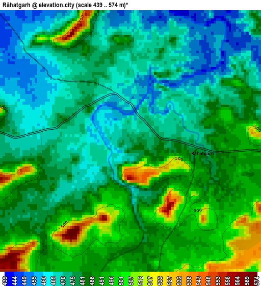
Below is the Elevation map of Rāhatgarh, which displays elevation range with different colors. Scale of the first map is from 439 to 574 m (1440 to 1883 ft) with average elevation of 480.5 meters (=1576 ft) [note 1]
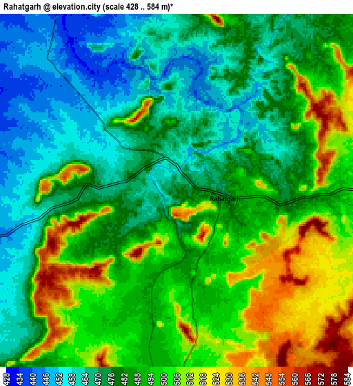
These maps also provides idea of topography and contour of this city, they are displayed at different zoom levels. More info about maps, scale and edge coordinates you can find below images.
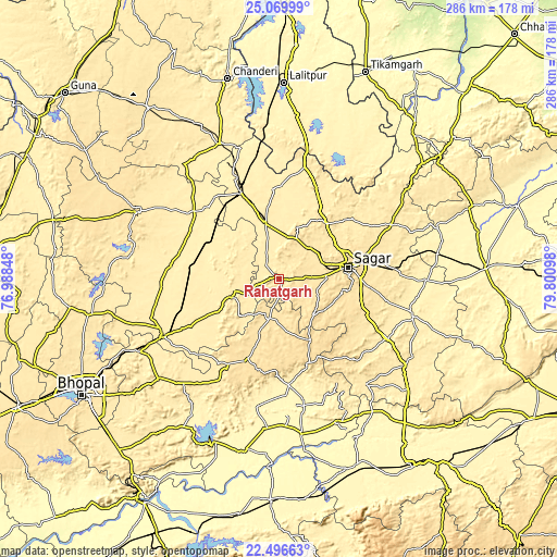
| \ | Map #1 | Map #2 | Topo.Map |
| Scale [m] | 439..574 m | 428..584 m | × |
| Scale [ft] | 1440..1883 ft | 1404..1916 ft | × |
| Average | 480.5 m = 1576 ft | 486.1 m = 1595 ft | × |
| Width | 8.94 km = 5.6 mi | 17.88 km = 11.1 mi | 286.1 km = 177.8 mi |
| Height | 8.94 km = 5.6 mi | 17.88 km = 11.1 mi | 286.1 km = 177.8 mi |
| ↑Max Latitude | 23.829885° | 23.870078° | 25.06999° |
| Latitude at center | 23.78968° | 23.78968° | 23.78968° |
| ↓Min Latitude | 23.749462° | 23.709232° | 22.49663° |
| ← Min Longitude | 78.350785° | 78.306839° | 76.98848° |
| Longitude center | 78.39473° | 78.39473° | 78.39473° |
| →Max Longitude | 78.438675° | 78.482621° | 79.80098° |
Nearby cities:
Cities around Rāhatgarh sort by population:
• Saugor elevation 520 m
35.4 km,  81°
81°
• Vidisha 429 m
66.3 km,  243°
243°
• Bāsoda 410 m
47.1 km,  278°
278°
• Etāwa 414 m
47.9 km,  336°
336°
• Begamganj 513 m
21.9 km,  194°
194°
• Khurai 439 m
29 km,  346°
346°
• Banda 475 m
64.2 km,  63°
63°
• Korwai 406 m
51.3 km,  315°
315°
• Shāhpur 418 m
67.7 km, 80°
• Dhāna 519 m
47.8 km,  95°
95°
• Karrāpur 502 m
51.1 km,  69°
69°
• Bamora 419 m
42.9 km,  313°
313°
Multilingual:
 En español:
Rāhatgarh elevación 474 m.
 En France:
Rāhatgarh élévation 474 m.
 Auf Deutsch:
Rāhatgarh höhe über dem Meeresspiegel ist 474 m.

Sources and notes:
- [note 1] Map square and city borders are not equal. Map elevation data is calculated only from area inside that square.
- [src 1] Elevation data from geonames database provided with same terms of usage.
- [src 2] The elevation map of Rāhatgarh is generated using elevation data from NASA's 3 arcsec (90m) resolution SRTM data.
- [src 3] Base (background) map © OpenStreetMap contributors tiles are generated by Geofabrik and OpenTopoMap.
Copyright & License:
This Rāhatgarh Elevation Map is licensed under CC BY-SA. You may reuse any part from this page, if you give a proper credit by linking to this URL:
 More info on terms of use page.