Kareli elevation
Kareli (Madhya Pradesh, Narsimhapur), India elevation is 365 meters and Kareli elevation in feet is 1198 ft above sea level [src 1]. Kareli is a populated place (feature code) with elevation that is 72 meters (236 ft) bigger than average city elevation in India.
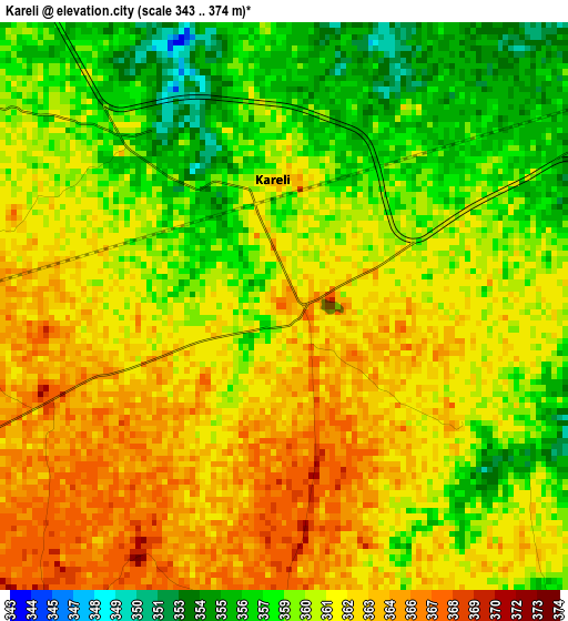
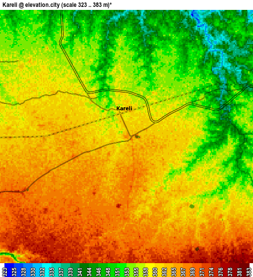
Below is the Elevation map of Kareli, which displays elevation range with different colors. Scale of the first map is from 343 to 374 m (1125 to 1227 ft) with average elevation of 360.6 meters (=1183 ft) [note 1]
These maps also provides idea of topography and contour of this city, they are displayed at different zoom levels. More info about maps, scale and edge coordinates you can find below images.
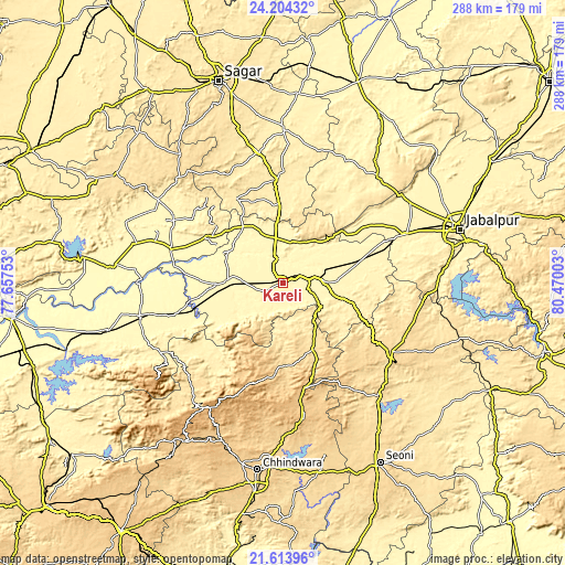
| \ | Map #1 | Map #2 | Topo.Map |
| Scale [m] | 343..374 m | 323..383 m | × |
| Scale [ft] | 1125..1227 ft | 1060..1257 ft | × |
| Average | 360.6 m = 1183 ft | 358.7 m = 1177 ft | × |
| Width | 9 km = 5.6 mi | 18 km = 11.2 mi | 288 km = 179 mi |
| Height | 9 km = 5.6 mi | 18 km = 11.2 mi | 288 km = 179 mi |
| ↑Max Latitude | 22.955801° | 22.99626° | 24.20432° |
| Latitude at center | 22.91533° | 22.91533° | 22.91533° |
| ↓Min Latitude | 22.874847° | 22.834351° | 21.61396° |
| ← Min Longitude | 79.019835° | 78.975889° | 77.65753° |
| Longitude center | 79.06378° | 79.06378° | 79.06378° |
| →Max Longitude | 79.107725° | 79.151671° | 80.47003° |
Nearby cities:
Cities around Kareli sort by population:
• Narsimhapur elevation 357 m
12.8 km,  72°
72°
• Gādarwāra 339 m
28.6 km,  271°
271°
• Deori Khās 429 m
53 km,  354°
354°
• Lakhnādon 617 m
65.3 km,  122°
122°
• Udaipura 325 m
59.3 km,  287°
287°
• Pātan 378 m
76.2 km,  57°
57°
• Amarwāra 807 m
69.5 km,  171°
171°
• Shāhpura 379 m
66.2 km, 68°
• Tendūkheda 398 m
72.3 km,  42°
42°
• Harrai 598 m
37.2 km,  154°
154°
• Chichli 346 m
26 km,  249°
249°
• Jaithāri 394 m
56.3 km,  305°
305°
Multilingual:
 En español:
Kareli elevación 365 m.
 En France:
Kareli élévation 365 m.


Sources and notes:
- [note 1] Map square and city borders are not equal. Map elevation data is calculated only from area inside that square.
- [src 1] Elevation data from geonames database provided with same terms of usage.
- [src 2] The elevation map of Kareli is generated using elevation data from NASA's 3 arcsec (90m) resolution SRTM data.
- [src 3] Base (background) map © OpenStreetMap contributors tiles are generated by Geofabrik and OpenTopoMap.
Copyright & License:
This Kareli Elevation Map is licensed under CC BY-SA. You may reuse any part from this page, if you give a proper credit by linking to this URL:
 More info on terms of use page.