Harrai elevation
Harrai (Madhya Pradesh, Chhindwāra), India elevation is 598 meters and Harrai elevation in feet is 1962 ft above sea level [src 1]. Harrai is a populated place (feature code) with elevation that is 305 meters (1001 ft) bigger than average city elevation in India.
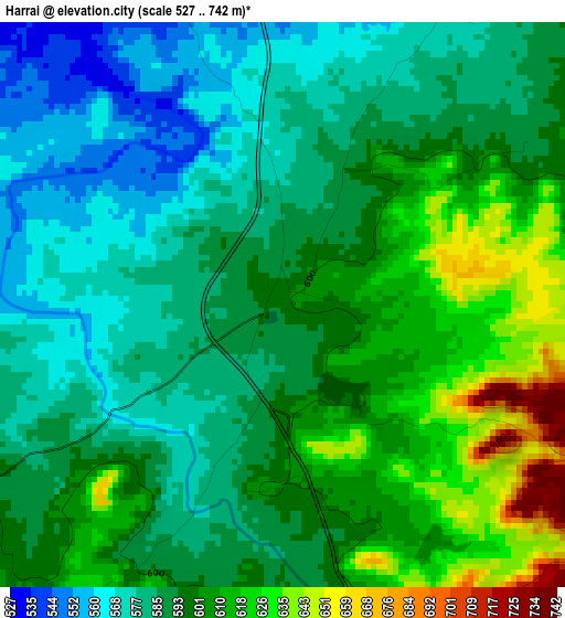
Below is the Elevation map of Harrai, which displays elevation range with different colors. Scale of the first map is from 527 to 742 m (1729 to 2434 ft) with average elevation of 594.8 meters (=1951 ft) [note 1]
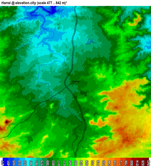
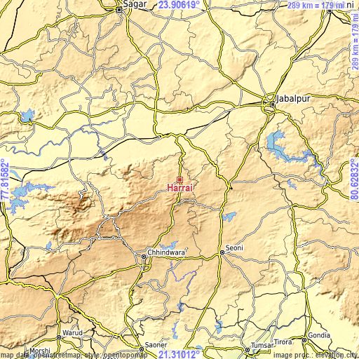
These maps also provides idea of topography and contour of this city, they are displayed at different zoom levels. More info about maps, scale and edge coordinates you can find below images.
| \ | Map #1 | Map #2 | Topo.Map |
| Scale [m] | 527..742 m | 477..842 m | × |
| Scale [ft] | 1729..2434 ft | 1565..2762 ft | × |
| Average | 594.8 m = 1951 ft | 616.6 m = 2023 ft | × |
| Width | 9.02 km = 5.6 mi | 18.04 km = 11.2 mi | 288.7 km = 179.4 mi |
| Height | 9.02 km = 5.6 mi | 18.04 km = 11.2 mi | 288.7 km = 179.4 mi |
| ↑Max Latitude | 22.654841° | 22.695389° | 23.90619° |
| Latitude at center | 22.61428° | 22.61428° | 22.61428° |
| ↓Min Latitude | 22.573707° | 22.533123° | 21.31012° |
| ← Min Longitude | 79.178125° | 79.134179° | 77.81582° |
| Longitude center | 79.22207° | 79.22207° | 79.22207° |
| →Max Longitude | 79.266015° | 79.309961° | 80.62832° |
Nearby cities:
Cities around Harrai sort by population:
• Chhindwāra elevation 688 m
68.4 km,  205°
205°
• Seoni 628 m
67.8 km,  150°
150°
• Narsimhapur 357 m
37.5 km,  353°
353°
• Gādarwāra 339 m
56.5 km,  307°
307°
• Parāsia 781 m
66.9 km,  225°
225°
• Kareli 365 m
37.2 km,  334°
334°
• Bargi 401 m
79 km,  57°
57°
• Lakhnādon 617 m
38.9 km,  92°
92°
• Amarwāra 807 m
35.6 km,  188°
188°
• Shāhpura 379 m
73.6 km,  37°
37°
• Chichli 346 m
47.4 km,  300°
300°
• Ghansor 566 m
74.9 km, 86°
Multilingual:
 En español:
Harrai elevación 598 m.
 En France:
Harrai élévation 598 m.


Sources and notes:
- [note 1] Map square and city borders are not equal. Map elevation data is calculated only from area inside that square.
- [src 1] Elevation data from geonames database provided with same terms of usage.
- [src 2] The elevation map of Harrai is generated using elevation data from NASA's 3 arcsec (90m) resolution SRTM data.
- [src 3] Base (background) map © OpenStreetMap contributors tiles are generated by Geofabrik and OpenTopoMap.
Copyright & License:
This Harrai Elevation Map is licensed under CC BY-SA. You may reuse any part from this page, if you give a proper credit by linking to this URL:
 More info on terms of use page.